Kaufungen Forest

Last updated

The Kaufungen Forest (German : Kaufunger Wald) is a range of steep, wooded hills straddling the border between the states of Hesse and Lower Saxony in central Germany. It takes its name from the town Kaufungen.

The hills lie in the fork of the Rivers Fulda and Werra, which meet at Hannoversch Münden just to the north. They are bounded to the west and north-west by the Fulda valley, and to the east and north-east by the Werra valley. The southern boundary is less clearly defined, as the range merges into the gentler hills of the Söhrewald to the south-west, and climbs towards the high plateau of the Hoher Meißner to the south-east.

Bilstein Tower Bilstein Tower.jpg
Bilstein Tower

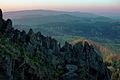
The highest natural point is 643 m (2,110 ft) Hirschberg; however the 641 m (2,103 ft) summit of Bilstein forms a much better natural viewpoint, and since 1869 has been crowned with an observation tower. The present tower was erected in 1889 and extended to its present height of 20 m (66 ft) in 1960; it offers panoramic views across the region. Other peaks include Mühlenstein (607 m (1,991 ft)), Haferberg (581 m (1,906 ft)), Langenberg (565 m (1,854 ft)), Großer Steinberg (542 m (1,778 ft)) and Kleiner Steinberg (542 m (1,778 ft)).

The area is popular for walking and especially for cycling; an extensive network of waymarked forestry and agricultural tracks provide excellent traffic-free routes. The annual Bilstein Bike Marathon attracts hundreds of mountain bikers to compete in races of varying length and difficulty. In winter, the same trails are used for cross-country skiing. The main tourist centre for the area is the small town of Großalmerode. Other settlements include Kaufungen (which lends its name to the range), Helsa and Nieste. The larger towns of Kassel, Witzenhausen and Hessisch Lichtenau lie on the western, eastern and southern fringes respectively.

The entire of the area enjoys protected status; the hills in Hesse form part of the Meißner-Kaufungen Forest Nature Park, while those in Lower Saxony belong to the Münden Nature Park. However, the southern part of the range may be affected by the planned extension of the A 44 autobahn from its present end in Kassel to Eisenach. The controversial extension, which has been delayed and rerouted several times on environmental grounds, is part of a national strategy to improve communications between the east and west of Germany, in the wake of reunification.

Coordinates: 51°14′44″N9°45′19″E / 51.24556°N 9.75528°E / 51.24556; 9.75528

Related Research Articles

<span class="mw-page-title-main">Göttingen (district)</span> District in Lower Saxony, Germany

Göttingen is a district in Lower Saxony, Germany. It is bounded by the districts of Northeim and Goslar, and by the states of Thuringia and Hesse.

<span class="mw-page-title-main">Fulda (river)</span> River in Germany

The Fulda is a river of Hesse and Lower Saxony, Germany. It is one of two headstreams of the Weser. The Fulda is 220.4 kilometres (137.0 mi) long.

<span class="mw-page-title-main">Witzenhausen</span> Town in Hesse, Germany

Witzenhausen is a small town in the Werra-Meißner-Kreis in northeastern Hesse, Germany.

<span class="mw-page-title-main">Hoher Meißner</span> Mountain in Germany

The Hoher Meißner is a mountain massif with a height of 753.6 m and is located in the Meißner-Kaufunger Wald nature park in Hesse, Germany.

<span class="mw-page-title-main">Kaufungen</span> Municipality in Hesse, Germany

Kaufungen is a municipality in the district of Kassel, in Hesse, Germany. It is situated in the narrow valley of the river Losse, surrounded by the steep, wooded hills of the Kaufunger Wald, approx. 10 kilometres east of Kassel.

Bilstein may refer to:

<span class="mw-page-title-main">Großalmerode</span> Town in Hesse, Germany

Großalmerode is a town in the Werra-Meißner-Kreis in Hesse, Germany.

<span class="mw-page-title-main">Waldkappel</span> Town in Hesse, Germany

Waldkappel is a small town in the Werra-Meißner-Kreis district in northern Hesse, Germany.

<span class="mw-page-title-main">Meißner, Hesse</span> Municipality in Hesse, Germany

Meißner is a municipality in the Werra-Meißner-Kreis in Hesse, Germany.

<span class="mw-page-title-main">Neu-Eichenberg</span> Municipality in Hesse, Germany

Neu-Eichenberg is a municipality in the Werra-Meißner-Kreis in Hesse, Germany.

<span class="mw-page-title-main">Frau-Holle-Teich</span>

Frau-Holle-Teich is a pond in Hoher Meißner, Werra-Meißner-Kreis, Hesse, Germany. The pond lies at an elevation of ca. 623 m.

The East Hesse Highlands describes a heavily wooded range of hills lying mainly in the German state of Hesse, but also extending a little way into Lower Saxony to the north, Thuringia to the east and Bavaria to the southeast. The region is sandwiched between the West Hesse Depression to the west, the Weser Uplands to the north, the Thuringian Basin to the northeast, the northwestern edge of the Thuringian Forest to the east, the Spessart to the south and the Wetterau to the southwest.

<span class="mw-page-title-main">Reinhardswald</span>

The Reinhardswald is a range of hills up to 472.2 m above sea level (NN) and covering an area of over 200 km² in the Weser Uplands in the district of Kassel, Hesse (Germany). Of this, 183 km² are part of the unincorporated area known as Gutsbezirk Reinhardswald.

<span class="mw-page-title-main">Bramwald</span> Hill range in Germany

The Bramwald is a range of hills up to 408.1 m above sea level (NN) in the Weser Uplands in Lower Saxony (Germany). It is a unique, natural, wild, hill and forest landscape. This is particularly so in the north around the Totenberg.

The Haferberg is a hill, 580.4 m above sea level (NN), in the Kaufungen Forest in Hesse and Lower Saxony in Germany.

<span class="mw-page-title-main">Halle–Hann. Münden railway</span>

The Halle–Hann. Münden railway is a 218 km long main line operated by the Deutsche Bahn in Germany, which links Halle (Saale) in Saxony-Anhalt with Hann. Münden in the state of Lower Saxony. It is mainly used by regional and east-west goods trains. From 1990 to 1994 it was upgraded as part of a German Unification Transport Project.

<span class="mw-page-title-main">Münden Nature Park</span>

The Münden Nature Park lies within the district of Göttingen, in south Lower Saxony in Germany.

The Fulda-Werra Uplands are a major natural regional unit in the East Hesse Highlands in East and North Hesse and, with small elements in the southeast, in the German state of Thuringia. Most of the range lies right of the River Fulda and left of the Werra. The uplands extend from the Rhön mountains northwards, to the River Weser near Hann. Münden.

The Söhre is a forested hill range of the German Central Uplands and a subordinate natural region of the Fulda-Werra Uplands in North Hesse, Germany.