Witzenhausen is a small town in the Werra-Meißner-Kreis in northeastern Hesse, Germany.
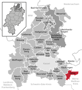
Helsa is a municipality and village in the district of Kassel, in Hesse, Germany. The municipality is situated in the Losse valley amongst the hills of the Kaufunger Wald, approx. 15 km east of Kassel.

Vellmar is a town in the Kassel district, in Hesse, Germany. It is located on the Ahne river.

Twistetal is a municipality in Waldeck-Frankenberg in northwest Hesse, Germany, southwest of Bad Arolsen.

Baunatal is a town in the district of Kassel, in Hesse, Germany. It is a comparatively young town which arose from fusion of the formerly independent municipalities Altenbauna, Altenritte, Großenritte, Guntershausen, Hertingshausen, Kirchbauna and Rengershausen in 1966.

Nidderau is a town in the Main-Kinzig district, in Hesse, Germany. It is situated approximately 12 km north of Hanau, and 20 km northeast of Frankfurt. Nidderau was created in the merger of the municipality of Heldenbergen with the town of Windecken on January 1, 1970. Eichen and Erbstadt joined Nidderau on January 1, 1972 and Ostheim merged with Nidderau in July 1974.
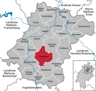
Frielendorf is a municipality in the Schwalm-Eder district, Hesse, Germany.

Guxhagen is a municipality in Schwalm-Eder district in northern Hesse, Germany.

Hessisch Lichtenau (German pronunciation:[ˈhɛsɪʃˈlɪçtənaʊ̯] is a small town in the Werra-Meißner-Kreis in eastern Hesse, Germany. In 2006, the town hosted the 46th Hessentag state festival.
Lohfelden is a municipality in the district of Kassel, in Hesse, Germany. It is situated 6 km southeast of Kassel. It has three parts Crumbach, Ochshausen and the former independent Vollmarshausen.

Fuldatal is a municipality in the district of Kassel, in Hesse, Germany. It is situated along the Fulda River, 5 km northeast of Kassel.
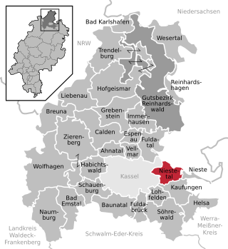
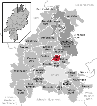
Niestetal is a municipality in the district of Kassel, in Hesse, Germany. It is situated on the eastern bank of the Fulda, 4 km east of Kassel (centre).

Bad Karlshafen is a baroque, thermal salt spa town in the district of Kassel, in Hesse, Germany. It has 2300 inhabitants in the main ward of Bad Karlshafen, and a further 1900 in the medieval village of Helmarshausen. It is situated at the confluence of the Diemel and Weser rivers, 15 km south of Höxter, and 37 km north of Kassel.

Bad Emstal is a municipality in the district of Kassel, in Hesse, Germany. It is situated 19 km southwest of Kassel, Germany.
Breuna is a small municipality in the district of Kassel, in Hesse, Germany. It is situated 24 kilometers northwest of the town of Kassel. Its oldest part is the village of Rhöda, first mentioned in the early ninth century.

Calden is a municipality in the district of Kassel in Hesse, Germany. It is located 12 km northwest of the city of Kassel, and the Kassel Airport is situated near Calden.
Espenau is a municipality in the district of Kassel, in Hesse, Germany. It is composed of two districts the Espenau-Hohenkirchen, and the Espenau-Mönchehof both are situated 9 kilometers north of Kassel. As of December 2019, Espenau has 5,158 inhabitants. It covers a total area of 13.59 km2.

Fuldabrück is a municipality in the district of Kassel, in Hesse, Germany. It is situated along the Fulda river, 8 kilometers south of Kassel. The municipality of Fuldabrück consists of the former independent villages Bergshausen, Dittershausen, Dennhausen and Dörnhagen.

Söhrewald is a municipality in the district of Kassel, in Hesse, Germany. It is located 13 kilometers southeast of Kassel. The municipality was formed by the former independent municipalities Eiterhagen, Wattenbach and Wellerode in 1970.
The Söhre is a forested hill range of the German Central Uplands and a subordinate natural region of the Fulda-Werra Uplands in North Hesse, Germany.


