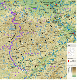
The Eifel is a low mountain range in western Germany and eastern Belgium. It occupies parts of southwestern North Rhine-Westphalia, northwestern Rhineland-Palatinate and the southern area of the German-speaking Community of Belgium.
Vulkaneifel is a district (Kreis) in the northwest of the state Rhineland-Palatinate, Germany. It is the least densely populated district in the state and the fourth most sparsely populated district in Germany. The administrative centre of the district is in Daun. Neighboring districts are Euskirchen, Ahrweiler, Mayen-Koblenz, Cochem-Zell, Bernkastel-Wittlich, and Bitburg-Prüm.

Daun is a town in the Vulkaneifel district in Rhineland-Palatinate, Germany. It is the district seat and also the seat of the Verbandsgemeinde of Daun.

Manderscheid is a town in the Bernkastel-Wittlich district in Rhineland-Palatinate, Germany, and also both a climatic spa and a Kneipp spa. Until 1 July 2014, when it became part of the Verbandsgemeinde Wittlich-Land, it was the seat of the former Verbandsgemeinde Manderscheid.

Ulmen is a town in the Cochem-Zell district in Rhineland-Palatinate, Germany. It is the seat of the like-named Verbandsgemeinde – a kind of collective municipality – to which it also belongs.
Bergweiler is an Ortsgemeinde – a municipality belonging to a Verbandsgemeinde, a kind of collective municipality – in the Bernkastel-Wittlich district in Rhineland-Palatinate, Germany.
Beuren is an Ortsgemeinde – a municipality belonging to a Verbandsgemeinde, a kind of collective municipality – in the Cochem-Zell district in Rhineland-Palatinate, Germany. It belongs to the Verbandsgemeinde of Ulmen, whose seat is in the like-named town.

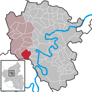
Boos is a municipality in the county of Mayen-Koblenz in Rhineland-Palatinate, western Germany.

Duppach is an Ortsgemeinde, part of a group of municipalities called the Verbandsgemeinde of Gerolstein, which is located in the town of Gerolstein in the Vulkaneifel district of the state of Rhineland-Palatinate, Germany.

Schalkenmehren is an Ortsgemeinde – a municipality belonging to a Verbandsgemeinde, a kind of collective municipality – in the Vulkaneifel district in Rhineland-Palatinate, Germany. It belongs to the Verbandsgemeinde of Daun, whose seat is in the like-named town.

Steffeln is an Ortsgemeinde – a municipality belonging to a Verbandsgemeinde, a kind of collective municipality – in the Vulkaneifel district in Rhineland-Palatinate, Germany. It belongs to the Verbandsgemeinde of Gerolstein, whose seat is in the municipality of Gerolstein.

The Hohe Acht is the highest mountain in the Eifel mountains of Germany. It is located on the boundary between the districts of Ahrweiler and Mayen-Koblenz in Rhineland-Palatinate.
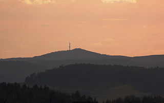
At 674.9 metres (2,214 ft) the Hochkelberg is one of the ten highest mountains in the Vulkan Eifel in Germany. It is a former stratovolcano, at the southern foot of which lies the Mosbrucher Weiher, an explosion crater lake or maar. Below the summit of the Hochkelberg is a transmission tower.

The Ahr Hills are a range of low mountains and hills up to 623.8 m above sea level (NHN) and 25 kilometres (16 mi) long in the Eifel region of Germany, which lie roughly southwest of Bonn on the border between the German states of North Rhine-Westphalia and Rhineland-Palatinate.

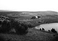
The Booser Doppelmaar comprises two maars that have silted up and, today, form shallow depressions in the countryside. They lie on the territory of the village of Boos, a few hundred metres west of the village itself. The two maars were formed 10,150 to 14,160 years ago and belong to the Quaternary volcano field of the Volcanic Eifel. From a natural region perspective it lies in the south of the Hohe Acht Upland, ca. 7.8 km south of the summit of the Hohe Acht.

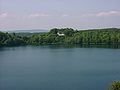
The Pulvermaar is a water-filled maar that lies southeast of Daun in the German state of Rhineland-Palatinate. Together with the Holzmaar it is one of the Gillenfeld maars.

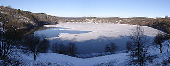
The Meerfelder Maar is a maar by the village of Meerfeld not far from the town of Manderscheid in the Eifel in the German state of Rhineland-Palatinate.

The Gemündener Maar is the northernmost of the three Daun Maars. It lies in the immediate vicinity of the village of Gemünden and ca. 1.5 km south of Daun in the Eifel and in the German state of Rhineland-Palatinate.

The Dreiser Weiher near Dreis-Brück in the vicinity of Daun in the German state of Rhineland-Palatinate is a tub-shaped maar in the Eifel mountains. It is up to 1,360 metres long and 1,160 metres wide. It is the second largest maar in the Eifel.
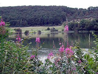
The Immerather Maar is a maar in the municipality of Immerath in the county of Vulkaneifel in the German state of Rhineland-Palatinate. It is part of a designated nature reserve and Special Area of Conservation.