Vulkaneifel is a district (Kreis) in the northwest of the state Rhineland-Palatinate, Germany. It is the least densely populated district in the state and the fourth most sparsely populated district in Germany. The administrative centre of the district is in Daun. Neighboring districts are Euskirchen, Ahrweiler, Mayen-Koblenz, Cochem-Zell, Bernkastel-Wittlich, and Bitburg-Prüm.

Puy de Dôme is a lava dome and one of the youngest volcanoes in the Chaîne des Puys region of Massif Central in central France. This chain of volcanoes including numerous cinder cones, lava domes and maars is far from the edge of any tectonic plate. Puy de Dôme was created by a Peléan eruption, some 10,700 years ago. Puy de Dôme is approximately 10 km from Clermont-Ferrand. The Puy-de-Dôme département is named after the volcano.

Mount Cameroon is an active volcano in the South West region of Cameroon next to the city of Buea near the Gulf of Guinea. Mount Cameroon is also known as Cameroon Mountain or Fako or by its indigenous name Mongo ma Ndemi. It is the highest point in sub-Saharan western and central Africa, the fourth-most prominent peak in Africa, and the 31st-most prominent in the world. The mountain is part of the area of volcanic activity known as the Cameroon Volcanic Line, which also includes Lake Nyos, the site of a disaster in 1986. The most recent eruption occurred on February 3, 2012.

Ometepe is an island formed by two volcanoes rising out of Lake Nicaragua in the Republic of Nicaragua. Its name derives from the Nahuatl words ome (two) and tepetl (mountain), meaning "two mountains". It is the largest island in Lake Nicaragua.

Caldera de Taburiente National Park is a national park on the island of La Palma, Canary Islands, Spain. It contains the Caldera de Taburiente, which dominates the northern part of the island, and was designated as a national park in 1954. The telescopes of the Roque de los Muchachos Observatory are situated very close to the summit.

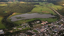
A maar is a broad, low-relief volcanic crater caused by a phreatomagmatic eruption. A maar characteristically fills with water to form a relatively shallow crater lake which may also be called a maar. The name comes from a Moselle Franconian dialect word used for the circular lakes of the Daun area of Germany.

The Poás Volcano,, is an active 2,697-metre (8,848 ft) stratovolcano in central Costa Rica and is located within Poas Volcano National Park. It has erupted 40 times since 1828, including April 2017 when visitors and residents were evacuated. The volcano and surrounding park were closed for nearly 17 months, with a 2.5 kilometer safety perimeter established around the erupting crater. As of September 1, 2018 the park has reopened with limited access only to the crater observation area and requires a reservation to be made on the National Park Website. Adjacent trails to Lake Botos as well as the museum at the visitor center remained closed. The volcano erupted briefly twice in September 2019.

The International Union of Geological Sciences (IUGS) is an international non-governmental organization devoted to international cooperation in the field of geology.

The Messel Pit is a disused quarry near the village of Messel about 35 km (22 mi) southeast of Frankfurt am Main, Germany. Bituminous shale was mined there. Because of its abundance of well-preserved fossils dating from the middle of the Eocene, it has significant geological and scientific importance. Over 1000 species of plants and animals have been found at the site. After almost becoming a landfill, strong local resistance eventually stopped these plans and the Messel Pit was declared a UNESCO World Heritage Site on 9 December 1995. Significant scientific discoveries about the early evolution of mammals and birds are still being made at the Messel Pit, and the site has increasingly become a tourist site as well.
Tower Hill is an inactive volcano on the south-west coast of Victoria, Australia, approximately 275 kilometres (171 mi) west of Melbourne, and 15 kilometres (9 mi) north-west of Warrnambool. The Tower Hill crater is roughly 3 kilometres (2 mi) wide and 80 metres (260 ft) high, with a gradient of between 10% to 80% at the higher points. Within the crater, a series of later volcanic explosions formed a number of scoria cones and spheres, surrounded by a crater lake. Being a giant nested maar, Tower Hill is of international geological significance. The Dhauwurdwurrung name for the volcano is Koroitj.

Ulmen is a town in the Cochem-Zell district in Rhineland-Palatinate, Germany. It is the seat of the like-named Verbandsgemeinde – a kind of collective municipality – to which it also belongs.

Cuicocha is a 3 km (2 mi) wide caldera and crater lake at the foot of Cotacachi Volcano in the Cordillera Occidental of the Ecuadorian Andes.

Mount Yasur is a volcano on Tanna Island, Vanuatu, 361 m (1,184 ft) high above sea level, on the coast near Sulphur Bay, northeast of the taller Mount Tukosmera, which was active in the Pleistocene. It has a largely unvegetated pyroclastic cone with a nearly circular summit crater 400 m in diameter. It is a stratovolcano, caused by the eastward-moving Indo-Australian Plate being subducted under the westward-moving Pacific Plate. It has been erupting nearly continuously for several hundred years, although it can usually be approached safely. Its eruptions, which often occur several times an hour, are classified as Strombolian or Vulcanian. A large lava plain creeps across the valley at the base.

Ḥarrat Khaybar is a volcanic field located north of Medina in the Hejaz, Saudi Arabia. It covers an area approximately 12,000 km2 (4,600 sq mi). The most recent eruption occurred between 600 and 700 AD. Man-made stone structures dating to the Neolithic period have been studied in Harrat Khaybar.

The Volcanic Eifel or Vulkan Eifel is a region in the Eifel Mountains in Germany that is defined to a large extent by its volcanic geological history. Characteristic of this volcanic field are its typical explosion crater lakes or maars, and numerous other signs of volcanic activity such as volcanic tuffs, lava streams and volcanic craters like the Laacher See. The Volcanic Eifel is still volcanically active today. One sign of this activity is the escaping gases in the Laacher See.

Mt Matavanu is an active volcano on the island of Savai'i in Samoa. The volcano was formed during an eruption in 1905. Lava flows from the eruption covered a large area of land in the Gaga'emauga district, leading to the relocation of several villages.

Santorini caldera is a large, mostly submerged caldera, located in the southern Aegean Sea, 120 kilometers north of Crete in Greece. Visible above water is the circular Santorini island group, consisting of Santorini, the main island, Therasia and Aspronisi at the periphery, and the Kameni islands at the center. It has been designated a Decade Volcano.
The Danakil Depression is the northern part of the Afar Triangle or Afar Depression in Ethiopia, a geological depression that has resulted from the divergence of three tectonic plates in the Horn of Africa.
Ulmen Castle is a ruined castle complex in Ulmen, Germany.
Mount Napak is an extinct volcano in the Napak District of Uganda. An alkaline volcano which erupted carbonatite-nephelinite material during the Early Miocene on the margin of the Great Rift Valley, subsequent erosion affords volcanologists an opportunity to inspect its once internal structures. Moreover, volcanic ash deposits and paleosols preserve a range of both animal and plant fossils, significantly including numerous primate taxa.