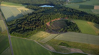
It is one of the Daun Maars (Dauner Maare) or Daun Maar Group and is a double maar, comprising a western maar lake and an eastern dry maar. Both were formed around 10,500 years ago as the result of a phreatomagmatic explosion. The lake in the western part of the maar varies between 500 and 575 metres in diameter and is up to 21 metres deep. The height of the maar above sea level is 420 metres (average elevation of the water surface). It fills the more recent of the 2 maar basins. The eastern part of the maar is occupied by a raised bog.
Werner D’hein: Natur- und Kulturführer Vulkanlandeifel. Mit 26 Stationen der "Deutschen Vulkanstraße". Gaasterland-Verlag, Düsseldorf, 2006. ISBN3-935873-15-8
The Democratic Republic of the Congo (DRC) is the largest country of sub-Saharan Africa, occupying some 2,344,858 square kilometres (905,355 sq mi). Most of the country lies within the vast hollow of the Congo River basin. The vast, low-lying central area is a plateau-shaped basin sloping toward the west, covered by tropical rainforest and criss-crossed by rivers. The forest center is surrounded by mountainous terraces in the west, plateaus merging into savannas in the south and southwest. Dense grasslands extend beyond the Congo River in the north. High mountains of the Ruwenzori Range are found on the eastern borders with Rwanda and Uganda.
Ghana is a West African country in Africa, along the Gulf of Guinea.
A bog or bogland is a wetland that accumulates peat as a deposit of dead plant materials – often mosses, typically sphagnum moss. It is one of the four main types of wetlands. Other names for bogs include mire, mosses, quagmire, and muskeg; alkaline mires are called fens. A bayhead is another type of bog found in the forest of the Gulf Coast states in the United States. They are often covered in heath or heather shrubs rooted in the sphagnum moss and peat. The gradual accumulation of decayed plant material in a bog functions as a carbon sink.
Vulkaneifel is a district (Kreis) in the northwest of the state Rhineland-Palatinate, Germany. It is the least densely populated district in the state and the fourth most sparsely populated district in Germany. The administrative centre of the district is in Daun. Neighboring districts are Euskirchen, Ahrweiler, Mayen-Koblenz, Cochem-Zell, Bernkastel-Wittlich, and Bitburg-Prüm.
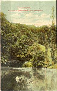
The Aachtopf is Germany's biggest karst spring, south of the western end of the Swabian Jura near the town of Aach. It produces an average of 8,500 litres per second. Most of the water stems from the River Danube where it disappears underground at the Danube Sinkhole, 12 kilometres (7.5 mi) north near Immendingen and about 14 kilometres (8.7 mi) north near Fridingen. The cave system has been explored since the 1960s, but as of 2020 only a small part has been discovered due to a large blockage after a few hundred metres.
Lake Balkhash, also spelt Lake Balqash, is a lake in southeastern Kazakhstan, one of the largest lakes in Asia and the 15th largest in the world. It is located in the eastern part of Central Asia and sits in the Balkhash-Alakol Basin, an endorheic (closed) basin. The basin drains seven rivers, the primary of which is the Ili, bringing most of the riparian inflow; others, such as the Karatal, bring surface and subsurface flow. The Ili is fed by precipitation, largely vernal snowmelt, from the mountains of China's Xinjiang region.
A maar is a broad, low-relief volcanic crater caused by a phreatomagmatic eruption. A maar characteristically fills with water to form a relatively shallow crater lake, which may also be called a maar.
The Dümmer or officially Dümmer See is a large lake in southern Lower Saxony (Germany). It has a surface of 13.5 km2 and an average depth of one metre. Its elevation is 37 metres.
Lough Derravaragh is a lake in County Westmeath, Ireland, north of Mullingar between Castlepollard, Crookedwood and Multyfarnham.
Raised bogs, also called ombrotrophic bogs, are acidic, wet habitats that are poor in mineral salts and are home to flora and fauna that can cope with such extreme conditions. Raised bogs, unlike fens, are exclusively fed by precipitation (ombrotrophy) and from mineral salts introduced from the air. They thus represent a special type of bog, hydrologically, ecologically and in terms of their development history, in which the growth of peat mosses over centuries or millennia plays a decisive role. They also differ in character from blanket bogs which are much thinner and occur in wetter, cloudier climatic zones.
The Maujahn or Maujahn Moor is a kettle bog in North Germany which began as a sinkhole. It is located a good two kilometres west of the town of Dannenberg between the villages of Thunpadel and Schmarsau in northeastern Lower Saxony.
The Georgenfelder Hochmoor is a raised bog (Hochmoor) in the German Ore Mountains of central Europe, not far from Zinnwald-Georgenfeld. It is part of a larger bog or moor complex, that lies to the south, mainly on the far side of the Germany's national border in the Czech Republic and which, since time immemorial, has been known simply as "The Lake". The Georgenfelder Hochmoor is one of the oldest nature reserves in Saxony.
The Dürres Maar is a maar located in the vicinity of the village of Gillenfeld, Germany in the West Eifel mountains about 400 metres northwest of the Holzmaar. The Dürres Maar ist a dry maar, the original maar lake has silted up. It is surrounded by an embankment of lapilli-tuff which has only been gently eroded and has a diameter of about 290 metres. The Dürres Maar was formed more than 25,000 years ago.
The Pulvermaar is a water-filled maar that lies southeast of Daun in the German state of Rhineland-Palatinate. Together with the Holzmaar it is one of the Gillenfeld maars.
The Meerfelder Maar is a maar by the village of Meerfeld not far from the town of Manderscheid in the Eifel in the German state of Rhineland-Palatinate.
The Gemündener Maar is the northernmost of the three Daun Maars. It lies in the immediate vicinity of the village of Gemünden and ca. 1.5 km south of Daun in the Eifel and in the German state of Rhineland-Palatinate.
The Dreiser Weiher near Dreis-Brück in the vicinity of Daun in the German state of Rhineland-Palatinate is a tub-shaped maar in the Eifel mountains. It is up to 1,360 metres long and 1,160 metres wide. It is the second largest maar in the Eifel.
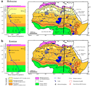
Lake Ptolemy is a former lake in Sudan. This lake formed during the Holocene in the Darfur region, during a time when the monsoon over Africa was stronger. The existence of the lake is dated between about 9,100–2,400 years before present. This lake could have reached a surface area of 30,750 square kilometres (11,870 sq mi), larger than present-day Lake Erie, although estimates of its size vary and it might have been much smaller. The shorelines in some places, insofar as they are recognizable, feature riparian landscapes and reeds. The lake was a freshwater lake replenished by groundwater and runoff from neighbouring mountains and might itself have been the source for the Nubian Sandstone Aquifer System. The lake featured a diverse ecosystem with a number of species, and possibly facilitated the spread of species between the Nile and Lake Chad.
The Mosbrucher Weiher, also called the Mosbrucher Maar, is a silted up maar east of the municipal boundary of the village of Mosbruch in the county Vulkaneifel in Germany. It is located immediately at the foot of the 675-metre-high Hochkelberg, a former volcano. The floor of the maar is in the shape of an elongated oval and is about 700×500 metres in size, its upper boundary has a diameter of about 1,300 × 1,050 metres. This makes the Mosbrucher Maar the third largest of the maars in the western Eifel region. The Üßbach stream flows past and close to the Mosbrucher Weiher.
The Ashchysu is a river in the Bukhar-Zhyrau District, Karaganda Region, and May District, Pavlodar Region, Kazakhstan. It is 348 kilometres (216 mi) long and has a catchment area of 7,420 square kilometres (2,860 sq mi).
This page is based on this Wikipedia article Text is available under the CC BY-SA 4.0 license; additional terms may apply. Images, videos and audio are available under their respective licenses.