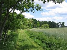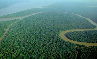
A forest is an ecosystem characterized by a dense community of trees. Hundreds of definitions of forest are used throughout the world, incorporating factors such as tree density, tree height, land use, legal standing, and ecological function. The United Nations' Food and Agriculture Organization (FAO) defines a forest as, "Land spanning more than 0.5 hectares with trees higher than 5 meters and a canopy cover of more than 10 percent, or trees able to reach these thresholds in situ. It does not include land that is predominantly under agricultural or urban use." Using this definition, Global Forest Resources Assessment 2020 found that forests covered 4.06 billion hectares, or approximately 31 percent of the world's land area in 2020.

Quercus kelloggii, the California black oak or Kellogg oak, is an oak in the red oak section native to western North America. Although genetically separated from them for more than 20 million years, its leaves are remarkably similar in appearance to several other members of the red oak section including the red oak and the black oak found in eastern and central North America.

In ecology, edge effects are changes in population or community structures that occur at the boundary of two or more habitats. Areas with small habitat fragments exhibit especially pronounced edge effects that may extend throughout the range. As the edge effects increase, the boundary habitat allows for greater biodiversity.

The Harz is a highland area in northern Germany. It has the highest elevations for that region, and its rugged terrain extends across parts of Lower Saxony, Saxony-Anhalt, and Thuringia. The name Harz derives from the Middle High German word Hardt or Hart. The name Hercynia derives from a Celtic name and could refer to other mountain forests, but has also been applied to the geology of the Harz. The Brocken is the highest summit in the Harz with an elevation of 1,141.1 metres (3,744 ft) above sea level. The Wurmberg is the highest peak located entirely within the state of Lower Saxony.

A savanna or savannah is a mixed woodland-grassland ecosystem characterised by the trees being sufficiently widely spaced so that the canopy does not close. The open canopy allows sufficient light to reach the ground to support an unbroken herbaceous layer consisting primarily of grasses. There exists four savanna forms; savanna woodland where trees and shrubs form a light canopy, tree savanna with scattered trees and shrubs, shrub savanna with distributed shrubs, and grass savanna where trees and shrubs are mostly nonexistent.

A shrubbery, shrub border or shrub garden is a part of a garden where shrubs, mostly flowering species, are thickly planted. The original shrubberies were mostly sections of large gardens, with one or more paths winding through it, a less-remembered aspect of the English landscape garden with very few original 18th-century examples surviving. As the fashion spread to smaller gardens, linear shrub borders covered up walls and fences, and were typically underplanted with smaller herbaceous flowering plants. By the late 20th century, shrubs, trees and smaller plants tend to be mixed together in the most visible parts of the garden, hopefully blending successfully. At the same time, shrubs, especially very large ones, have become part of the woodland garden, mixed in with trees, both native species and imported ornamental varieties.

The Great Basin Desert is part of the Great Basin between the Sierra Nevada and the Wasatch Range. The desert is a geographical region that largely overlaps the Great Basin shrub steppe defined by the World Wildlife Fund, and the Central Basin and Range ecoregion defined by the U.S. Environmental Protection Agency and United States Geological Survey. It is a temperate desert with hot, dry summers and snowy winters. The desert spans large portions of Nevada and Utah, and extends into eastern California. The desert is one of the four biologically defined deserts in North America, in addition to the Mojave, Sonoran, and Chihuahuan Deserts.

An ecotone is a transition area between two biological communities, where two communities meet and integrate. It may be narrow or wide, and it may be local or regional. An ecotone may appear on the ground as a gradual blending of the two communities across a broad area, or it may manifest itself as a sharp boundary line.
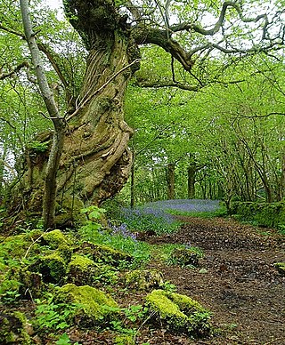
In the United Kingdom, ancient woodland is that which has existed continuously since 1600 in England, Wales and Northern Ireland. Planting of woodland was uncommon before those dates, so a wood present in 1600 is likely to have developed naturally.

Carpinus betulus, the European or common hornbeam, is a species of tree in the birch family Betulaceae, native to Western Asia and central, eastern, and southern Europe, including southern England. It requires a warm climate for good growth, and occurs only at elevations up to 1,000 metres (3,281 ft). It grows in mixed stands with oak, and in some areas beech, and is also a common tree in scree forests. Hornbeam was also known as yoke elm.

An oak savanna is a type of savanna—or lightly forested grassland—where oaks are the dominant trees. The terms "oakery" or "woodlands" are also used commonly, though the former is more prevalent when referencing the Mediterranean area. These savannas were maintained historically through wildfires set by lightning, humans, grazing, low precipitation, and/or poor soil.

Betula papyrifera is a short-lived species of birch native to northern North America. Paper birch is named after the tree's thin white bark, which often peels in paper-like layers from the trunk. Paper birch is often one of the first species to colonize a burned area within the northern latitudes, and is an important species for moose browsing. Primary commercial uses for paper birch wood are as boltwood and sawlogs, while secondary products include firewood and pulpwood. It is the provincial tree of Saskatchewan and the state tree of New Hampshire.
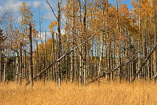
Aspen parkland refers to a very large area of transitional biome between prairie and boreal forest in two sections, namely the Peace River Country of northwestern Alberta crossing the border into British Columbia, and a much larger area stretching from central Alberta, all across central Saskatchewan to south central Manitoba and continuing into small parts of the US states of Minnesota and North Dakota. Aspen parkland consists of groves of aspen, poplar and spruce, interspersed with areas of prairie grasslands, also intersected by large stream and river valleys lined with aspen-spruce forests and dense shrubbery. This is the largest boreal-grassland transition zone in the world and is a zone of constant competition and tension as prairie and woodlands struggle to overtake each other within the parkland.
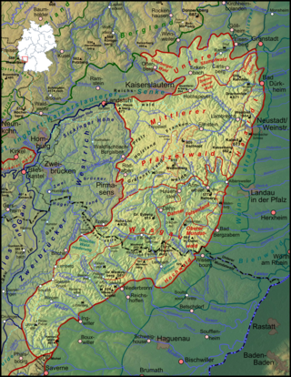
The Palatinate Forest, sometimes also called the Palatine Forest, is a low-mountain region in southwestern Germany, located in the Palatinate in the state of Rhineland-Palatinate. The forest is a designated nature park covering 1,771 km2 and its highest elevation is the Kalmit.
Livingstone is a national park and state conservation area located 30 kilometres (19 mi) south of Wagga Wagga and 10 kilometres (6.2 mi) east of Mangoplah, in the South West Slopes region of south western New South Wales.
The Mbam Djerem National Park is found in Cameroon. It was established in 2000 and covers 4234.78 km2.

The history of Central European forests is characterised by thousands of years of exploitation by people. Thus a distinction needs to be made between the botanical natural history of the forest in pre- and proto-historical times—which falls mainly into the fields of natural history and Paleobotany—and the onset of the period of sedentary settlement which began at the latest in the Neolithic era in Central Europe - and thus the use of the forest by people, which is covered by the disciplines of history, archaeology, cultural studies and ecology.
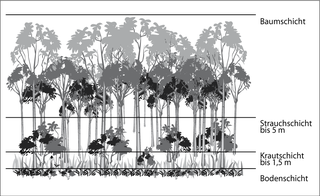
Stratification in the field of ecology refers to the vertical layering of a habitat; the arrangement of vegetation in layers. It classifies the layers of vegetation largely according to the different heights to which their plants grow. The individual layers are inhabited by different animal and plant communities (stratozones).

In the Western history of gardening, from the 16th to early 19th centuries, a wilderness was a highly artificial and formalized type of woodland, forming a section of a large garden. Though examples varied greatly, a typical English style was a number of geometrically-arranged compartments closed round by hedges, each compartment planted inside with relatively small trees. Between the compartments there were wide walkways or "alleys", usually of grass, sometimes of gravel. The wilderness provided shade in hot weather, and relative privacy. Though often said by garden writers at the time to be intended for meditation and reading, the wilderness was much used for walking, and often flirtation. There were few if any flowers, but there might be statues, and some seating, especially in garden rooms or salle vertes, clearings left empty. Some had other features, such as a garden maze.

A woodland garden is a garden or section of a garden that includes large trees and is laid out so as to appear as more or less natural woodland, though it is often actually an artificial creation. Typically it includes plantings of flowering shrubs and other garden plants, especially near the paths through it.
