Conflicting dates have been estimated for the last eruption of the volcano: of 4,300years ago,[1] of 28,000years ago,[2] and a little before 6,000 years ago.[2][3] If the youngest date is correct, this could be the most recent volcanic eruption on the Australian mainland.[citation needed]
Blue Lake / Warwar (also Waawar) is one of four lakes in the Dormant volcano complex. Sites of cultural significance to the Boandik people were assigned dual names by the City of Mount Gambier in February 2022, and the renaming included the four lakes in the Bungandidj language. These are as follows:[4][5]
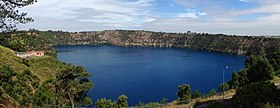
The bottom of Blue Lake is basically flat, having an average depth of around 72 metres (~238 feet). The crater rim measures 1,200 by 824m (3,937 by 2,703ft), but the lake itself measures 1,087 by 657m (3,566 by 2,156ft). The surface of the lake is 17m (56ft) below the level of the main street of the nearby town. Blue Lake supplies the town with drinking water.[citation needed]
Browne's Lake / Kroweratwari (sometimes spelt Browns Lake) dried up in the 1980s, and is now a picnic spot.[6]
There is a 3.6km (2.2mi) road and walking track around the circumference of Blue Lake / Warwar, with an underpass between it and Leg of Mutton Lake / Yatton Loo.[7]
Annual colour change
The Blue Lake in early MarchBlue Lake / Warwar in June
Each November, the lake turns to a deep turquoise colour, gradually returning to a duller blue colour in late February to March.[7] The exact cause of this phenomenon is still a matter of conjecture, but likely it involves the warming of the surface layers of the lake during the summer to around 20°C (68°F), causing calcium carbonate to precipitate out of the solution and enabling microcrystallites of calcium carbonate to form. This results in scatter of the blue wavelengths of sunlight. During winter, the lake becomes well mixed, and recent research indicates that during this phase of the colour cycle, the lake is somewhat murkier due to the redistribution of tannins and calcium carbonate particles throughout the lake. Solar elevation has also been found to influence the perceived colour of the lake. The movement of planktonic life forms within the lake during the seasons and during the day may additionally play a part in the colour change.[citation needed]
Studies
Bathymetric surveys located the deepest point in the lake at 77m (253ft) in 1967.[8] Major diving exploration of the lake first occurred in 1985, when a dive team led by cave diver Peter Horne conducted temperature and visibility studies and made discoveries of a freshwater sponge species and other invertebrates.[8] This exploration also discovered the Stromatolite Field, a collection of hollow rock formations that are found mainly along the north-eastern perimeter down to a depth of 40m (130ft).[8] Horne coordinated four additional studies (in winter 1985 and the summers of 1987, 1989 & 1991) in conjunction with specialists from the South Australian Museum, Adelaide University and Monash University, and in 2008 permission was granted by SA Water for another diving exploration of the central and deepest parts of the lake.[8] This dive team was coordinated by Dr Richard Harris; core samples were collected from the calcite-silt covered lake bed where water temperature dropped to 14°C (57°F).[citation needed]
Gordon's leap
The Gordon obelisk at the Blue Lake
In July 1865, Adam Lindsay Gordon performed the daring riding feat known as Gordon's Leap on the edge of the Blue Lake. A commemorative obelisk erected there has an inscription which reads:[9]
This obelisk was erected as a memorial to the famous Australian poet. From near this spot in July, 1865, Gordon made his famed leap on horseback over an old post and rail guard fence onto a narrow ledge overlooking the Blue Lake and jumped back again onto the roadway. The foundation stone of the Gordon Memorial Obelisk was laid on 8th July 1887
Gallery
About 4m (13ft) above the lake's surface
The lake in early March with the original pumping station in the foreground
↑ Gouramanis, Chris; Wilkins, Daniel; De Deckker, Patrick (2010). "6000 years of environmental changes recorded in Blue Lake, South Australia, based on ostracod ecology and valve chemistry". Palaeogeography, Palaeoclimatology, Palaeoecology. 297: 223. doi:10.1016/j.palaeo.2010.08.005. hdl:1885/53594.
Emeny, J., Turner, G., Turoczy, N.J. and Stagnitti, F. (2006) The influence of weather and solar elevation on perceived colour of Blue Lake, Mount Gambier, South Australia. Transactions of the Royal Society of South Australia. 130(1) 101–108.
Sheard, M.J. (1978) Geological History of the Mount Gambier Volcanic Complex, Southeast South Australia. Transcript from Royal Society of South Australia 102(5), Aug. 1978.
Telfer, A. (2000) Identification of processes regulating the colour and colour change in an oligotrophic, hardwater, groundwater-fed lake, Blue Lake, Mount Gambier, South Australia. Lakes and Reservoirs: Research and Management. 5 161–176.
Turoczy, N.J. (2002) Calcium chemistry of Blue Lake, Mt Gambier, Australia, and relevance to remarkable seasonal colour changes. Archiv für Hydrobiologia. 156 (1) 1–9.
This page is based on this Wikipedia article Text is available under the CC BY-SA 4.0 license; additional terms may apply. Images, videos and audio are available under their respective licenses.