Ladislao Cabrera is a province in the southern parts of the Bolivian department of Oruro. It is named after Ladislao Cabrera. Its seat is Salinas de Garci Mendoza.
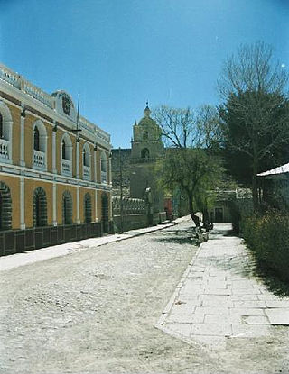
Salinas de Garci Mendoza is a town in the Bolivian Oruro Department. It is the administrative center of Ladislao Cabrera Province and is located 280 km (170 mi) south-west of Oruro, the capital of the department. It is situated at an elevation of 3,732 m (12,244 ft) at Caricha, 20 km north of the Tunupa stratovolcano. Salar de Coipasa,a salt lake, is 20 km north-west of Salinas de Garci Mendoza, and 15 km in south-eastern direction is Salar de Uyuni, the world's largest salt pan. Salinas de Garci Mendoza is the endpoint of the road from Chuquichamba via Andamarca and Aroma to Salinas de Garci Mendoza.
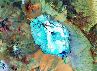
Pastos Grandes Lake is a lake in the Pastos Grandes caldera in the Potosí Department, Bolivia. At an elevation of 4,430 metres (14,530 ft), its surface area is 120 square kilometres (46 sq mi).

Tunupa is a dormant volcano in the Potosí Department of southwestern Bolivia.
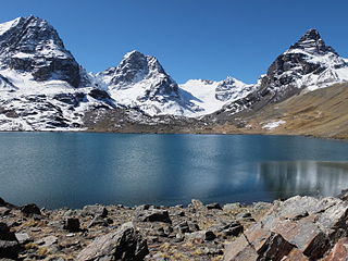
Ch'iyar Quta is a lake in the Cordillera Real of Bolivia situated in the La Paz Department, Los Andes Province, Pucarani Municipality, Huayna Potosí Canton. It is situated at a height of about 4,700 metres (15,400 ft) near the peaks of Kunturiri and east of the lake Juri Quta.

Kunturiri is a volcano in the Andes on the border of Bolivia and Chile which rises up to 5,762 metres (18,904 ft). On the Chilean side it is located in the Arica and Parinacota Region and on the Bolivian side in the Oruro Department, Sajama Province, Curahuara de Carangas Municipality, Sajama Canton as well as in the La Paz Department, Pacajes Province, Calacoto Municipality, Ulloma Canton.

Janq'u Quta is a lake in Bolivia located in the La Paz Department, Pedro Domingo Murillo Province, El Alto Municipality. It is situated south of the mountain Wayna Potosí and north-east of Milluni Lake at a height of about 4,664 metres (15,302 ft). The little lake north-east of Janq'u Quta is named Pata Quta (Pata Khota).
Wila Quta is a 5,032-metre-high (16,509 ft) mountain in the Cordillera Real in the Bolivian Andes. It is situated in the La Paz Department, Murillo Province, Palca Municipality. Wila Quta lies southwest of Mururata and Qutapata and northeast of Janq'u Qalani.
Juri Quta is a lake in the Cordillera Real of Bolivia located in the La Paz Department, Los Andes Province, Batallas Municipality, Turquia Canton. It lies north of the Kunturiri massif, south-east of Wila Lluxita and east of Wila Lluxi, at the feet of Mullu Apachita and Jisk'a Turini. Juri Quta is situated at a height of about 4,596 metres (15,079 ft), about 0,5 km long and 0,25 km at its widest point. The little lake north of Juri Quta is named Ch'uxña Quta.
Q'ara Quta is a lake on the western side of the Cordillera Real of Bolivia located in the La Paz Department, Los Andes Province, Batallas Municipality, Comunidad Alto Peñas. It lies north-west of the Kunturiri massif, between the lakes Wichhu Quta (5 km) in the south-west and Khotia Quta and Janq'u Quta in the north-east. The lakes are connected by Jach'a Jawira, a river which originates near the mountain Wila Lluxita and flows down to Lake Titicaca. Q'ara Quta is situated at a height of about 4,400 metres (14,400 ft), about 5 km long and 0,65 km at its widest point.
Jayu Qutta is a lake in the Oruro Department in Bolivia. It is situated west of Poopó Lake on the border of the sud Carangas Province and the Carangas Province. Ubicado en RosaPata Jayu Quta is about 3.4 km long and 2.5 km at its widest point.
Ch'uxña Quta is a mountain in the Bolivian Andes, about 4,920 metres (16,142 ft) high. It lies in the Kimsa Cruz mountain range, west of Wallatani Lake. It is situated in the La Paz Department, Loayza Province, Malla Municipality.
Ch'uxña Quta is a lake in the La Paz Department in Bolivia. It is situated in the Murillo Province, Palca Municipality. Ch'uxña Quta lies northeast of the mountain Tata Ch'iyar Qullu.
Wankar Quta Qullu is a mountain in the Andes of Bolivia, about 4,900 metres (16,076 ft) high. It is situated in the La Paz Department, Larecaja Province, Sorata Municipality, north of the main range of the Cordillera Real. Wankar Quta Qullu lies northeast of the mountain Wila Wilani. South of it there is a lake named Q'asiri Quta. A little river named Q'asiri Jawira originates here. It flows to Ch'uch'u Jawira in the south.
Maman Quta is a mountain in the Cordillera Real in the Bolivian Andes, about 5,160 metres (16,929 ft) high. It is situated in the La Paz Department, Murillo Province, La Paz Municipality. Mama Quta lies southeast of Qala Wathiyani.
Ch'iyar Qullu is a volcanic centre in Bolivia. It is located in the Oruro Department, Ladislao Cabrera Province, Salinas de Garci Mendoza Municipality, northeast of Salinas de Garci Mendoza, near a maar named Jayu Quta.
Wichhu Qullu (Aymara jichu, wichhustipa ichu, qullu mountain, "ichu mountain", also named Wichukkollu Loma is a mountain in a volcanic field in the Cordillera Occidental of Bolivia northeast of the summit of the Chullkani volcano. It is located in the Oruro Department, Sajama Province, Turco Municipality, between Jach'a K'uchu in the northeast and Liyun Ikiña in the southwest. The peak of Wichhu Qullu reaches a height of approximately 4,040 m.
Ch'iyar Quta is a mountain in the Bolivian Andes which reaches a height of approximately 4,280 m (14,040 ft). It is located in the La Paz Department, Loayza Province, Luribay Municipality. Ch'iyar Quta lies between the Ch'uñu Uma River in the north and the Ch'uñu Uma Jawira in the south which both originate southeast of the mountain. They flow to the Luribay River.
Quta K'uchu is a mountain in the La Paz Department in the Andes of Bolivia which reaches a height of approximately 4,820 m (15,810 ft). It is located in the Loayza Province, in the southeast of the Malla Municipality. Quta K'uchu lies southwest of Kimsa Willk'i.