Chipaya (village)

Last updated
Chipaya
Poblacion Chipaya.jpg
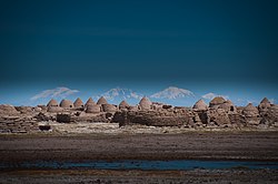
The ancient Chipaya village
Coordinates: 19°03′S68°05′W / 19.050°S 68.083°W / -19.050; -68.083
CountryBandera de Bolivia (Estado).svg  Bolivia
Department Oruro
Province Sabaya Province
Municipality Chipaya Municipality
Population
 (2001)
  Total363
Time zone UTC-4 (BOT)

Chipaya is a village in Bolivia located in the Sabaya Province (formerly Atahuallpa Province) of the Oruro Department. It is the seat of the Chipaya Municipality. In 2001 it had a population of 363. [1] The village is situated in a remote area northeast of Lake Coipasa [2] where the people have maintained special elements of their culture.

Contents

Chipaya was declared a National Monument by Supreme Decrete No. 8171 on December 7, 1967. [3]

Climate

Climate chart of the Sabaya Province in the Walter and Lieth format, metric, degCelsius und millimeters Klimadiagramm Sabaya.png
Climate chart of the Sabaya Province in the Walter and Lieth format, metric, °Celsius und millimeters

See also

Related Research Articles

Oruro Department Department of Bolivia

Oruro is a department in Bolivia, with an area of 53,588 km2 (20,690 sq mi). Its capital is the city of Oruro. According to the 2012 census, the Oruro department had a population of 494,178.

Arque Province Province in Cochabamba Department, Bolivia

Arque is a rural province in Cochabamba Department in the eastern cordillera of the South American state of Bolivia.

Mizque Province Province in Cochabamba, Bolivia

Mizque is a province in the Cochabamba Department, Bolivia. Its capital is Mizque.

Bautista Saavedra Province Province in La Paz Department, Bolivia

Bautista Saavedra is one of the twenty provinces of the Bolivian La Paz Department situated in the northwestern parts of the department. It was created on November 17, 1948 in honor of Bautista Saavedra Mallea (1870-1939) who was Bolivia's president from 1920 to 1925. The capital of the province is Charazani.

Villa Tunari Place in Cochabamba Department, Bolivia

Villa Tunari or Tunari is a location in the department of Cochabamba, Bolivia. It is the seat of the Villa Tunari Municipality, the third municipal section of the Chapare Province. According to the census 2012 the population was 3,213 in the town which is an increment from 2,510 registered during the 2001 census.

Sabaya Place in Oruro, Bolivia

Sabaya is a small town in the Bolivian Oruro Department. In 2001 it had a population of 573 inhabitants in 2001. Sabaya is the administrative center of the Sabaya Province and the Sabaya Municipality alike. It is located 200 km south-west of Oruro, the capital of the department. It is situated at 3,698 m above sea level in the valley of the Sabaya River on the eastern slopes of Pumari. Salar de Coipasa lies 25 km south-east of Sabaya, and the stratovolcano Tata Sabaya is situated 20 km south-west of Sabaya.

Federico Román Province

Federico Román is one of the five provinces of the Bolivian department of Pando and is situated in the department's northeastern parts. Its name honours General Federico Román.

Ichilo Province

Ichilo is one of the fifteen provinces of the Bolivian Santa Cruz Department and is situated in the department's north-western parts. The province was founded by a decree of 8 April 1926 and is named after Río Ichilo which is forming the province border in the West.

Tarata Municipality Municipality in Cochabamba Department, Bolivia

Tarata Municipality is the first municipal section of the Esteban Arce Province in the Cochabamba Department, Bolivia. Its capital is Tarata. At the time of census 2001 the municipality had 8,715 inhabitants. Along with neighboring municipalities such as Arbieto, Cliza, Tolata, and Punata, much of its population lives abroad, mainly in Argentina, Spain, Italy, and the Washington DC area in the United States.

Pocona Municipality Municipality in Cochabamba Department, Bolivia

Pocona Municipality is the third municipal section of the Carrasco Province in the Cochabamba Department in Bolivia. Its seat is Pocona. At the time of census 2001 the municipality had 13,488 inhabitants.

Tiwanaku Municipality Municipality in La Paz Department, Bolivia

Tiwanaku Municipality is the third municipal section of the Ingavi Province in the La Paz Department, Bolivia. Its seat is the village of Tiwanaku located near the UNESCO World Heritage Site Tiwanaku.

Pocona is a location in the Cochabamba Department in central Bolivia. It is the seat of the Pocona Municipality, the third municipal section of the Carrasco Province. At the time of census 2001 it had a population of 244.

Anzaldo Municipality is the second municipal section of the Esteban Arce Province in the Cochabamba Department, Bolivia. Its seat is Anzaldo. At the time of census 2001 the municipality had 9,126 inhabitants.

Arque Municipality is the first municipal section of the Arque Province in the Cochabamba Department, Bolivia. Its seat is Arque. At the time of census 2001 the municipality had 11,806 inhabitants. It has the lowest HDI of Bolivia with 0.311.

Tacachi Municipality Municipality in Cochabamba Department, Bolivia

Tacachi Municipality is the fourth municipal section of the Punata Province in the Cochabamba Department in Bolivia. Its seat is Tacachi.

Tacopaya Municipality is the second municipal section of the Arque Province in the Cochabamba Department in Bolivia. Its seat is Tacopaya. At the time of census 2001 the municipality had 11,658 inhabitants.

San José is a small town in the Santa Cruz Department in the South American Andean Republic of Bolivia.

Cotoca Town in Santa Cruz Department, Bolivia

Cotoca is a canton and Municipality of Andrés Ibáñez Province in Santa Cruz Department, Bolivia. The municipality consists of two cantons – Cotoco itself and Puerto Pailas. In 2010 it had an estimated population of 23,951 for the canton and 56,451 for the municipality.

Atocha Municipality Municipality in Potosí Department, Bolivia

Atocha Municipality is the second municipal section of the Sud Chichas Province in the Potosí Department in Bolivia. Its seat is Atocha. It is located within the Andes mountain range.

References

  1. National Institute of Statistics (INE) 2001 Archived 2014-02-21 at the Wayback Machine
  2. ine.gob.bo/publicaciones/ Archived 2014-02-21 at the Wayback Machine Chipaya Municipality: Population data and map
  3. bolivia.com Viceministerio de Desarollo de las Culturas, Bolivia, Patrimonio Cultural, Monumentos Nacionales Declarados por el Estado Boliviano: "Pueblo y Parroquia de Chipaya"