Sabaya is a province in the central parts of the Bolivian Oruro Department. Its seat is Sabaya.

Litoral is a province in the southwestern parts of the Bolivian Oruro Department. Its seat is Huachacalla.

Poopó is a province in the eastern parts of the Bolivian department of Oruro. Its seat is Poopó.

Puerto de Mejillones is a province in the western parts of the Bolivian department of Oruro. It is one of the sixteen provinces in the Oruro Department. Its seat is La Rivera.
Sajama is a province in the northwestern parts of the Bolivian Oruro Department.

Salinas de Garci Mendoza is a town in the Bolivian Oruro Department. It is the administrative center of Ladislao Cabrera Province and is located 280 km (170 mi) south-west of Oruro, the capital of the department. It is situated at an elevation of 3,732 m (12,244 ft) at Caricha, 20 km north of the Tunupa stratovolcano. Salar de Coipasa,a salt lake, is 20 km north-west of Salinas de Garci Mendoza, and 15 km in south-eastern direction is Salar de Uyuni, the world's largest salt pan. Salinas de Garci Mendoza is the endpoint of the road from Chuquichamba via Andamarca and Aroma to Salinas de Garci Mendoza.

Turco Municipality is the second municipal section of the Sajama Province in the Oruro Department in Bolivia, and was founded on February 15, 1957. Its seat is Turco, situated 154 km west of Oruro at an altitude of 3,860 m. The municipality covers an area of 3,973 km², not taking into account the area of Laca Laca Canton.

Lago Coipasa or Salar de Coipasa is a lake in Sabaya Province, Oruro Department, Bolivia. At an elevation of 3657 m, its surface area is 806 km². It is on the western part of Altiplano, 20 km north of Salar de Uyuni and south of the main road linking Oruro and Huara (Chile).
Toledo (Oruro) is a small town in Bolivia. Toledo is the administrative seat of Saucarí Province, as well as that of Toledo Municipality. The town lies at an elevation of 3,715 metres (12,188 ft) between Río Laq'a Jawira in the west and Río Vinto Jahuira in the east, both of which drain into Lake Poopó.

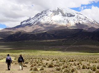
Pukintika is a volcano in the Andes, about 5,407 m (17,740 ft) high, situated in the Cordillera Occidental on the border of Bolivia and Chile. It is located in the Arica and Parinacota Region of Chile and the Oruro Department of Bolivia. Pukintika lies to the north of the Salar de Surire, east beside Arintika volcano which is younger than Pukintika. Pukintika also features a crater lake with a surface area of 2,500 square metres (27,000 sq ft). Deposits of elemental sulfur have been found on Pukintika.
Wila Qullu is a mountain in the Bolivian Andes, about 4,600 metres (15,092 ft) high. It situated in the Cordillera Occidental near the border with Chile. It is located in the Oruro Department, Sabaya Province, Sabaya Municipality, Julo Canton. Wila Qullu lies south-east of the volcano Pukintika and north-west of the mountain Phaq'u Q'awa.
Kimsa Chata is a 5,245-metre-high (17,208 ft) mountain in the Andes of Bolivia. It is located in the Oruro Department, Sabaya Province, Sabaya Municipality, Negrillos Canton. It lies south-east of the mountain Qillwiri, east of Lliscaya, north-east of Taypi Qullu and north-west of the Laram Pukara, near the border with Chile.
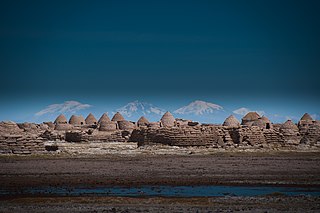
Chipaya is a village in Bolivia located in the Sabaya Province of the Oruro Department. It is the seat of the Chipaya Municipality. In 2001 it had a population of 363. The village is situated in a remote area northeast of Lake Coipasa where the people have maintained special elements of their culture.
Taypi Qullu is a mountain in the Cordillera Occidental in the Andes of Bolivia, about 4,600 metres (15,092 ft) high. It is located in the Oruro Department, Sabaya Province, Sabaya Municipality, Parajaya Canton, near the border with Chile. Taypi Qullu lies south-east of the mountain Lliscaya and south-west of the mountains Laram Pukara and Kimsa Chata.
P'iq'iñ Q'ara is a 4,763-metre-high (15,627 ft) mountain in the Cordillera Occidental in the Andes of Bolivia. It is located in the Oruro Department, Sabaya Province, Sabaya Municipality. P'iq'iñ Q'ara is situated south-west of the mountain Kimsa Chata, near the border with Chile. It lies at the confluence of the rivers Chullumpiri Jawira and Lliscaya Jawira.
Qillwiri is a mountain in the Andes on the border of Bolivia and Chile. On the Chilean side it is located in the Arica y Parinacota Region. It is situated in the Cordillera Occidental between the mountains Pukintika in the north-west and Lliscaya in the south-east, east of the Suriri salt flat. On the Bolivian side the mountain lies in the Oruro Department, Sabaya Province, Sabaya Municipality.
Jinchupalla is a 4,189-metre-high (13,743 ft) mountain in the Andes of Bolivia. It is located in the Oruro Department, Sabaya Province, Sabaya Municipality, south of the Lauca River.
Phaq'u Q'awa is a 5,203-metre-high (17,070 ft) mountain in the Cordillera Occidental in the Andes of Bolivia. It is situated in the Oruro Department, Sabaya Province, Sabaya Municipality. Phaq'u Q'awa lies southeast of Wila Qullu.

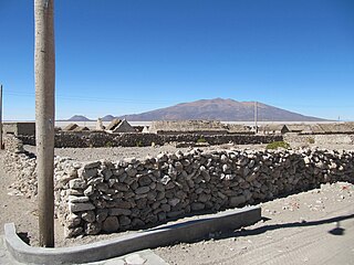
Tata Sabaya is a 5,430-metre (17,810 ft) high volcano in Bolivia. It is part of the Central Volcanic Zone, one of several volcanic belts in the Andes which are separated by gaps without volcanic activity. This section of the Andes was volcanically active since the Jurassic, with an episode of strong ignimbritic volcanism occurring during the Miocene. Tata Sabaya lies in a thinly populated region north of the Salar de Coipasa salt pan.

