
Salar de Uyuni is the world's largest salt flat, or playa, at over 10,000 square kilometres (3,900 sq mi) in area. It is in the Daniel Campos Province in Potosí in southwest Bolivia, near the crest of the Andes at an elevation of 3,656 m (11,995 ft) above sea level.

Oruro or Uru Uru is a city in Bolivia with a population of 264,683, about halfway between La Paz and Sucre in the Altiplano, approximately 3,709 meters (12,169 ft) above sea level.
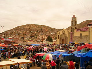
Oruro is a department of Bolivia, with an area of 53,588 km2 (20,690 sq mi). Its capital is the city of Oruro. According to the 2012 census, the Oruro department had a population of 494,178.

The Altiplano, Collao or Andean Plateau, in west-central South America, is the most extensive high plateau on Earth outside Tibet. The plateau is located at the latitude of the widest part of the north–south-trending Andes. The bulk of the Altiplano lies in Bolivia, but its northern parts lie in Peru, and its southwestern fringes lie in Chile.

Lake Poopó was a large saline lake in a shallow depression in the Altiplano Mountains in Oruro Department, Bolivia, at an altitude of approximately 3,700 m (12,100 ft). Due to the lake's length and width, it made up the eastern half of Oruro, known as a mining region in southwest Bolivia. The permanent part of the lake body covered approximately 1,000 square kilometres (390 sq mi) and it was the second-largest lake in the country. The lake received most of its water from the Desaguadero River, which flows from Lake Titicaca at the north end of the Altiplano. Since the lake lacked any major outlet and had a mean depth of less than 3 m (10 ft), the surface area differed greatly seasonally.

Daniel Campos is a province in the north-western parts of the Bolivian Potosí Department. It is named after the poet Daniel Campos who originated from this area. The capital of the province is Llica.
Sabaya is a province in the central parts of the Bolivian Oruro Department. Its seat is Sabaya.
Chipaya is a native South American language of the Uru–Chipaya language family. The only other language in the grouping, Uru, is considered by some to be a divergent dialect of Chipaya. Ethnologue lists the language vitality as "vigorous," with 1,800 speakers out of an ethnic population of around 2,100, although younger generations speak it progressively less. Chipaya has been influenced considerably by Aymara, the Quechuan languages, and more recently, Spanish, with a third of its vocabulary having been replaced by those languages.
Salinas de Garci Mendoza is a town in the Bolivian Oruro Department. It is the administrative center of Ladislao Cabrera Province and is located 280 km (170 mi) south-west of Oruro, the capital of the department. It is situated at an elevation of 3,732 m (12,244 ft) at Caricha, 20 km north of the Tunupa stratovolcano. Salar de Coipasa,a salt lake, is 20 km north-west of Salinas de Garci Mendoza, and 15 km in south-eastern direction is Salar de Uyuni, the world's largest salt pan. Salinas de Garci Mendoza is the endpoint of the road from Chuquichamba via Andamarca and Aroma to Salinas de Garci Mendoza.

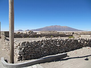
Sabaya is a small town in the Bolivian Oruro Department. In 2001 it had a population of 573 inhabitants in 2001. Sabaya is the administrative center of the Sabaya Province and the Sabaya Municipality alike. It is located 200 km (120 mi) south-west of Oruro, the capital of the department. It is situated at 3,698 m (12,133 ft) above sea level in the valley of the Sabaya River on the eastern slopes of Pumari (4,787 m [15,705 ft]). Salar de Coipasa lies 25 km (16 mi) south-east of Sabaya, and the stratovolcano Tata Sabaya (5,430 m [17,810 ft]) is situated 20 km (12 mi) south-west of Sabaya.

Tourism in Bolivia is one of the economic sectors of the country. According to data from the National Institute of Statistics of Bolivia (INE), there were over 1.24 million tourists that visited the country in 2020, making Bolivia the ninth most visited country in South America. the Bolivia is a country with great tourism potential, with many attractions, due to its diverse culture, geographic regions, rich history and food. In particular, the salt flats at Uyuni are a major attraction.
Laq'a Jawira is a river in Bolivia which runs from Lake Poopó. Its length is entirely within the territory of Oruro Department.

Jayu Quta is a maar partially filled with water, in the Bolivian Altiplano, north of the Salar de Uyuni and east of the Salar de Coipasa. It is situated in the Oruro Department, Ladislao Cabrera Province, Salinas de Garci Mendoza Municipality, Villa Esperanza Canton. It was originally misidentified as a meteorite impact crater.

Chipaya is a village in Bolivia located in the Sabaya Province of the Oruro Department. It is the seat of the Chipaya Municipality. In 2001 it had a population of 363. The village is situated in a remote area northeast of Lake Coipasa where the people have maintained special elements of their culture.

Paryani is a 5,077-metre-high (16,657 ft) volcano in the Andes of Bolivia. It is located in the Oruro Department, Sabaya Province, Sabaya Municipality. The cone of Paryani lies at the Salar de Coipasa, south of Pumiri and east of Tata Sabaya.

Lake Tauca is a former lake in the Altiplano of Bolivia. It is also known as Lake Pocoyu for its constituent lakes: Lake Poopó, Salar de Coipasa and Salar de Uyuni. The lake covered large parts of the southern Altiplano between the Eastern Cordillera and the Western Cordillera, covering an estimated 48,000 to 80,000 square kilometres of the basins of present-day Lake Poopó and the Salars of Uyuni, Coipasa and adjacent basins. Water levels varied, possibly reaching 3,800 metres (12,500 ft) in altitude. The lake was saline. The lake received water from Lake Titicaca, but whether this contributed most of Tauca's water or only a small amount is controversial; the quantity was sufficient to influence the local climate and depress the underlying terrain with its weight. Diatoms, plants and animals developed in the lake, sometimes forming reef knolls.
Ouki was an ancient lake in the Bolivian Altiplano. Its existence was postulated in 2006 by a group of scientists who had subdivided the Lake Minchin lake cycle into several lake phases. The Lake Minchin cycle had been previously identified in 1904 as a now disappeared lake in the central Altiplano. Sediments attributed to Lake Minchin may rather be part of Ouki. The dating is uncertain, with radiocarbon and uranium-thorium dating yielding different dates spanning the time between 28,200 and 125,990 ± 9,580 years ago.
Sajsi is the name of an ancient lake in the Andes

Tata Sabaya is a 5,430-metre (17,810 ft) high volcano in Bolivia. It is part of the Central Volcanic Zone, one of several volcanic belts in the Andes which are separated by gaps without volcanic activity. This section of the Andes was volcanically active since the Jurassic, with an episode of strong ignimbritic volcanism occurring during the Miocene. Tata Sabaya lies in a thinly populated region north of the Salar de Coipasa salt pan.
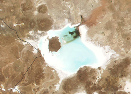
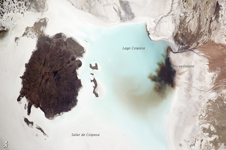
Coipasa is a rural municipality in Sabaya Province, Oruro Department, Bolivia. It is surrounded by Coipasa Lake on three directions, and has an average elevation of 3,709 meters above the sea level.


