Tata Sabaya

Last updated • 7 min readFrom Wikipedia, The Free Encyclopedia

Tata Sabaya
ISS-35 Tata Sabaya Volcano.jpg
Highest point
Elevation 5,430 m (17,810 ft) [1]
Coordinates 19°08′S68°32′W / 19.133°S 68.533°W / -19.133; -68.533 [2]
Geography
Bolivia physical map.svg
Red triangle with thick white border.svg
Tata Sabaya

Tata Sabaya is a 5,430-metre (17,810 ft) high volcano in Bolivia. It is part of the Central Volcanic Zone, one of several volcanic belts in the Andes which are separated by gaps without volcanic activity. This section of the Andes was volcanically active since the Jurassic, with an episode of strong ignimbritic volcanism occurring during the Miocene. Tata Sabaya lies in a thinly populated region north of the Salar de Coipasa salt pan.

Contents

Volcanic activity at Tata Sabaya and elsewhere in the Central Volcanic Zone is the consequence of the subduction of the Nazca Plate beneath the South America Plate. The volcano has developed along a lineament that separates older crust north of the lineament from younger crust in the south, and the edifice has been formed by andesitic rocks.

The southern flank of Tata Sabaya failed during the latest Pleistocene about 12,000–12,360 years before present. Debris from the collapse entered a lake that covered the Salar de Coipasa at that time and formed a deposit with a volume of 6 ± 1 cubic kilometre (1.44 ± 0.24 cu mi). Subsequently, the collapse scar was partly filled in with more recent lava flows and lava domes; one eruption occurred about 6,000 years before present.

Geography and geomorphology

Tata Sabaya lies just north of the Salar de Coipasa in Bolivia. The small village of Pagador lies west-southwest of the volcano, [3] but the whole region is overall thinly inhabited. [4] The name means "Father Sabaya"; the term "Sabaya" may be the Aymara corruption of the Quechua term for "devil", "demon". [5] The volcano, which features a summit sanctuary, [6] is a topic in local myths, where it is sometimes personified, [7] and subject of a ritual involving it and neighbouring volcanoes. [8]

Tata Sabaya is part of the Central Volcanic Zone of the Andes, [9] which consists of a volcanic arc that mainly follows the Western Cordillera. There are about 44 Holocene volcanoes, however the remoteness of the region and dry climate has restricted scientific research of these volcanoes; among the better known are Lastarria, the Nevados de Payachata, Ollagüe, San Pablo, San Pedro and Socompa. [2]

Tata Sabaya is a volcano which reaches a height of 5,430 metres (17,810 ft). [1] [10] Five lava flows extend north from the summit and display levees and flow fronts, the flows reaching a maximum length of 2 kilometres (1.2 mi). The top of these flows is cut by a collapse scar that extends east and west of the edifice in the form of scarps up to 50 metres (160 ft) high. [11] The space between the scarps is in turn filled by more recent lava flows with a blocky appearance. [12] Farther away of the edifice, the scarp is more noticeable and reaches a height of about 200 metres (660 ft) on the southeastern side of the volcano. [10]

A 300-square-kilometre (120 sq mi) large deposit south of the volcano, originally interpreted as a nuee ardente deposit, is actually a landslide deposit [2] which extends over a length of 20 kilometres (12 mi) and a width of 7 kilometres (4.3 mi); [13] its volume is about 6 ± 1 cubic kilometre (1.44 ± 0.24 cu mi). [14] The landslide incorporated material from the salar, [15] and its rocks reflect in part the layering and structure of the pre-collapse volcano. [14] The deposit is one of the more conspicuous of its type, to the point that it was observed and identified on low-resolution Landsat images. [10] It consists of material that forms hummock-like deposits, with individual hummocks becoming smaller the farther away from the edifice they are. [11] The deposit extends into the Salar de Coipasa where it is confined by faults [13] and is in part covered by lacustrine sediments such as tufa. [11]

Geology

Off the western coast of South America, the Nazca Plate subducts beneath the South America Plate [16] at a rate of about 10 centimetres per year (3.9 in/year). [17] This subduction process is responsible for the volcanism in the Andean Volcanic Belt, which occurs in a Northern Volcanic Zone in Ecuador and Colombia, a Central Volcanic Zone in Peru, Bolivia, Chile and Argentina and a Southern Volcanic Zone in Chile and Argentina. These volcanic zones are separated by gaps without volcanism, where the subduction process is shallower. [18]

Several phases of tectonic and volcanic activity have been identified in the Central Volcanic Zone. An earlier phase of volcanism in the Cordillera de la Costa commenced in the Jurassic but is considered separate from the Central Volcanic Zone magmatism proper. After an erosional hiatus during the Oligocene, volcanic arc activity increased during the Miocene and culminated in a phase of strong ignimbrite eruptions, [9] which originated in calderas. This phase was associated with a substantial thickening of the crust in the Central Andes. During the Pleistocene ignimbrite volcanism waned again and stratovolcanoes began to develop. [2]

Tata Sabaya lies along a crustal transition area which separates a younger crust farther south from an older (Proterozoic) crust in the north, [2] which is made up by the Chilenia terrane and the Arequipa-Antofalla craton, respectively. This transition area appears to coincide with a chain of volcanoes that Tata Sabaya is part of and which extends from Cerro Saxani in the east to Isluga in Chile, as well as with the northern end of the Pica gap where no recent volcanism occurs in the volcanic arc. [17]

The basement of the volcano is formed by the ignimbritic Altos de Pica formation, although outcrops of granite have been observed in the region; [17] one of these outcrops may be a Precambrian granite subsequently thermally modified in the Toarcian. [19] This basement is covered by younger volcanic rocks, alluvium and sediments of the Salar de Coipasa. Seismic tomography suggests that molten magma exists in the regional crust. [17]

Composition

Tata Sabaya has produced "two-pyroxene" andesite and porphyritic andesite. [20] Minerals contained within the rock are augite, biotite, hornblende, hypersthene, plagioclase and titanomagnetite with only little variation between rocks erupted during separate stages of volcanic activity. [21] The erupted volcanites define a potassium-rich calc-alkaline suite. Inclusions of more mafic [a] rocks in the erupted material may indicate that mafic magma was injected into the magma chamber of Tata Sabaya. [12] The magma genesis at Tata Sabaya has been explained with magma mixing processes, which gave rise to a fairly uniform composition of the eruption products. [23]

Climate and vegetation

The region is dry with precipitation mainly falling during southern hemisphere summer, and has little vegetation cover. [4] Polylepis tarapacana trees grow on the slopes of Tata Sabaya; these trees form the highest woodlands in the world. [24] Other aspects of regional vegetation are the so-called puna steppe, which is characterized by grass and shrub vegetation. [25]

Eruption history

Of all volcanoes in Bolivia, Tata Sabaya is the only one with Holocene activity which is not on the border with another country. [2] The young age of the mountain has been inferred from the lack of glaciation [1] and moraines on the mountain, [10] unlike neighbouring summits. [1]

The earliest activity at Tata Sabaya constructed a pyroclastic shield, which crops out as a 20-metre (66 ft) thick sequence of block-and-ash flows fallout deposits and pumice deposits in the northern sector of the volcano. [17] Effusive eruptions then built up a volcanic cone on top of this shield; the five northerly lava flows were emplaced during this phase of activity. Some lava flows from this stage were unstable and collapsed, covering the northern parts of the volcano with debris. [26]

This effusive activity eventually oversteepened the cone, causing its southern sector to collapse. During this collapse and landsliding, large toreva blocks developed from sectors of the cone which slid down undeformed, while other material from the cone formed the hummocks in the sector collapse deposit; [11] there was no explosive eruption at the time of the collapse. The configuration of the deposit indicates that the debris entered the Salar when it was filled with water; the height of the tufa deposits imply that water levels were about 3,700 metres (12,100 ft) above sea level. This [12] and the lake terraces that the landslide overran marks the collapse as synchronous with the Lake Tauca episode 12,000-12,360 years ago [12] [10] when water levels in the Salar de Coipasa reached their maximum. [27] The onset of such collapses on volcanoes is often determined by faulting, climate change or eruption of the volcano; at Tata Sabaya earthquakes and the injection of new magma has been invoked to explain the destabilization of the edifice. [14]

After the collapse, Holocene activity filled the scar with lava domes and lava flows, cancelling the traces of the collapse; [27] some of these in turn collapsed as well and gave rise to hot avalanche deposits. [12] Radiocarbon dating for a pyroclastic flow has yielded an age of 6,000 years before present, implying that the volcano may be still active. [28] Reportedly, when in 1600 Huaynaputina erupted in Peru a volcano named Sabaya erupted in Oruro and destroyed a village. [29]

Notes

  1. A volcanic rock relatively rich in iron and magnesium, relative to silicium. [22]

Related Research Articles

<span class="mw-page-title-main">Parinacota (volcano)</span> Volcano on the border of Chile and Bolivia

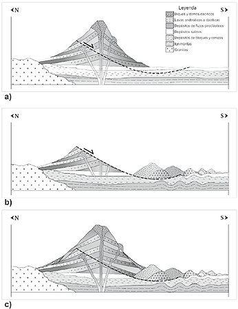
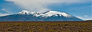
Parinacota, Parina Quta or Parinaquta is a dormant stratovolcano on the border of Bolivia and Chile. Together with Pomerape it forms the Nevados de Payachata volcanic chain. Part of the Central Volcanic Zone of the Andes, its summit reaches an elevation of 6,380 metres (20,930 ft) above sea level. The symmetrical cone is capped by a summit crater with widths of 1 kilometre (0.62 mi) or 1,000 metres (3,300 ft). Farther down on the southern slopes lie three parasitic centres known as the Ajata cones. These cones have generated lava flows. The volcano overlies a platform formed by lava domes and andesitic lava flows.

<span class="mw-page-title-main">Lascar (volcano)</span> A stratovolcano within the Central Volcanic Zone of the Andes

Lascar is a stratovolcano in Chile within the Central Volcanic Zone of the Andes, a volcanic arc that spans Peru, Bolivia, Argentina and Chile. It is the most active volcano in the region, with records of eruptions going back to 1848. It is composed of two separate cones with several summit craters. The westernmost crater of the eastern cone is presently active. Volcanic activity is characterized by constant release of volcanic gas and occasional vulcanian eruptions.

<span class="mw-page-title-main">Nevado de Longaví</span> Volcano in Chile

Nevado de Longaví is a volcano in the Andes of central Chile. The 3,242 m (10,636 ft) high volcano lies in the Linares Province, which is part of the Maule Region. It features a summit crater and several parasitic vents. The volcano is constructed principally from lava flows. Two collapses of the edifice have carved collapse scars into the volcano, one on the eastern slope known as Lomas Limpias and another on the southwestern slope known as Los Bueye. The volcano features a glacier and the Achibueno and Blanco rivers originate on the mountain.

<span class="mw-page-title-main">Isluga</span> Mountain in Chile

Isluga is a stratovolcano located in Colchane, 7 kilometres (4.3 mi) west of the Chile-Bolivia border and at the west end of a group of volcanoes lined up in an east-west direction, which also includes the volcanoes Cabaray and Tata Sabaya. Isluga has an elongated summit area and lies within the borders of Volcán Isluga National Park in Chile's Tarapacá Region.

<span class="mw-page-title-main">Ollagüe</span> Stratovolcano in Bolivia and Chile

Ollagüe or Ullawi is a massive andesite stratovolcano in the Andes on the Bolivia–Chile border, within the Antofagasta Region of Chile and the Potosi Department of Bolivia. Part of the Central Volcanic Zone of the Andes, its highest summit is 5,868 metres (19,252 ft) above sea level and features a summit crater that opens to the south. The western rim of the summit crater is formed by a compound of lava domes, the youngest of which features a vigorous fumarole that is visible from afar.

<span class="mw-page-title-main">Purico complex</span> Pleistocene volcanic complex in Chile

The Purico complex is a Pleistocene volcanic complex in Chile close to Bolivia, formed by an ignimbrite, several lava domes and stratovolcanoes and one maar. It is in the Chilean segment of the Central Volcanic Zone, one of the four volcanic belts which make up the Andean Volcanic Belt. The Central Volcanic Zone spans Peru, Bolivia, Chile and Argentina and includes 44 active volcanoes as well as the Altiplano–Puna volcanic complex, a system of large calderas and ignimbrites of which Purico is a member. Licancabur to the north, La Pacana southeast and Guayaques to the east are separate volcanic systems.

<span class="mw-page-title-main">San Pedro (Chile volcano)</span> One of the tallest active volcanoes in the world

San Pedro is a Holocene composite volcano in northern Chile and at 6,155 metres (20,194 ft) in elevation one of the highest active volcanoes in the world. Part of the Chilean Andes' volcanic segment, it is part of the Central Volcanic Zone of the Andes, one of the four tracts of the Andean Volcanic Belt. This region of volcanism includes the world's two highest volcanoes Ojos del Salado and Llullaillaco. San Pedro, like other Andean volcanoes, was formed by the subduction of the Nazca Plate beneath the South America Plate. It has a neighbouring volcano, San Pablo, and is itself formed by two separate edifices usually known as the Old Cone and the Young Cone. These edifices are formed by rocks ranging from basaltic andesite over andesite to dacite and are emplaced on a basement formed by Miocene volcanic rocks.

<span class="mw-page-title-main">Taapaca</span> Volcano in Chile

Taapaca is a Holocene volcanic complex in northern Chile's Arica y Parinacota Region. Located in the Chilean Andes, it is part of the Central Volcanic Zone of the Andean Volcanic Belt, one of four distinct volcanic chains in South America. The town of Putre lies at the southwestern foot of the volcano.

<span class="mw-page-title-main">Volcán Putana</span> Mountain in Chile

Volcán Putana, sometimes referred to as Jorqencal or Machuca, is a stratovolcano located In the Central Volcanic Zone (CVZ) of the Andes on the border between Bolivia and Chile and close to the Sairecabur volcanic complex. Its summit is 5,884 metres (19,304 ft) above sea level and contains a summit crater with two smaller craters nested within it. Beneath the summit, the volcano features a number of lava domes and lava flows, some of which originated in flank vents.

<span class="mw-page-title-main">La Pacana</span> Large Miocene-age caldera in northern Chile

La Pacana is a Miocene age caldera in northern Chile's Antofagasta Region. Part of the Central Volcanic Zone of the Andes, it is part of the Altiplano-Puna volcanic complex, a major caldera and silicic ignimbrite volcanic field. This volcanic field is located in remote regions at the Zapaleri tripoint between Chile, Bolivia and Argentina.

<span class="mw-page-title-main">Jayu Quta (Ladislao Cabrera)</span> Crater in Bolivia

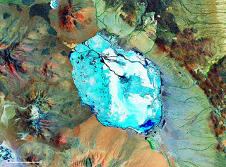
Jayu Quta is a maar partially filled with water, in the Bolivian Altiplano, north of the Salar de Uyuni and east of the Salar de Coipasa. It is situated in the Oruro Department, Ladislao Cabrera Province, Salinas de Garci Mendoza Municipality, Villa Esperanza Canton. It was originally misidentified as a meteorite impact crater.

<span class="mw-page-title-main">El Negrillar</span> Volcanic field in the Andes

El Negrillar is a volcanic field in the Andes. Located south of the Salar de Atacama and west of the Cordón de Púlar, it generated cinder cones and lava flows. Covering a surface area of 220 square kilometres (85 sq mi), it is the largest volcanic field in northern Chile, with almost a hundred vents that produced mainly lava flows. Owing to the arid climate, landforms are well preserved. Radiometric dating has yielded ages of less than 1.5 million years, with the most recent eruption occurring about 141,000 years ago. Parts of the Holocene Socompa debris avalanche overlie the field. A groundwater system underlies the volcanic field and some cones formed through phreatomagmatic eruptions. El Negrillar is located in a complex tectonic regime, characterized by numerous faults. The town of Tilomonte and various power lines, mines and water wells are in the area.

<span class="mw-page-title-main">Incapillo</span> Pleistocene caldera in Argentina

Incapillo is a Pleistocene-age caldera in the La Rioja Province of Argentina. It is the southernmost volcanic centre in the Andean Central Volcanic Zone (CVZ) that erupted during the Pleistocene. Incapillo is one of several ignimbrite or caldera systems that, along with 44 active stratovolcanoes, comprise the CVZ.

Irruputuncu is a volcano in the commune of Pica, Tamarugal Province, Tarapacá Region, Chile, as well as San Pedro de Quemes Municipality, Nor Lípez Province, Potosí Department, Bolivia. The mountain's summit is 5,163 m (16,939 ft) high and has two summit craters—the southernmost 200 m (660 ft)-wide one has active fumaroles. The volcano also features lava flows, block and ash flows and several lava domes. The volcano is part of the Andean Central Volcanic Zone (CVZ).

<span class="mw-page-title-main">Lastarria</span> Stratovolcano on the border between Chile and Argentina

Lastarria is a 5,697 metres (18,691 ft) high stratovolcano that lies on the border between Chile and Argentina. It is remote, and the surroundings are uninhabited but can be reached through an unpaved road. The volcano is part of the Central Volcanic Zone, one of the four segments of the volcanic arc of the Andes. Over a thousand volcanoes—of which about 50 are active—lie in this over 1,500 kilometres (930 mi) long chain of volcanoes, which is generated by subduction of the Nazca Plate beneath the South American Plate.

<span class="mw-page-title-main">Olca-Paruma</span> Volcanic complex in Chile

Olca-Paruma is a volcanic complex in Chile. Lying on the border between Chile and Bolivia, it is formed by an east–west alignment of volcanoes. From west to east, these are Cerro Paruma, Volcan Paruma, Olca, and Mencheca or Michincha. Aside from the mines of Ujina, Rosario, and Quebrada Blanca, the area is sparsely populated.

<span class="mw-page-title-main">Pastos Grandes</span> Caldera and its crater lake in Bolivia

Pastos Grandes is the name of a caldera and its crater lake in Bolivia. The caldera is part of the Altiplano-Puna volcanic complex, a large ignimbrite province that is part of the Central Volcanic Zone of the Andes. Pastos Grandes has erupted a number of ignimbrites through its history, some of which exceeded a volume of 1,000 cubic kilometres (240 cu mi). After the ignimbrite phase, the lava domes of the Cerro Chascon-Runtu Jarita complex were erupted close to the caldera and along faults.

<span class="mw-page-title-main">Antofalla</span> Mountain in Argentina

Antofalla is a Miocene-Pliocene volcano in Argentina's Catamarca Province. It is part of the volcanic segment of the Andes in Argentina, and it is considered to be part of the Central Volcanic Zone, one of the volcanic zones of the Andes. Antofalla forms a group of volcanoes that are aligned on and behind the main volcanic arc. Antofalla itself is a remote volcano.

<span class="mw-page-title-main">Tocorpuri</span> Volcano in Bolivia and Chile

Tocorpuri is a volcano in Chile, close to the border with Bolivia. Its peak height is most recently given as 5,808 metres (19,055 ft) and it features a 1.3 kilometres (0.81 mi) wide summit crater. The volcano consists mainly of lava flows and pyroclastic deposits and is subdivided into two separate edifices. Just west of Tocorpuri, the La Torta lava dome is a 200 metres (660 ft) high flat-topped structure. The volcanoes are formed by andesitic, dacitic and rhyolitic rocks.

<span class="mw-page-title-main">Cerro Panizos</span> Late Miocene caldera in Bolivia and Argentina

Cerro Panizos is a late Miocene-age shield-shaped volcano spanning the Potosi Department of Bolivia and the Jujuy Province of Argentina. It features two calderas and a group of lava domes. It is part of the Altiplano-Puna volcanic complex (APVC), a group of calderas and associated ignimbrites that erupted during the past ten million years. Cerro Panizos is part of the Central Volcanic Zone (CVZ), a volcanic arc that extends from Peru to Chile which was formed mostly by subduction of the Nazca Plate beneath South America.

References

  1. 1 2 3 4 de Silva et al. 1993, p. 308.
  2. 1 2 3 4 5 6 de Silva et al. 1993, p. 307.
  3. de Silva et al. 1993, p. 307,308.
  4. 1 2 Banks, David; Markland, Howard; Smith, Paul V.; Mendez, Carlos; Rodriguez, Javier; Huerta, Alonso; Sæther, Ola M. (June 2005). "The effect of filtration on analyses of surface water samples. A study from the Salars of Coipasa and Uyuni, Bolivian Altiplano". Journal of Geochemical Exploration. 86 (2): 107. doi:10.1016/j.gexplo.2005.04.003. ISSN   0375-6742.
  5. Holmer, Nils M. (19 July 2013). "Indian Place Names in South America and the Antilles. II". Names. 8 (4): 204. doi:10.1179/nam.1960.8.4.197.
  6. Reinhard 1983, p. 32.
  7. Gisbert, Teresa (1994). "El señorío de los Carangas y los chullpares del Río Lauca" (PDF) (in Spanish). Centro Bartolome de Las Casas. p. 433. Retrieved 7 February 2018.
  8. Reinhard 1983, p. 41.
  9. 1 2 de Silva et al. 1993, p. 306.
  10. 1 2 3 4 5 Francis, P. W.; Wells, G. L. (1 July 1988). "Landsat Thematic Mapper observations of debris avalanche deposits in the Central Andes". Bulletin of Volcanology. 50 (4): 265. Bibcode:1988BVol...50..258F. doi:10.1007/BF01047488. ISSN   0258-8900. S2CID   128824938.
  11. 1 2 3 4 de Silva et al. 1993, p. 313.
  12. 1 2 3 4 5 de Silva et al. 1993, p. 315.
  13. 1 2 Deruelle, B.; Brousse, R. (2010). ""Nuee ardente" deposits at Tata Sabaya volcano (Bolivian-Chilean Andes): Pumices and lava blocks crystallization from single magma at different depths". Revista Geológica de Chile (in Spanish) (22).
  14. 1 2 3 Godoy, Benigno; Clavero, Jorge; Rojas, Constanza; Godoy, Estanislao (2012). "Facies volcánicas del depósito de avalancha de detritos del volcán Tata Sabaya, Andes Centrales". Andean Geology (in Spanish). 39 (3): 394–406. doi: 10.5027/andgeoV39n3-a03 . ISSN   0718-7106.
  15. Clavero et al. 2006, p. 442.
  16. de Silva et al. 1993, p. 305.
  17. 1 2 3 4 5 de Silva et al. 1993, p. 309.
  18. de Silva et al. 1993, p. 305,306.
  19. Sempere, Thierry; Carlier, Gabriel; Soler, Pierre; Fornari, Michel; Carlotto, Vı́ctor; Jacay, Javier; Arispe, Oscar; Néraudeau, Didier; Cárdenas, José; Rosas, Silvia; Jiménez, Néstor (February 2002). "Late Permian–Middle Jurassic lithospheric thinning in Peru and Bolivia, and its bearing on Andean-age tectonics". Tectonophysics. 345 (1–4): 167. Bibcode:2002Tectp.345..153S. doi:10.1016/S0040-1951(01)00211-6. ISSN   0040-1951.
  20. de Silva et al. 1993, p. 309,313,315.
  21. de Silva et al. 1993, p. 315,317.
  22. Pinti, Daniele (2011), "Mafic and Felsic", Encyclopedia of Astrobiology, Springer Berlin Heidelberg, p. 938, doi:10.1007/978-3-642-11274-4_1893, ISBN   9783642112713
  23. de Silva et al. 1993, p. 332.
  24. Morales, M. S.; Christie, D. A.; Villalba, R.; Argollo, J.; Pacajes, J.; Silva, J. S.; Alvarez, C. A.; Llancabure, J. C.; Soliz Gamboa, C. C. (30 March 2012). "Precipitation changes in the South American Altiplano since 1300 AD reconstructed by tree-rings" (PDF). Clim. Past. 8 (2): 655. Bibcode:2012CliPa...8..653M. doi: 10.5194/cp-8-653-2012 . ISSN   1814-9332.
  25. Pouteau, Robin; Rambal, Serge; Ratte, Jean-Pierre; Gogé, Fabien; Joffre, Richard; Winkel, Thierry (January 2011). "Downscaling MODIS-derived maps using GIS and boosted regression trees: The case of frost occurrence over the arid Andean highlands of Bolivia" (PDF). Remote Sensing of Environment. 115 (1): 118. Bibcode:2011RSEnv.115..117P. doi:10.1016/j.rse.2010.08.011. ISSN   0034-4257. S2CID   129012469.
  26. de Silva et al. 1993, p. 312,313.
  27. 1 2 "Tata Sabaya". Global Volcanism Program . Smithsonian Institution.
  28. Clavero et al. 2006, p. 439.
  29. Rice, Prudence M. (2014). Space-Time Perspectives on Early Colonial Moquegua. University Press of Colorado. p. 87. ISBN   9781607322764.

Sources