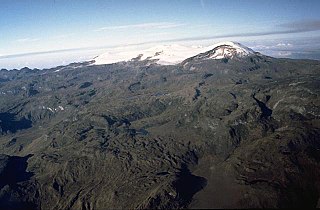
Nevado del Ruiz, also known as La Mesa de Herveo is a volcano on the border of the departments of Caldas and Tolima in Colombia, being the highest point of both. It is located about 130 km (81 mi) west of the capital city Bogotá. It is a stratovolcano composed of many layers of lava alternating with hardened volcanic ash and other pyroclastic rocks. Volcanic activity at Nevado del Ruiz began about two million years ago, during the Early Pleistocene or Late Pliocene, with three major eruptive periods. The current volcanic cone formed during the present eruptive period, which began 150,000 years ago.

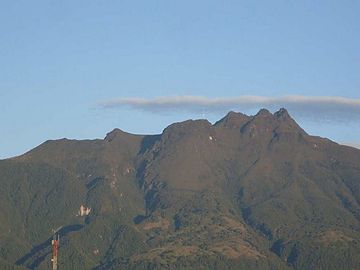
Galeras is an Andean stratovolcano in the Colombian department of Nariño, near the departmental capital Pasto. Its summit rises 4,276 metres (14,029 ft) above sea level. It has erupted frequently since the Spanish conquest, with its first historical eruption being recorded on December 7, 1580. A 1993 eruption killed nine people, including six scientists who had descended into the volcano's crater to sample gases and take gravity measurements in an attempt to be able to predict future eruptions. It is currently the most active volcano in Colombia.

Cerro Azul, sometimes referred to as Quizapu, is an active stratovolcano in the Maule Region of central Chile, immediately south of Descabezado Grande. Part of the South Volcanic Zone of the Andes, its summit is 3,788 meters (12,428 ft) above sea level, and is capped by a summit crater that is 500 meters (1,600 ft) wide and opens to the north. Beneath the summit, the volcano features numerous scoria cones and flank vents.
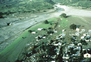
The Armero tragedy occurred following the eruption of the Nevado del Ruiz stratovolcano in Tolima, Colombia, on November 13, 1985. The volcano's eruption after 69 years of dormancy caught nearby towns unprepared, even though volcanological organizations had warned the government to evacuate the area after they detected volcanic activity two months earlier.

The Nevado del Quindío, also known as Volcán Paramillo del Quindío or simply Paramillo del Quindío, is an inactive volcano located in the Central Cordillera of the Andes in central Colombia. The summit marks the tripoint of the departments of Risaralda, Tolima, and Quindío, and is the highest point of the latter. The mountain is the fourth highest peak in Los Nevados National Natural Park among those with a topographic prominence exceeding 300 meters. There are no historical records of any eruption. The andesitic volcano is located on top of the Palestina Fault.

The Nevado del Tolima is a Late Pleistocene to recently active andesitic stratovolcano located in the Tolima department, Colombia. The volcano lies south of Nevado del Ruiz volcano and is situated within the Los Nevados National Natural Park. The volcano, whose most recent activity dates to 1943 and last major eruption around 3600 years ago, overlies the Eocene El Bosque Batholith, dated at 49.1 ± 1.7 Ma.
Nevado de Santa Isabel is a shield volcano straddling the boundaries of the Colombian departments of Tolima, Caldas, and Risaralda, being the highest point of the latter. The volcano lies approximately 10 kilometers southwest of the larger Nevado del Ruiz volcano. Santa Isabel is the third highest peak in Los Nevados National Natural Park. It is a relatively flat volcano with three domes of nearly equal elevation.

Nevado del Huila at 5,364 metres (17,598 ft), is the highest volcano in Colombia, located at the tripoint of the departments of Huila, Tolima and Cauca. It is visible from the city of Cali. The andesitic volcano is located on top of the Ibagué Batholith.

Puracé is an andesitic stratovolcano located in the Puracé National Natural Park in the Cauca Department, Colombia. It is part of the North Volcanic Zone of the Andean Volcanic Belt. The volcano is located at the intersection of the Coconucos and Morras Faults.
Cerro Negro de Mayasquer is a volcano on the border of Colombia and Ecuador. It lies 3 kilometres (2 mi) north-west of the volcano Chiles, and the two peaks are considered part of the same Chiles-Cerro Negro volcanic complex. These volcanoes, together with Cumbal are andesitic in rock type. A 1936 eruption reported by the Colombian government agency INGEOMINAS may have been from the Ecuadorean volcano Reventador, otherwise the volcano has not erupted for around 160,000 years.

Doña Juana is a stratovolcano, located within the Doña Juana-Cascabel Volcanic Complex National Natural Park in Nariño, Colombia.
The Nevado El Cisne or Nevado del Cisne, also known as Paramillo el Cisne or Paramillo del Cisne, is a volcano in the Central Ranges of the Andes in Colombia. Its summit is at an altitude of approximately 4,700 metres (15,400 ft).

The Arcabuco Formation is a geological formation of the Altiplano Cundiboyacense, Eastern Ranges of the Colombian Andes. The formation consists of thick beds of light-coloured quartzitic sandstones and conglomerates with occasional shales and dates to the Late Jurassic and Early Cretaceous periods; Tithonian to Berriasian epochs. Dinosaur footprints have been found in the Arcabuco Formation near the Iguaque anticlinal outside Chíquiza, Boyacá.
The Honda Group is a geological group of the Upper and Middle Magdalena Basins and the adjacent Central and Eastern Ranges of the Colombian Andes. The group, in older literature also defined as formation, is in its present-day type section in the Tatacoa Desert in the department of Huila subdivided into two main formations; La Victoria and Villavieja.
The Guavio Formation is a geological formation of the Altiplano Cundiboyacense, Eastern Ranges of the Colombian Andes. The formation consists of conglomerates, shales and limestones, dates to the Late Jurassic and Early Cretaceous periods; Tithonian to Berriasian epochs and has a maximum thickness of 1,000 metres (3,300 ft).
The Romeral fault system is a megaregional system of major parallel and anastomosing faults in the Central Ranges of the Colombian Andes and the Cauca, Amagá, and Sinú-San Jacinto Basins. The system spans across ten departments of Colombia, from northeast to south Bolívar, Sucre, Córdoba, Antioquia, Caldas, Risaralda, Quindío, Valle del Cauca, Cauca and Nariño. The fault zone extends into Ecuador where it is known as the Peltetec fault system. The in detail described part of the Romeral fault system south of Córdoba has a total length of 697.4 kilometres (433.3 mi) with a cumulative length of 1,787.9 kilometres (1,110.9 mi) and runs along an average north to south strike of 017.6 ± 16, cross-cutting the central-western portion of Colombia.
The Palestina Fault is a regional sinistral oblique thrust fault in the departments of Antioquia, Caldas and Bolívar in central Colombia. The fault has a total length of 369.6 kilometres (229.7 mi) and runs along an average north-northeast to south-southwest strike of 017.8 ± 11 along the Central Ranges of the Colombian Andes.

The Colombian Geological Survey (CGS) is a scientific agency of the Colombian government in charge of contributing to the socioeconomic development of the nation through research in basic and applied geosciences of the subsoil, the potential of its resources, evaluating and monitoring threats of geological origin, managing the geoscientific knowledge of the nation, and studying the nuclear and radioactive elements in Colombia.

The Paipa–Iza volcanic complex is a volcanic field of Late Pliocene to Early Pleistocene age on the Altiplano Cundiboyacense in the Eastern Ranges of the Colombian Andes. It is the northernmost volcanic complex of the Andean Volcanic Belt with Fueguino in Tierra del Fuego, Chile, at the opposite end of the Andean mountain belt.

The Tahamí or Tahamí–Panzenú terrane is one of the geological provinces (terranes) of Colombia. The terrane, dating to the Permo-Triassic, is situated on the North Andes plate. The contact with the Chibcha, Arquía and Quebradagrande terranes is formed by the megaregional Romeral fault system. A tiny terrane is located at the contact with the Quebradagrande terrane; Anacona terrane.