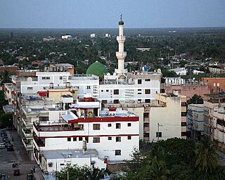
Riohacha is a city in the Riohacha Municipality in the northern Caribbean Region of Colombia by the mouth of the Ranchería River and the Caribbean Sea. It is the capital city of the La Guajira Department. It has a sandy beach waterfront.

The Guajira Peninsula is a peninsula in northern Colombia and northwestern Venezuela in the Caribbean. It is the northernmost peninsula in South America and has an area of 25,000 km2 (9,700 sq mi) extending from the Manaure Bay (Colombia) to the Calabozo Ensenada in the Gulf of Venezuela (Venezuela), and from the Caribbean to the Serranía del Perijá mountains range.
Maicao is a city and municipality in the Department of La Guajira, northern Republic of Colombia. It is located 76 km from Riohacha, the capital of the department and is the second largest urban center near the border with Venezuela, after the city of Cúcuta.

The Caribbean region of Colombia or Caribbean coast region is in the north of Colombia and is mainly composed of 8 departments located contiguous to the Caribbean. It's the second most populated region in the country after Andean Region with approximately 11 million residents according to the Colombian Census 2018. The area covers a total land area of 110,000 km2 (42,000 sq mi), including the Archipelago of San Andrés, Providencia and Santa Catalina in the Caribbean Sea.

The Wayuu are an Indigenous ethnic group of the Guajira Peninsula in northernmost Colombia and northwest Venezuela. The Wayuu language is part of the Arawakan language family.

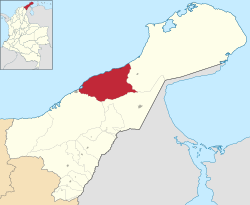
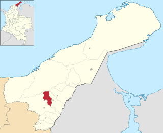
La Guajira is a department of Colombia. It occupies most of the Guajira Peninsula in the northeast region of the country, on the Caribbean Sea and bordering Venezuela, at the northernmost tip of South America. The capital city of the department is Riohacha.

Punta Gallinas is a headland in northern Colombia. Located in Uribia Municipality, La Guajira Department, it is the northernmost point on the mainland of South America, and one of the extreme points of South America.

The flag of La Guajira was officially adopted by the Departmental Assembly by means of Ordinance 028 of September 29, 1966. Previously, the flag had already been in use as the flag of the Intendancy of La Guajira, and subsequently it was modified last by Ordinance 052 of 1994.

The Ranchería River is a river located in northern La Guajira Department, Colombia. Born in the Sierra Nevada de Santa Marta southern steps flows south, abruptly turns northeast and then north where it finally flows into the Caribbean Sea. It is the main river of La Guajira Department and has great significance for the Wayuu people.

Barrancas is a town and municipality of the Colombian Department of La Guajira. The municipality of Barrancas is located to the left margin of the Ranchería River in a valley formed between the Sierra Nevada de Santa Marta mountains and the Serranía del Perijá. Barrancas has a total area of 742 km2 and at 40 meters over sea level. The average temperature is 28 °C throughout the year and distances from the capital of the Department of La Guajira, Riohacha. It became a municipality in 1892.

Fonseca is a municipality located in the Colombian Department of La Guajira. The town celebrates the Festival del Retorno in honor of St Augustine with religious celebrations, vallenato music events and others.

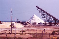
Uribia is a town and municipality of the La Guajira department of Colombia. It is the youngest municipality of this Department since the year 2000. Northern Zone of the Cerrejón coal mines are located in this municipality. The municipality also contains the Serranía de Macuira mountain range which is an isolated low altitude mountain range in the middle of La Guajira Desert. One third of this mountain range is also a National Natural Park of Colombia.

Albania is a town and municipality of the Colombian Department of La Guajira. Is the youngest municipality of this Department along with the town of Uribia and others, created on March 19, 2000. Albania neighbours and exclusive enclosed camp site for the Cerrejón coal mine workers and their families, named Mushaisa.

Dibulla is a town and municipality located in the Department of La Guajira, Colombia by the Caribbean Sea and the Sierra Nevada de Santa Marta mountains on the Guajira Peninsula. It was proclaimed municipality in 1995.
Distracción is a town and municipality in the Colombian Department of La Guajira. Founded in 1845 by a man from neighboring Barrancas named Antonio María Vidal on the right margin of the Ranchería River.

The University of La Guajira, also known as Uniguajira, is a public, departmental university based primarily in the city of Riohacha, La Guajira, Colombia. The university was established by ordinance No. 011 and 012 of 1976, by the Departmental Assembly, and opened in February 1977. Its main campus, known as the University Citadel, is located in the outskirts of the city, and it hosts the faculties of Basic Sciences, Economic and Administrative Sciences, Education Sciences, Engineering, and Social and Humanity Sciences. The university also has several satellite campuses across the department in the cities of Albania, Fonseca, Maicao, Manaure, and Villanueva, and one campus in the department of Córdoba in the city of Montería. The university offers education at technical, undergraduate and postgraduate levels. The mascot is a jellyfish, symbolizing power and simplicity.

Bahía Portete – Kaurrele National Natural Park is a national natural park in Uribia, La Guajira, Colombia. The northernmost national park of mainland South America is located at the Caribbean coast of the La Guajira peninsula in Bahía Portete, between Cabo de la Vela and Punta Gallinas. Established on December 20, 2014, it is the most recently designated national park of the country. As of 2017, 59 nationally defined protected areas are incorporated in Colombia. The park hosts a high number of marine and terrestrial species.

Cabo de la Vela is a headland in the Guajira Peninsula in Colombia with an adjacent small fishing village. It is a popular ecotourism destination of the Caribbean region of Colombia.
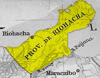
Riohacha Province was a province of Gran Colombia. With the 1824 changes in the subdivisions of Gran Colombia, it became part of Magdalena Department. Riohacha[a], is a city in the Riohacha Municipality in the northern Caribbean Region of Colombia by the mouth of the Ranchería River and the Caribbean Sea. Riohacha is the capital city of La Guajira Department.
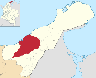
Riohacha Municipality is located on the Caribbean region of Colombia of La Guajira Department, Colombia. It extends over 3,120 km2 and has an urban part divided into 10 Communes, 14 Corregimientos and 8 Resguardos Indígenas. 7 of the indigenous regions belong to the Wayuu and one in the Sierra Nevada de Santa Marta region shared by the Kogi, the Wiwa, and the Ijka, a subtribe of the Arhuaco people.