
Huehuetenango is a city and municipality in the highlands of western Guatemala. It is also the capital of the department of Huehuetenango. The city is situated 269 kilometres (167 mi) from Guatemala City, and is the last departmental capital on the Pan-American Highway before the Mexican border at La Mesilla. Its primary export is coffee.

Salina Cruz is a major seaport on the Pacific coast of the Mexican state of Oaxaca. It is the state's fourth-largest city and is the municipal seat of the municipality of the same name. It is part of the Tehuantepec District in the west of the Istmo Region. The city had a 2020 census population of 76,660, while its municipality, with an area of 131.9 km2 (50.9 sq mi) had a population of 84,438, the state's fifth-largest municipality in population.

Murillo is a town and municipality in the Tolima department of Colombia. The population of the municipality was 4,953 as of the 2005 census, 1,569 who lived within the town of Murillo, the remainder in rural areas of the municipality.

Belmira is a town and municipality in the northern subregion of the Colombian department of Antioquia. It is approximately 62 km from the city of Medellin. It lies at an altitude of 2,550 m above sea level.
Gómez Plata is a town and municipality in the Colombian department of Antioquia. It is part of the subregion of Northern Antioquia. The population was 8,235 at the 2018 census.

Sopetrán is a municipality of Colombia, located in the subregion west of the state of Antioquia. It is bounded to the north by the municipality of Olaya, to the east by the municipality of Belmira, to the south by the municipalities of San Jerónimo and Ebéjico, and to the west by the municipality of Santa Fe de Antioquia. The population was 13,748 at the 2018 census. It is 59 kilometers from the city of Medellin, the state capital of Antioquia. The municipality of Sopetrán has an area of 223 square kilometers.

Yarumal is a municipality in the Antioquia Department, Colombia. The municipality has an area of 738.3 km2 (285.1 sq mi). The population was 41,542 at the 2018 census. Its average elevation is 2,265 m (7,431 ft) above sea level.

Yarmouth, officially named the Municipality of the District of Yarmouth, is a district municipality in Yarmouth County, Nova Scotia, Canada. Statistics Canada classifies the district municipality as a municipal district.

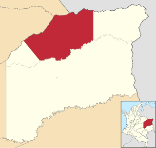
Toledo is a Colombian municipality and town located in the department of North Santander. It is on the border with Boyacá Department and has natural gas development in the township of Gibraltar. In August 2011 the Gibraltar to Bucaramanga gas pipeline was completed.

Acandí is a town in Colombia at the northern extremity of the department of Chocó in the northwest of Colombia, bordering Panama and the Caribbean Sea. It is 366 km (227 mi) from the department's capital, Quibdó. Its average temperature is 28 degrees Celsius (82 °F). It was founded around 1887, and it became a municipality in 1905, previously being part of Turbo. The name "Acandí" is a corruption of the indigenous word "Acanti", which means "River of Stone".

Lloró is a municipality and town in the Chocó Department, Colombia. It claims the second world record for highest average annual precipitation with 12,717 mm (501 in), after López de Micay, which holds an also disputed record with 12,892.4 mm (508 in). The official record is held by Mawsynram, India. The rainfall data was measured in its Agricultural Farm, managed by the University of Bogotá, between 1952 and 1989. If accurate, that would make it the wettest place in the world. The town is named for Gioró, a pre-Columbian indigenous chief.

Villamaría is a town and municipality in the Colombian Department of Caldas. Located in the Colombian coffee growing axis, it was made part of the "Coffee Cultural Landscape" UNESCO World Heritage Site in 2011.

Puerto Guzmán is a town and municipality located in the Putumayo Department, Republic of Colombia.

Guamal is a town and municipality in the Meta Department, Colombia.
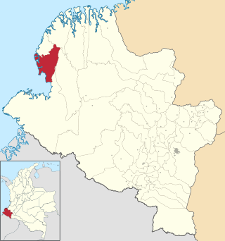
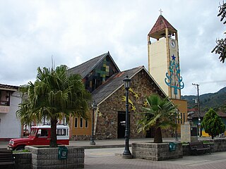
Francisco Pizarro is a town and municipality in the Nariño Department, Colombia named after the Spanish explorer Francisco Pizarro.

Gualmatán, is a town and municipality in the Nariño Department, Colombia.
La Primavera is a town and municipality located in the Department of Vichada, Colombia.
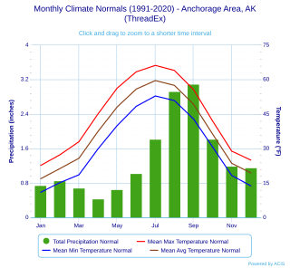
Anchorage, Alaska has a subarctic climate with the code Dsc according to the Köppen climate classification due to its short, cool summers. The weather on any given day is very unpredictable. Some winters feature several feet of snow and cold temperatures, while the summers are typically mild but are cool compared to the contiguous US and interior Alaska. Because of Anchorage's high latitude, summer days are very long and winter daylight hours are very short. The longest day of sunlight being 18hrs and 21 minutes, and shortest being 5 hours and 28 minutes. Anchorage is often cloudy during the winter, which decreases the amount of sunlight experienced by residents.

The Roman Catholic Diocese of Istmina–Tadó is a diocese located in the cities of Istmina and Tadó in the ecclesiastical province of Santa Fe de Antioquia in Colombia.
Pie de Pepe is a village in Medio Baudó Municipality, Chocó Department in Colombia.


