The Republic of Colombia is situated largely in the north-west of South America, with some territories falling within the boundaries of Central America. It is bordered to the north-west by Panama; to the east by Brazil and Venezuela; to the south by Ecuador and Peru; and it shares maritime limits with Costa Rica, Nicaragua, Honduras, Jamaica, the Dominican Republic, and Haiti.

Antioquia is one of the 32 departments of Colombia, located in the central northwestern part of Colombia with a narrow section that borders the Caribbean Sea. Most of its territory is mountainous with some valleys, much of which is part of the Andes mountain range. Antioquia has been part of many territorial divisions of former countries created within the present-day territory of Colombia. Prior to adoption of the Colombian Constitution of 1886, Antioquia State had its own sovereign government.
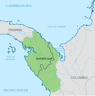
The Darién Gap is a geographic region that connects the American continents, stretching across southern Panama's Darién Province and the northern portion of Colombia's Chocó Department. Consisting of a large watershed, dense rainforest, and mountains, it is known for its remoteness, difficult terrain, and extreme environment, with a reputation as one of the most inhospitable regions in the world. Nevertheless, as the only land bridge between North and South America, the Darién Gap has historically served as a major route for both humans and wildlife.

Darién is a province in Panama whose capital city is La Palma. With an area of 11,896.5 km2 (4,593.3 sq mi), it is located at the eastern end of the country and bordered to the north by the province of Panamá and the region of Kuna Yala. To the south, it is bordered by the Pacific Ocean and Colombia. To the east, it borders Colombia; to the west, it borders the Pacific Ocean and the province of Panama.

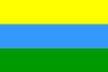
Chocó Department is a department of the Pacific region of Colombia known for hosting the largest Afro-Colombian population in the nation, and a large population of Amerindian and mixed African-Amerindian Colombians. It is in the west of the country, and is the only Colombian department to have coastlines on both the Pacific Ocean and the Atlantic Ocean. It contains all of Colombia's border with Panama. Its capital is Quibdó.

Quibdó is the capital city of Chocó Department, in the Pacific Region of Colombia, and is located on the Atrato River. The municipality of Quibdó has an area of 3,507 km² and a population of 129,237, predominantly Afro Colombian, including Zambo Colombians.

The Atrato River is a river of northwestern Colombia. It rises in the slopes of the Western Cordillera and flows almost due north to the Gulf of Urabá, where it forms a large, swampy delta. Its course crosses the Chocó Department, forming that department's border with neighboring Antioquia in two places. Its total length is about 650 km (400 mi), and it is navigable as far as Quibdó, the capital of the department.

The Gulf of Urabá is a gulf on the northern coast of Colombia. It is part of the Caribbean Sea. It is a long, wide inlet located on the coast of Colombia, close to the connection of the continent to the Isthmus of Panama. The town of Turbo, Colombia, lies at the mid eastern side naturally sheltered by the Turbo Bay part of the Gulf. The Atrato River flows into the Gulf of Urabá.

Vigía del Fuerte is a town and municipality in the Colombian department of Antioquia. It is part of the Urabá Antioquia sub-region.

Necoclí is a town and municipality in Antioquia Department, Colombia. Located on the eastern shore of the Gulf of Urabá, it is part of the Urabá Antioquia sub-region. The population is predominantly Afro-Colombian.

Turbo is a port city in Antioquia Department, Colombia. Part of the Urabá Antioquia sub-region, it is located on the coast of Gulf of Urabá, 340 km north of Medellín. This port city is the capital of the Urabá region of Antioquia. The place where Turbo is today was known as Pisisí, but by 1741 people were already talking about Turbo. By a decree on May 11, 1839, the central government spent one thousand pesos for military service barracks in Turbo. In 1840, the republican president assigned one thousand fanegas of uncultivated lands for the new population. It was established as a municipality in 1847.

The Pacific/Chocó region is one of the five major natural regions of Colombia. Ecologically, this region belongs entirely to the Chocó Biogeographic Region and is considered a biodiversity hotspot. It also has areas with the highest rainfall in the world, with areas near Quibdo, Chocó reaching up to 13,000 mm (510 in) annually.
Riosucio is a municipality and town in the Department of Chocó, Colombia. The municipality and town are located in the Atrato River basin, on the Chocoan side of Urabá, a region spanning the departments Chocó and Antioquia.

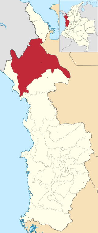
Urabá Antioquia is a subregion in the Colombian Department of Antioquia that consists of two enclaves, one forming the northwest corner of the department the other, the west, both are along the Atrato River and are separated by the El Carmen del Darién and Riosucio municipalities of the Chocó Department with territories in both municipalities in dispute with Chocó. The region is made up by 11 municipalities. Most of this region's northern portion is part of the Colombian Caribbean Region bordering the Caribbean Sea.

Because of its natural structure, Colombia can be divided into six distinct natural regions. These consist of the Andean Region, covering the three branches of the Andes mountains found in Colombia; the Caribbean Region, covering the area adjacent to the Caribbean Sea; the Pacific Region adjacent to the Pacific Ocean; the Orinoquía Region, part of the Llanos plains mainly in the Orinoco river basin along the border with Venezuela; the Amazon Region, part of the Amazon rainforest; and finally the Insular Region, comprising the islands in both the Atlantic and Pacific Oceans. Colombia is located in South America.
Capurganá is a town of the municipality of Acandí on the northwestern coast of the Gulf of Urabá in the Colombian department of Chocó, adjacent to the border between Colombia and Panama. Previously a base site for eco-tourists, since 2010 the town's main source of income has been migrants preparing to hike into Panama, across the Darién Gap. In 2019 it was described as a "smugglers' town".

Sapzurro is a small town on the Caribbean Sea located in the northwest corner of the Republic of Colombia. It is part of the Municipality of Acandí, in the Chocó Department of the Darién region. The closest city is Capurganá, a semi-popular port town, and it is across the international boundary from the Panamanian town of La Miel.

The Colombia–Panama border is the 339-kilometer-long (211 mi) international boundary between Colombia and Panama. It also splits the Darién Gap, a break across the South American and North American continents. This large watershed, forest, and mountainous area is in the north-western portion of Colombia's Chocó Department and south-eastern portion of Panama's Darién Province.

The Chocó–Darién moist forests (NT0115) is a largely forested, tropical ecoregion of northwestern South America and southern Central America. The ecoregion extends from the eastern Panamanian province of Darién and the indigenous region of Guna Yala to almost the entirety of Colombia's Pacific coast, including the departments of Cauca, Chocó, Nariño and Valle del Cauca.
The Unguía Fault is an oblique dextral thrust fault in the department of Chocó in northwestern Colombia and continuing offshore Panama in the Caribbean Sea. The fault has a total length of 139.9 kilometres (86.9 mi) and is arcuate, running along a strike of 356.3 ± 30.