Zipaquirá

Last updated • 7 min readFrom Wikipedia, The Free Encyclopedia
Zipaquirá
Municipality and city
Plaza principal de Zipaquira 2014-09-05.jpg
Central square of Zipaquirá
Flag of Zipaquira.svg
Colombia - Cundinamarca - Zipaquira.svg
Location of the town and municipality of Zipaquirá in Cundinamarca
Colombia location map.svg
Red pog.svg
Zipaquirá
Location in Colombia
Coordinates: 5°02′00″N74°00′00″W / 5.03333°N 74.00000°W / 5.03333; -74.00000
CountryFlag of Colombia.svg  Colombia
Departamento Cundinamarca
Province Central Savanna Province
Founded18 July 1600
Founded byLuis Henríquez
Government
  MayorFabián Rojas (2024-2027)
Area
   Municipality and city
194.8 km2 (75.2 sq mi)
  Urban
10.25 km2 (3.96 sq mi)
Elevation
2,650 m (8,690 ft)
Population
 (2018 census) [1]
   Municipality and city
130,537
  Density670/km2 (1,700/sq mi)
   Urban
106,461
  Urban density10,000/km2 (27,000/sq mi)
Demonym Zipaquireño/a
Time zone UTC-5
Area code +1
Website Official website
Censo DANE 2005
Main square of Zipaquira Zipa Plaza.jpg
Main square of Zipaquirá
Typical street of Zipaquira July 2008 Colombia ;- 1658.jpg
Typical street of Zipaquirá

Zipaquirá (Spanish pronunciation: [sipakiˈɾa] ) is a municipality and city of Colombia in the department of Cundinamarca. Its neighboring municipalities are Cogua and Nemocón to the north; Tocancipá to the east; Tabio, Cajicá and Sopó to the south; and Subachoque and Pacho to the west. Its seat of municipal government is 49 kilometers from the national capital Bogotá. It is part of the Greater Bogotá Metropolitan Area, and is the capital of the Sabana Centro province. It is also the headquarters of the diocese of the same name and that includes much of the Department of Cundinamarca, extending to the centre of Bogotá, the region of Rionegro, the Ubaté Valley, and the region of Guavio.

Contents

The city is primarily known for its Salt Cathedral, an underground church built inside a salt mine in a tunnel made as result of the excavation of the salinas. Zipaquirá has an original architecture, and the old city centre is a tourist attraction. Its main square is surrounded by old buildings in the Spanish Colonial style. This small city can be reached by train from Bogotá.

Etymology

In Chibcha, the language of the Muisca, who inhabited the Altiplano Cundiboyacense before the Spanish conquest, the name means "The Land of the zipa". Zipa was the ruler of this territory. Another origin is "City of our father". [2]

History

Pre-Spanish colonization

In the Abra Valley between Zipaquirá and Tocancipá were found some of the most ancient human remains of South America. The lithic strata reveal animal bones and carbon fragments, analysed with carbon 14 dating to be around 12,500 years old, which makes it the oldest evidence of human settlement on the Altiplano Cundiboyacense.

There are two possible origins of its name. One of them is taken from the indigenous people who inhabited the foot of the Zippa mountain range, "Chicaquicha", which means "our large wall" or according to other sources, "city of our father", and until the 19th century the name was written beginning with the letter C. The other possibility refers to the name "zipa", a title conferred to the governor of the village and to his wife, the latter known by the title of "Quira", and thus "Zipa-Quirá". The native people who lived there settled in the upper part of the mine called "Puebla Viejo", now known as Santiago Pérez, approximately 200 meters above the present site of the city, and where early Spanish descriptions (1537) speak of "seeing a few hundred dwellings with a population of 12,000 people".

These lands were part of the domain of the zipa of Bacatá, the leader of the southern part of the Muisca. This area of the Bogotá plain had at that time a series of small lakes and canyons which made possible the transportation of its inhabitants by canoe, by means of which the inhabitants of Nemocón, Gachancipá, and Tocancipá reached Chicaquicha in order to seek supplies of salt which they traded for pottery and tiles. Salt was also traded with peoples throughout the Andean region of Colombia, including the Panche, and Pantágora in the present department of Tolima, and the Muzo of the present-day department of Boyacá.

New Kingdom of Granada

On July 18, 1600, Don oidor Luis Henríquez established a settlement on the site with workers and their families, and named it the "Village of Zipaquirá".

On August 2, 1600, Henríquez contracted Juan de Robles to construct the Church of Zipaquirá, which was later reconstructed by Pedro de Tovar y Buendía, when the parish priest was Fernando de Buenaventura y Castillo.

In 1605 the area was named the Corregimiento de Zipaquirá and removed to its original location; this was done due to the limited area available on the originally occupied plain, as well as to the fact that the Spanish forces ordered that no Spanish, negros, mestizos or mulattos were permitted to live in native villages, even if they had purchased land therein.

In 1623, the Spanish official Don Francisco de Sosa named as wards the 321 native inhabitants in the "Old Town", according to the declaration of Alfredo Tinoco.

On October 5, 1638, Gabriel de Carvajal became the guardian of 771 natives in the region and 125 in Tibitó.

In 1778, by order of the Viceroy Manuel Antonio Flórez, the natives who lived in Zipaquirá were transported to Nemocón in order to prevent constant rebellions of previous owners of the salt deposits.

On August 3, 1779, Zipaquirá saw the creation of the Holy Trinity and San Antonio de Padua parish.

In 1852, Zipaquirá became a province, retaining the status until 1855.

During the Spanish reconquest, on August 3, 1816, the so-called Zipaquirá Martyrs were executed in the city square.

Republican era

With the Constitution of Cundinamarca of 1815, the city became the capital of the province of the same name. On July 10, 1863, it was designated the capital of the Sovereign State of Cundinamarca, although subsequently it was named Funza by decree of president Morales. Law number 46 of April 29, 1905, created the Department of Quesada, the capital of which was Zipaquirá, which remained so until 1910.

Geography and description

Zipaquirá is located 48 kilometres (30 mi) north of Bogotá, linked by road and by train. The most famous of its salt mines has been exploited since pre-Columbian times by the Muisca, in which is located the famous Salt Cathedral. González Forero Square is the center of the city, surrounded by buildings that have conserved their colonial style and are considered to be national monuments. The square contains a cathedral constructed between 1760 and 1870, with its stone façade, as well as the city hall and the Salinas administration building, with their green republican-style roofs.

The city has undergone recent changes, having transformed streets in the center to pedestrian walkways, limiting vehicle traffic in the area in an attempt at preservation and conservation, and lending a more cordial aspect for tourists. As part of this strategy, the city has also carried out a project of restructuring the Sabana Station (railroad), and, next to it, the construction of Parque La Esperanza.

Currently, the Bogotá - Chía - Cajicá - Zipaquirá highway is completed, making possible more rapid and safer access to the city, since the Cajicá - Zipaquirá segment was one of the most accident-prone roads in the country.

Zipaquirá offers the visitor typical restaurants, colonial houses that are almost 300 years old, tourist agencies, recreation centers such as Panaca Sabana, museums, crafts, and an interesting retail infrastructure.

Agriculture is also important in the municipality, especially dairy and potato farming. Industry in the region is closely associated with the production, processing, and refining of salt. The estimated population is 130,000 inhabitants (called "Zipaquireños").

The streets, the park, the houses, and the square commemorate the era of the colony. As well as the communal movement and the indigenous struggles that gave way to a new chapter in the history of the country. Today through tourist guides and locals the indigenous origins of the municipality, which in the indigenous language is called Chicaquicha, is visited by a large number of tourists from around the world.

Among the most famous events of the area are the majestic Holy Week processions, organized for the last 54 years by the Nazarene of Zipaquirá Congregation, with processions throughout the week with beautiful Spanish religious relics that attract both local residents and visitors. Tourists actively participate during Good Friday when the procession of the Path of the Cross journeys up to the Plazoleta del Minero to the entrance of the Salt Cathedral.

Climate

Climate data for Zipaquirá/Nemocón (Checua-Nemocon), elevation 2,580 m (8,460 ft), (1981–2010)
MonthJanFebMarAprMayJunJulAugSepOctNovDecYear
Mean daily maximum °C (°F)20.6
(69.1)
20.2
(68.4)
20.8
(69.4)
19.7
(67.5)
18.9
(66.0)
17.9
(64.2)
17.9
(64.2)
18.5
(65.3)
19.2
(66.6)
19.9
(67.8)
20.4
(68.7)
20.5
(68.9)
19.5
(67.1)
Daily mean °C (°F)13.8
(56.8)
14.0
(57.2)
14.4
(57.9)
14.4
(57.9)
14.2
(57.6)
13.6
(56.5)
13.6
(56.5)
13.6
(56.5)
13.9
(57.0)
14.1
(57.4)
14.6
(58.3)
14.1
(57.4)
14.0
(57.2)
Mean daily minimum °C (°F)7.1
(44.8)
8.1
(46.6)
8.7
(47.7)
10.1
(50.2)
10.5
(50.9)
9.8
(49.6)
10.0
(50.0)
9.5
(49.1)
9.1
(48.4)
9.5
(49.1)
9.8
(49.6)
8.0
(46.4)
9.1
(48.4)
Average precipitation mm (inches)23.7
(0.93)
53.0
(2.09)
69.8
(2.75)
78.9
(3.11)
67.3
(2.65)
34.6
(1.36)
37.0
(1.46)
37.5
(1.48)
59.1
(2.33)
74.8
(2.94)
61.0
(2.40)
31.5
(1.24)
628.1
(24.73)
Average precipitation days47912141215151112117125
Average relative humidity (%)73737479808180797779797678
Mean monthly sunshine hours 195.3144.0158.1123.0127.199.0139.5124.0141.0136.4135.0167.41,689.8
Mean daily sunshine hours 6.35.15.14.14.13.34.54.04.74.44.55.44.6
Source: Instituto de Hidrologia Meteorologia y Estudios Ambientales [3]

Born in Zipaquirá

Raised in Zipaquirá

Zipaquira panorama.jpg
Panorama of Zipaquirá

See also

Related Research Articles

<span class="mw-page-title-main">Cundinamarca Department</span> Department of Colombia

Department of Cundinamarca is one of the departments of Colombia. Its area covers 22,623 square kilometres (8,735 sq mi) and it has a population of 2,919,060 as of 2018. It was created on August 5, 1886, under the constitutional terms presented on the same year. Cundinamarca is located in the center of Colombia.

<span class="mw-page-title-main">Muisca</span> Indigenous people of Colombia

The Muisca are an Indigenous people and culture of the Altiplano Cundiboyacense, Colombia, that formed the Muisca Confederation before the Spanish conquest. The people speak Muysccubun, a language of the Chibchan language family, also called Muysca and Mosca. The first known contact with the West was dispatched by the Spanish Empire in 1537 at the time of the conquest.

<span class="mw-page-title-main">Altiplano Cundiboyacense</span> Plateau in the Colombian Andes

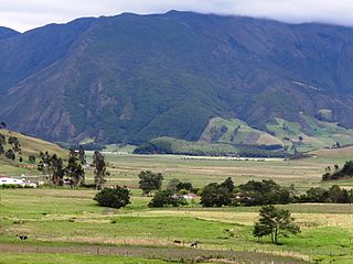
The Altiplano Cundiboyacense is a high plateau located in the Eastern Cordillera of the Colombian Andes covering parts of the departments of Cundinamarca and Boyacá. The altiplano corresponds to the ancient territory of the Muisca. The Altiplano Cundiboyacense comprises three distinctive flat regions; the Bogotá savanna, the valleys of Ubaté and Chiquinquirá, and the valleys of Duitama and Sogamoso. The average altitude of the altiplano is about 2,600 metres (8,500 ft) above sea level but ranges from roughly 2,500 metres (8,200 ft) to 4,000 metres (13,000 ft).

<span class="mw-page-title-main">History of Bogotá</span>

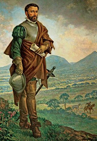
The history of Bogotá refers to the history of the area surrounding the Colombian capital Bogotá. The area around Bogotá was first populated by groups of indigenous people that migrated from mesoamerica. Among these groups were the Muisca that settled on the Altiplano Cundiboyacense in what is now Cundinamarca and Boyacá. With the arrival of the Spanish colonizers the area was developed into a major settlement that was founded by Gonzalo Jiménez de Quesada in 1538, and became capital of the Spanish Empire provinces and the seat of the Viceroyalty of New Granada. With independence, Bogotá became the capital of the Gran Colombia, and -subsequently- of the Republic of Colombia.

<span class="mw-page-title-main">Cogua</span> Place in Cundinamarca, Colombia

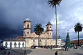
Cogua is a municipality and town of Colombia in the department of Cundinamarca. It is situated on northern part of the Bogotá savanna with the urban centre at an altitude of 2,600 metres (8,500 ft) at 50 kilometres (31 mi) from the capital Bogotá. Cogua borders Tausa in the north, Nemocón in the east, Pacho in the west and Zipaquirá in the south.

<span class="mw-page-title-main">Gachancipá</span> Municipality and town in Cundinamarca, Colombia

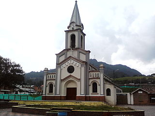
Gachancipá is a municipality and town of Colombia in the Central Savanna Province, part of the department of Cundinamarca. The urban centre is located on the Altiplano Cundiboyacense at 42 kilometres (26 mi) from the capital Bogotá. The municipality borders Guatavita and Tocancipá in the south, Sesquilé and Guatavita in the east, Nemocón in the west and Suesca in the north.

<span class="mw-page-title-main">Nemocón</span> Place in Cundinamarca, Colombia

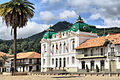
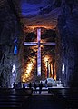
Nemocón is a municipality and town of Colombia in the Central Savanna Province, part of the department of Cundinamarca. Nemocón, famous for its salt mine, was an important village in the Muisca Confederation, the country in the central Colombian Andes before the arrival of the Spanish. The municipality is situated in the northern part of the Bogotá savanna, part of the Altiplano Cundiboyacense with its urban centre at an altitude of 2,585 metres (8,481 ft) and 65 kilometres (40 mi) from the capital Bogotá. Nemocón is the northeasternmost municipality of the Metropolitan Area of Bogotá and the Bogotá River originates close to Nemocón. The median temperature of Nemocón is 12.8 °C. The municipality borders Tausa in the north, Suesca and Gachancipá in the east, Tocancipá and Zipaquirá in the south and in the west the rivers Checua and Neusa and the municipality of Cogua.

<span class="mw-page-title-main">Tausa</span> Municipality and town in Cundinamarca, Colombia

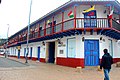
Tausa is a municipality and town of Colombia in the Ubaté Province, part of the department of Cundinamarca. Tausa is and was an important town on the Altiplano Cundiboyacense due to its salt mine. It was the third most prolific salt deposit for the original inhabitants of the area; the Muisca. Tausa's urban centre is located at an elevation of 2,950 metres (9,680 ft) and a distance of 65 kilometres (40 mi) from the capital Bogotá. The municipality borders San Cayetano, Carmen de Carupa and Sutatausa in the north, Pacho in the west, Sutatausa, Cucunubá and Suesca in the east and in the south with Nemocón and Cogua.

<span class="mw-page-title-main">Tocancipá</span> Municipality and town in Cundinamarca, Colombia

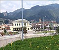
Tocancipá is a municipality and town of Colombia in the Central Savanna Province, part of the department of Cundinamarca. Tocancipá is situated in the northern part of the Bogotá savanna, part of the Altiplano Cundiboyacense in the Eastern Ranges of the Colombian Andes with the urban centre at an altitude of 2,605 metres (8,547 ft). The capital Bogotá, which metropolitan area includes Tocancipá, is 42 kilometres (26 mi) to the south. Tocancipá borders Gachancipá and Nemocón in the north, Zipaquirá in the west, Guasca and Guatavita in the east and Guasca and Sopó in the south.

<span class="mw-page-title-main">Zipacón</span> Municipality and town in Cundinamarca, Colombia

Zipacón is a municipality and town of Colombia in the Western Savanna Province, part of the department of Cundinamarca. The urban centre of Zipacón is situated at an altitude of 2,550 metres (8,370 ft) on the Bogotá savanna, the southern flatlands of the Altiplano Cundiboyacense in the Eastern Ranges of the Colombian Andes. Zipacón borders Anolaima, Facatativá, La Mesa and Bojacá.

<span class="mw-page-title-main">Bogotá savanna</span> Motane savanna in Altiplano Cundiboyacense

The Bogotá savanna is a montane savanna, located in the southwestern part of the Altiplano Cundiboyacense in the center of Colombia. The Bogotá savanna has an extent of 4,251.6 square kilometres (1,641.6 sq mi) and an average altitude of 2,650 metres (8,690 ft). The savanna is situated in the Eastern Ranges of the Colombian Andes.

<span class="mw-page-title-main">Piedras del Tunjo Archaeological Park</span> Archaeological park

Piedras del Tunjo is an important archaeological park established on a natural rock shelter 40 kilometres (25 mi) west of Bogotá in the municipality of Facatativá.

<span class="mw-page-title-main">Bacatá</span> Area on the Bogotá Savannah

Bacatá is the name given to the main settlement of the Muisca Confederation on the Bogotá savanna. It mostly refers to an area, rather than an individual village, although the name is also found in texts referring to the modern settlement of Funza, in the centre of the savanna. Bacatá was the main seat of the zipa, the ruler of the Bogotá savanna and adjacent areas. The name of the Colombian capital, Bogotá, is derived from Bacatá, but founded as Santafe de Bogotá in the western foothills of the Eastern Hills in a different location than the original settlement Bacatá, west of the Bogotá River, eventually named after Bacatá as well.

<span class="mw-page-title-main">Muisca Confederation</span> Former Andean highlands confederation

The Muisca Confederation was a loose confederation of different Muisca rulers in the central Andean highlands of what is today Colombia before the Spanish conquest of northern South America. The area, presently called Altiplano Cundiboyacense, comprised the current departments of Boyacá, Cundinamarca and minor parts of Santander.

<span class="mw-page-title-main">Ana María Groot</span> Colombian historian, archaeologist, anthropologist (born 1952)

Ana María Groot de Mahecha is a Colombian historian, archaeologist, anthropologist and associate professor at the Department of Anthropology of the Universidad Nacional de Colombia. Ana Mariá Groot speaks Spanish, English and French.

<span class="mw-page-title-main">Muisca economy</span> Aspect of indigenous Colombian culture

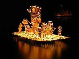
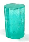
This article describes the economy of the Muisca. The Muisca were the original inhabitants of the Altiplano Cundiboyacense, the high plateau in the Eastern Ranges of central present-day Colombia. Their rich economy and advanced merchant abilities were widely known by the indigenous groups of the area and described by the Spanish conquistadores whose primary objective was the acquisition of the mineral resources of Tierra Firme; gold, emeralds, carbon, silver and copper.

<span class="mw-page-title-main">Spanish conquest of the Muisca</span> Part of the Spanish conquest of Colombia

The Spanish conquest of the Muisca took place from 1537 to 1540. The Muisca were the inhabitants of the central Andean highlands of Colombia before the arrival of the Spanish conquistadors. They were organised in a loose confederation of different rulers; the psihipqua of Muyquytá, with his headquarters in Funza, the hoa of Hunza, the iraca of the sacred City of the Sun Sugamuxi, the Tundama of Tundama, and several other independent caciques. The most important rulers at the time of the conquest were psihipqua Tisquesusa, hoa Eucaneme, iraca Sugamuxi and Tundama in the northernmost portion of their territories. The Muisca were organised in small communities of circular enclosures, with a central square where the bohío of the cacique was located. They were called "Salt People" because of their extraction of salt in various locations throughout their territories, mainly in Zipaquirá, Nemocón, and Tausa. For the main part self-sufficient in their well-organised economy, the Muisca traded with the European conquistadors valuable products as gold, tumbaga, and emeralds with their neighbouring indigenous groups. In the Tenza Valley, to the east of the Altiplano Cundiboyacense where the majority of the Muisca lived, they extracted emeralds in Chivor and Somondoco. The economy of the Muisca was rooted in their agriculture with main products maize, yuca, potatoes, and various other cultivations elaborated on elevated fields. Agriculture had started around 3000 BCE on the Altiplano, following the preceramic Herrera Period and a long epoch of hunter-gatherers since the late Pleistocene. The earliest archaeological evidence of inhabitation in Colombia, and one of the oldest in South America, has been found in El Abra, dating to around 12,500 years BP.

<span class="mw-page-title-main">Muisca warfare</span>

This article describes the warfare of the Muisca. The Muisca inhabited the Tenza and Ubaque valleys and the Altiplano Cundiboyacense, the high plateau of the Colombian Eastern Ranges of the Andes in the time before the Spanish conquest. Their society was mainly egalitarian with little difference between the elite class (caciques) and the general people. The Muisca economy was based on agriculture and trading raw materials like cotton, coca, feathers, sea snails and gold with their neighbours. Called "Salt People", they extracted salt from brines in Zipaquirá, Nemocón and Tausa to use for their cuisine and as trading material.

The Cabildo Mayor del Pueblo Muisca is an organisation of indigenous people, in particular the Muisca. It was established in September 2002 in Bosa, Bogotá, Colombia. The organisation, member of National Indigenous Organization of Colombia (ONIC), focuses on defending the rights of the descendants of the Muisca, and the development of cultural and historical heritage, territory and health and the linguistics of the indigenous language, Muysccubun.

References

  1. Citypopulation.de
  2. Espejo Olaya, 1999, p.1126
  3. "Promedios Climatológicos 1981–2010" (in Spanish). Instituto de Hidrologia Meteorologia y Estudios Ambientales. Archived from the original on 15 August 2016. Retrieved 17 June 2024.
  4. Parkin Daniels, Joe (28 July 2019). "Egan Bernal wins Tour de France and all of Colombia celebrates". The Guardian. Retrieved 28 July 2019.

Bibliography