The Republic of Colombia is situated largely in the north-west of South America, with some territories falling within the boundaries of Central America. It is bordered to the north-west by Panama; to the east by Brazil and Venezuela; to the south by Ecuador and Peru; and it shares maritime limits with Costa Rica, Nicaragua, Honduras, Jamaica, the Dominican Republic, and Haiti.

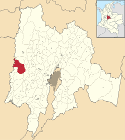
Department of Cundinamarca is one of the departments of Colombia. Its area covers 22,623 square kilometres (8,735 sq mi) and it has a population of 2,919,060 as of 2018. It was created on August 5, 1886, under the constitutional terms presented on the same year. Cundinamarca is located in the center of Colombia.

Nevado del Ruiz, also known as La Mesa de Herveo is a volcano on the border of the departments of Caldas and Tolima in Colombia, about 129 km (80 mi) west of the capital city Bogotá. It is a stratovolcano composed of many layers of lava alternating with hardened volcanic ash and other pyroclastic rocks. Volcanic activity at Nevado del Ruiz began about two million years ago, during the Early Pleistocene or Late Pliocene, with three major eruptive periods. The current volcanic cone formed during the present eruptive period, which began 150,000 years ago.

Risaralda is a department of Colombia. It is located in the western central of the country, in the Andean region, It is part of the Coffee axis with Caldas and Quindío. Its capital is Pereira. Risaralda is very well known for the high quality of its coffee, and a booming industry: automotive, clothes, food, trading of goods and services.

Manizales is a city in central Colombia. It is the capital of the Department of Caldas, and lies near the Nevado del Ruiz volcano.

Armenia is the capital of Quindío Department in the South American country of Colombia. Armenia is a medium-sized city and part of the "coffee axis" along with Pereira and Manizales. It's one of the main centers of the national economy and of the Colombian coffee growing axis. As a result, the historic center of Armenia was named as part of the "Coffee Cultural Landscape" of UNESCO World Heritage Site in 2011.

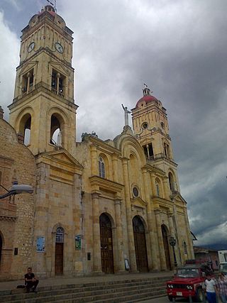
Ibagué is the capital of Tolima, one of the 32 departments that make up the Republic of Colombia. The city is located in the center of the country, on the central mountain range of the Colombian Andes, near Nevado del Tolima. It is one of the most populous cities in the country, with a population of 492,554, making it the eleventh most populous in Colombia, and with a population of 529,625 in the municipality. It was founded on 14 October 1550, by the Spanish captain Andrés López de Galarza. The city of Ibagué is divided into 13 communes and the rural area has 17 corregimientos. As the capital of the department of Tolima the city hosts the Government of Tolima, the Departmental Assembly, and the Attorney General's Office. It is the main epicenter of political, economic, administrative, business, art, culture, and tourism activities in the area.

Salento is a town and municipality in the north-east of the department of Quindío, Colombia. The municipality covers an area of 377.67 km2. It was the first settlement in Quindío of the modern era, and the first municipality founded in the department. The town of Salento itself is located 24 km northeast of the departmental capital Armenia. In 2023 the municipality of Salento had an estimated population of 9,748.
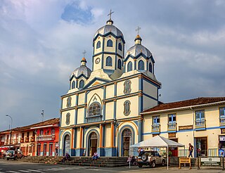
Filandia is a town and municipality in the northern part of the department of Quindío, Colombia. It's located on the west side of Cordillera Central of the Andes mountain range running through central Colombia, 26 km north of the departmental capital Armenia. In 2023 the estimated population of Filandia was 12,596 inhabitants.
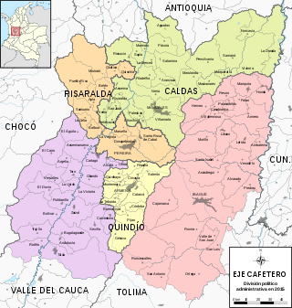
The Colombian coffee region, also known as the Coffee Triangle is a part of the Paisa region in the rural area of Colombia. It is famous for growing and producing the majority of Colombian coffee. There are four departments in the area: Caldas, Quindío, Risaralda and Tolima. The most visited cities are Manizales, Armenia, Pereira, and Ibagué.

The Cordillera Central is the highest of the three branches of the Colombian Andes. The range extends from south to north dividing from the Colombian Massif in Cauca Department to the Serranía de San Lucas in Bolivar Departments. The highest peak is Nevado del Huila at 5,364 m (17,598 ft).

Metepec is a municipality in the State of Mexico in Mexico and is located directly to the east of the state capital, Toluca, at an altitude of 2,635 metres (8,645 ft) above sea level. The center of Mexico City lies some 50 km further to the east. The city of Metepec also form part of the Greater Toluca. The name Metepec comes from Náhuatl meaning hill of the agave plants. However, it is also known in the Matlatzinca language as "Nepinta-Tuhi" meaning 'people of corn land' and in the Otomi language as "Ntaguada".

Tolima is one of the 32 departments of Colombia, located in the Andean region, in the center-west of the country. It is bordered on the north and the west by the department of Caldas; on the east by the department of Cundinamarca; on the south by the department of Huila, and on the west by the departments of Cauca, Valle del Cauca, Quindío and Risaralda. Tolima has a surface area of 23,562 km2, and its capital is Ibagué. The department of Tolima was created in 1861 from a part of what was previously Cundinamarca.

The Nevado del Tolima is a Late Pleistocene to recently active andesitic stratovolcano located in the Tolima department, Colombia. The volcano lies south of Nevado del Ruiz volcano and is situated within the Los Nevados National Natural Park. The volcano, whose most recent activity dates to 1943 and last major eruption around 3600 years ago, overlies the Eocene El Bosque Batholith, dated at 49.1 ± 1.7 Ma.

Líbano is a town and municipality in the Tolima department of Colombia. The population of the municipality was estimated at 36,231 as of 2020. Along with Honda, Líbano is the seat of the Roman Catholic Diocese of Líbano–Honda.

El Cerrito is a town and municipality located in the Department of Valle del Cauca, Colombia. This is one of the 42 municipalities of the department.
La Mesa is a municipality and town of Colombia in the Tequendama Province of the department of Cundinamarca. The urban centre is located 65 kilometres (40 mi) from Bogotá.
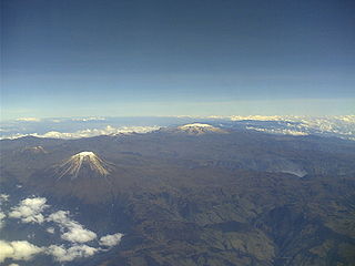
Los Nevados National Natural Park is a national park located in the Cordillera Central of the Colombian Andes. The park surrounds the northern volcanic complex formed by Nevado del Ruiz, Nevado del Tolima, Nevado de Santa Isabel, the paramillos of Cisne, Santa Rosa and Quindío and the Cerro Bravo and Cerro Machín.

Coffee production in Colombia has a reputation for producing mild, well-balanced coffee beans. Colombia's average annual coffee production of 11.5 million bags is the third total highest in the world, after Brazil and Vietnam, though highest in terms of the arabica bean. The beans are exported to United States, Germany, France, Japan, and Italy. Most coffee is grown in the Colombian coffee growing axis region, while other regions focus on quality instead of volumes, such as Sierra Nevada de Santa Marta. In 2007, the European Union granted Colombian coffee a protected designation of origin status. In 2011, UNESCO declared the "Coffee Cultural Landscape" of Colombia, a World Heritage site.

Marianne Vere Cardale de Schrimpff is a Colombian anthropologist, archaeologist, academic and writer.