
Department of Cundinamarca is one of the departments of Colombia. Its area covers 22,623 square kilometres (8,735 sq mi) and it has a population of 2,919,060 as of 2018. It was created on August 5, 1886 under the constitutional terms presented on the same year. Cundinamarca is located in the center of Colombia.

Colombia is a unitary republic made up of thirty-two departments and a Capital District. Each department has a governor (gobernador) and an Assembly, elected by popular vote for a four-year period. The governor cannot be re-elected in consecutive periods. Departments are country subdivisions and are granted a certain degree of autonomy.

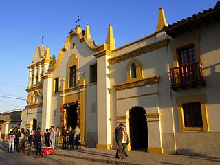
Fusagasugá or Fusa is a town and municipality in the department of Cundinamarca, in central Colombia. It is located in the warm valley between the rivers Cuja and Panches, a central region of the Andes Mountains in South America. The municipality has an estimated population of 134,523 as of 2015. The urban region has 108,157 inhabitants. The municipality itself covers an area of 206 km2 (80 sq mi).

San Cristóbal, is the fourth locality of Bogotá, capital of Colombia. It is located in the southeast of Bogota. This district is mostly inhabited by lower class residents.

Anapoima is a Colombian municipality in the department of Cundinamarca located 87 km (54 mi) from Bogotá.
Bojacá is a municipality and town of the Western Savanna Province, Colombia in the department of Cundinamarca. The urban centre is situated at an altitude of 2,598 metres (8,524 ft) on the Bogotá savanna at 40 kilometres (25 mi) from the capital Bogotá. The municipality borders Zipacón, Madrid and Facatativá in the north, Madrid and Mosquera in the east, Soacha and San Antonio del Tequendama in the south and Tena, La Mesa and Zipacón in the west.

Manta is a municipality and town located in the northeast of the department of Cundinamarca (Colombia), 90 kilometres (56 mi) from Bogotá. It is located in the Almeidas Province in the Tenza Valley. Manta borders to the north Tibiritá, to the west Machetá, to the south Gachetá and to the east Guateque and Guayatá of the department of Boyacá.

Ricaurte is a municipality and town of Colombia in the department of Cundinamarca. A law issued on 14 November 1857 created the Peñalisa District and December of the same year the name was changed to Ricaurte; in 1937 it was annexed to the Girardot municipality but it recovered its condition of municipality in 1968.

San Antonio del Tequendama is a municipality and town of Colombia in the Tequendama Province part of the department of Cundinamarca. The municipality is located along the Serranía de Subía in the Tena Valley and borders Tena and Bojacá in the north, Bojacá and Soacha in the east, La Mesa and El Colegio in the west and in the south Soacha and Granada.

San Francisco de Sales, commonly known as San Francisco, is a municipality and town of Colombia in the department of Cundinamarca.

Subachoque is a municipality and town of Colombia in the Western Savanna Province, part of the department of Cundinamarca. The municipality is situated on the Bogotá savanna with the urban centre at an altitude of 2,663 metres (8,737 ft) at a distance of 45 kilometres (28 mi) from the capital Bogotá. Subachoque is part of the Metropolitan Area of Bogotá and borders Zipaquirá, Tabio and Tenjo in the east, Zipaquirá and Pacho in the north, San Francisco and Supatá in the west and Madrid and El Rosal in the south. Subachoque is composed of 17 subdivisions: Altania, Canica Alta, Canica Baja, Cascajal, El Guamal, El Pantano, El Páramo, El Tobal, Galdámez, La Cuesta, La Pradera, La Unión, La Yegüera, Llanitos, Rincón Santo, Santa Rosa, Tibagota, El Valle.

Villeta is a municipality and town in Cundinamarca (Colombia), located in Gualivá Province, approximately 84 kilometres (52 mi) northwest of Bogota, considered the capital of the province. Its name means "Little Village". The municipality borders Quebradanegra and Nimaima in the north, Nocaima and Sasaima in the east, Albán and Vianí in the south and Guaduas in the west. It is situated at an altitude of 850 metres (2,790 ft) in the Eastern Ranges of the Colombian Andes
Usme is the 5th locality of the Capital District of Bogotá, capital city of Colombia. Usme is located in the south of Bogotá, bordering to the north the localities of San Cristóbal, Rafael Uribe Uribe and Tunjuelito, to the west the locality of Ciudad Bolívar, to the south the locality of Sumapaz, and to the east, behind the Eastern Hills, the municipalities of Ubaque, Chipaque and Une in the Department of Cundinamarca.

Suba is the 11th locality of Bogotá, capital of Colombia. It is located in the northwest of the city, bordering to the north the municipality of Chía in Cundinamarca, to the west the municipality of Cota, to the east the locality Usaquén and to the south the localities Engativá and Barrios Unidos. This district is inhabited by residents of all social classes.
Gualivá Province is one of the 15 provinces in the Cundinamarca Department, Colombia. Gualivá borders the Lower Magdalena Province to the west, to the north the Rionegro Province, to the east and southeast the Western Savanna Province, to the south slightly the Tequendama Province and to the southwest the Central Magdalena Province.

Central Magdalena Province is one of the 15 provinces in the Cundinamarca Department, Colombia. Central Magdalena borders to the west the Tolima Department and the Magdalena River, to the north the Lower Magdalena Province, to the east the Gualivá and Tequendama Provinces and to the south the Upper Magdalena Province.

Piedras del Tunjo is an important archaeological park established on a natural rock shelter 40 kilometres (25 mi) west of Bogotá in the municipality of Facatativá.

The Roman Catholic Diocese of Facatativá is a diocese located in the northwest of Cundinamarca Department in Colombia. Its see is the city of Facatativá; the diocese is part of the ecclesiastical province of Bogotá in Colombia.

Cundinamarca State was one of the states of Colombia. It was created on 15 June 1857 as Estado Federal de Cundinamarca, in 1858 was recognized as Estado de la Federación, and in the constitution of 1863 renamed as Estado Soberano of the United States of Colombia.

The Sumapaz River is a major tributary of the Magdalena River in Colombia. The 95 kilometres (59 mi) long river originates in the Eastern Ranges of the Colombian Andes at the largest páramo in the world; Sumapaz, of which it takes its name. It forms the natural boundary between the departments of Cundinamarca and Tolima.
