The Muisca are an indigenous people and culture of the Altiplano Cundiboyacense, Colombia, that formed the Muisca Confederation before the Spanish conquest. The people spoke Muysccubun, a language of the Chibchan language family, also called Muysca and Mosca. They were encountered by conquistadors dispatched by the Spanish Empire in 1537 at the time of the conquest.
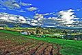
The Altiplano Cundiboyacense is a high plateau located in the Eastern Cordillera of the Colombian Andes covering parts of the departments of Cundinamarca and Boyacá. The altiplano corresponds to the ancient territory of the Muisca. The Altiplano Cundiboyacense comprises three distinctive flat regions; the Bogotá savanna, the valleys of Ubaté and Chiquinquirá, and the valleys of Duitama and Sogamoso. The average altitude of the altiplano is about 2,600 metres (8,500 ft) above sea level but ranges from roughly 2,500 metres (8,200 ft) to 4,000 metres (13,000 ft).

The Tominé Reservoir is a reservoir in northern Cundinamarca, Colombia about 60 kilometres (37 mi) north of Bogotá. It is 18 kilometres (11 mi) long and 4 kilometres (2.5 mi) wide, and when completely filled reaches a maximum depth of 38 metres (125 ft). Its objectives are to control water levels for hydroelectric plants in the region and supply drinking water to Bogotá. It is adjacent to the municipalities of Sesquilé and Guatavita.

Gachancipá is a municipality and town of Colombia in the Central Savanna Province, part of the department of Cundinamarca. The urban centre is located on the Altiplano Cundiboyacense at 42 kilometres (26 mi) from the capital Bogotá. The municipality borders Guatavita and Tocancipá in the south, Sesquilé and Guatavita in the east, Nemocón in the west and Suesca in the north.

Guatavita is a municipality and town of Colombia in the Guavio Province of the department of Cundinamarca. Guatavita is located 75 km northeast of the capital Bogotá. It borders Sesquilé and Machetá in the north, Gachetá and Junín in the east, Guasca in the south and in the west are Tocancipá and Gachancipá.

Machetá is a municipality and town of Colombia in Almeidas Province of the department of Cundinamarca. Machetá is situated on the Altiplano Cundiboyacense at 82.6 kilometres (51.3 mi) from the capital Bogotá and 74.3 kilometres (46.2 mi) from Tunja. It borders Tibiritá and Manta in the east, Chocontá and Sesquilé in the west and Guatavita and Gachetá in the south.

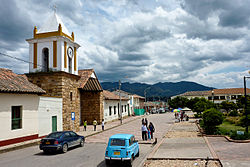
Nemocón is a municipality and town of Colombia in the Central Savanna Province, part of the department of Cundinamarca. Nemocón, famous for its salt mine, was an important village in the Muisca Confederation, the country in the central Colombian Andes before the arrival of the Spanish. The municipality is situated in the northern part of the Bogotá savanna, part of the Altiplano Cundiboyacense with its urban centre at an altitude of 2,585 metres (8,481 ft) and 65 kilometres (40 mi) from the capital Bogotá. Nemocón is the northeasternmost municipality of the Metropolitan Area of Bogotá and the Bogotá River originates close to Nemocón. The median temperature of Nemocón is 12.8 °C. The municipality borders Tausa in the north, Suesca and Gachancipá in the east, Tocancipá and Zipaquirá in the south and in the west the rivers Checua and Neusa and the municipality of Cogua.

Zipacón is a municipality and town of Colombia in the Western Savanna Province, part of the department of Cundinamarca. The urban centre of Zipacón is situated at an altitude of 2,550 metres (8,370 ft) on the Bogotá savanna, the southern flatlands of the Altiplano Cundiboyacense in the Eastern Ranges of the Colombian Andes. Zipacón borders Anolaima, Facatativá, La Mesa and Bojacá.

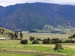
The Bogotá savanna is a montane savanna, located in the southwestern part of the Altiplano Cundiboyacense in the center of Colombia. The Bogotá savanna has an extent of 4,251.6 square kilometres (1,641.6 sq mi) and an average altitude of 2,650 metres (8,690 ft). The savanna is situated in the Eastern Ranges of the Colombian Andes.

Piedras del Tunjo is an important archaeological park established on a natural rock shelter 40 kilometres (25 mi) west of Bogotá in the municipality of Facatativá.

Lake Suesca is a natural water body situated on the Altiplano Cundiboyacense, belonging to the municipalities of Suesca and Cucunubá in the department of Cundinamarca, Colombia. The basin has a semi-elliptical shape that extends on a north–south axis, with roughly 6 kilometres (3.7 mi) length and 2 kilometres (1.2 mi) width. The average depth is 8 metres (26 ft). It is located in the Eastern Ranges, on the anticlinal of Nemocón, in the northeast of the department, at an altitude of 2,800 metres (9,200 ft).
The Muisca Confederation was a loose confederation of different Muisca rulers in the central Andean highlands of what is today Colombia before the Spanish conquest of northern South America. The area, presently called Altiplano Cundiboyacense, comprised the current departments of Boyacá, Cundinamarca and minor parts of Santander.
This article describes the architecture of the Muisca. The Muisca, inhabiting the central highlands of the Colombian Andes, were one of the four great civilizations of the Americas. Unlike the three civilizations in present-day Mexico and Peru, they did not construct grand architecture of solid materials. While specialising in agriculture and gold-working, cloths and ceramics, their architecture was rather modest and made of non-permanent materials as wood and clay.
The Muisca inhabited the Altiplano Cundiboyacense in the Colombian Andes before the arrival of the Spanish and were an advanced civilisation. They mummified the higher social class members of their society, mainly the zipas, zaques, caciques, priests and their families. The mummies would be placed in caves or in dedicated houses ("mausoleums") and were not buried.

Liborio Zerda was a Colombian physician and Muisca scholar. Zerda has been important in the natural sciences of the late 19th and early 20th century in Colombia, publishing many articles about various topics, from medicine to chemical analysis, radioactivity and the popular drink chicha.
This article describes the economy of the Muisca. The Muisca were the original inhabitants of the Altiplano Cundiboyacense, the high plateau in the Eastern Ranges of central present-day Colombia. Their rich economy and advanced merchant abilities were widely known by the indigenous groups of the area and described by the Spanish conquistadores whose primary objective was the acquisition of the mineral resources of Tierra Firme; gold, emeralds, carbon, silver and copper.
The Spanish conquest of the Muisca took place from 1537 to 1540. The Muisca were the inhabitants of the central Andean highlands of Colombia before the arrival of the Spanish conquistadors. They were organised in a loose confederation of different rulers; the psihipqua of Muyquytá, with his headquarters in Funza, the hoa of Hunza, the iraca of the sacred City of the Sun Sugamuxi, the Tundama of Tundama, and several other independent caciques. The most important rulers at the time of the conquest were psihipqua Tisquesusa, hoa Eucaneme, iraca Sugamuxi and Tundama in the northernmost portion of their territories. The Muisca were organised in small communities of circular enclosures, with a central square where the bohío of the cacique was located. They were called "Salt People" because of their extraction of salt in various locations throughout their territories, mainly in Zipaquirá, Nemocón, and Tausa. For the main part self-sufficient in their well-organised economy, the Muisca traded with the European conquistadors valuable products as gold, tumbaga, and emeralds with their neighbouring indigenous groups. In the Tenza Valley, to the east of the Altiplano Cundiboyacense where the majority of the Muisca lived, they extracted emeralds in Chivor and Somondoco. The economy of the Muisca was rooted in their agriculture with main products maize, yuca, potatoes, and various other cultivations elaborated on elevated fields. Agriculture had started around 3000 BCE on the Altiplano, following the preceramic Herrera Period and a long epoch of hunter-gatherers since the late Pleistocene. The earliest archaeological evidence of inhabitation in Colombia, and one of the oldest in South America, has been found in El Abra, dating to around 12,500 years BP.
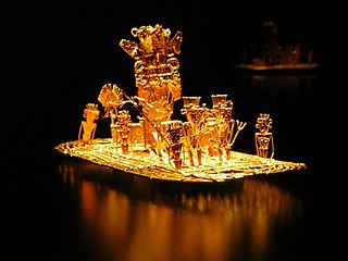
This article describes the art produced by the Muisca. The Muisca established one of the four grand civilisations of the pre-Columbian Americas on the Altiplano Cundiboyacense in present-day central Colombia. Their various forms of art have been described in detail and include pottery, textiles, body art, hieroglyphs and rock art. While their architecture was modest compared to the Inca, Aztec and Maya civilisations, the Muisca are best known for their skilled goldworking. The Museo del Oro in the Colombian capital Bogotá houses the biggest collection of golden objects in the world, from various Colombian cultures including the Muisca.