Aguazuque

Last updated
Aguazuque
Colombia relief location map.jpg
Archaeological site icon (red).svg
Location within Colombia
Location Soacha, Cundinamarca
Region Bogotá savanna,
Altiplano Cundiboyacense,
Flag of Colombia.svg  Colombia
Coordinates 4°36′08″N74°16′35″W / 4.60222°N 74.27639°W / 4.60222; -74.27639
Altitude2,601 m (8,533 ft)
TypeOpen area settlement
Part of Pre-Muisca sites
Area76 m2 (820 sq ft)
History
Periods Andean preceramic-Herrera
CulturesHerrera
Site notes
Archaeologists Correal
Public accessYes

Aguazuque is a pre-Columbian archaeological site located in the western part of the municipality Soacha, close to the municipalities Mosquera and San Antonio del Tequendama in Cundinamarca, Colombia. It exists of evidences of human settlement of hunter-gatherers and in the ultimate phase primitive farmers. The site is situated on the Bogotá savanna, the relatively flat highland of the Altiplano Cundiboyacense close to the present-day course of the Bogotá River at an altitude of 2,600 metres (8,500 ft) above sea level. Aguazuque is just north of another Andean preceramic archaeological site; the rock shelter Tequendama and a few kilometres south of Lake Herrera. The artefacts found mostly belong to the preceramic period, and have been dated to 5025 to 2725 BP (3000 to 700 BCE). Thus, the younger finds also pertain to the later ceramic Herrera Period. There were some difficulties in dating of the uppermost layer due to modern agricultural activity in the area; the sediments of the shallower parts were disturbed.

Contents

At Aguazuque multiple palaeoanthropological finds have been made; stone and bone tools, remains of fireplaces and a multitude of pre-Columbian foods, primitive circular housing, various burial sites of individual and group interments and in the youngest dated layers, evidences of ceramics.

The site represents a transition from a hunter-gatherer culture towards the earliest evidence of agriculture. A phase of settlement is attested where the people moved away from the caves and rock shelters and started inhabiting open area grounds.

Investigation of Aguazuque has been conducted since 1986, mainly by archaeologist Gonzalo Correal Urrego who published the results of his studies in the book Aguazuque - evidencias de cazadores, recolectores y plantadores en la altiplanicie de la Cordillera Oriental in 1990. [1] [2]

Etymology

The site Aguazuque is named after the Hacienda Aguazuque that was built west of the capital Bogotá in the early 17th century. [3]

Background

Sabana de Bogota.png
Yellow pog.svg
Aguazuque and other preceramic sites on the Bogotá savanna

The history of inhabitation of the Altiplano Cundiboyacense goes back to the prehistorical era. The oldest dated evidence of human settlement on the high plateau in the Eastern Ranges of the Colombian Andes has been found in El Abra, within the municipality of Zipaquirá, Cundinamarca. At this rock shelter on the northern edge of the Bogotá savanna, stone tools and chopper cores have been carbon dated at 12,500 years BP. Other early sites of inhabitation of the area have been discovered at Tibitó (11,400 BP), Tequendama (11,000 BP) and Checua (8500 BP), with later settlements in Mosquera (3135 BP), Chía (3120 BP), Junín, Zipacón and Tausa. [4] [5] Younger ceramic artefacts were found around Lake Herrera, the namesake of the Herrera Period that is defined as from 800 BC to 800 AD. [6] The period from 800 to 1537 AD, when the Spanish conquered this area, is characterised by one of the four grand civilisations of the Americas; the Muisca period.

Soacha, today the most populated satellite city of the Colombian capital, was an important location for pre-Columbian settlement. Apart from Aguazuque, various other sites have been discovered in the vicinity of Soacha. For example, in 2014, the largest pre-Columbian town has been discovered in Soacha, with the remains of 2200 people, more than 600 ceramic pots and various spindles and tunjos . [7] [8] [9] [10]

The name Soacha is derived from the Muysccubun words for Sun; Súa (with the Sun god Sué) and man; chá. [11]

Aguazuque

The elaboration of stone tools was performed using other pieces of chert Talla litica.png
The elaboration of stone tools was performed using other pieces of chert

The archaeological remains of Aguazuque were found in an oval elevated area west of the Bogotá River, that forms a bend around this higher ground. Aguazuque is located on the southwestern part of the Bogotá savanna and is surrounded by higher hills reaching altitudes of up to 2,850 metres (9,350 ft). The climate is cool, with an average temperature of 13 °C (55 °F). [12] Compared to other parts of the Bogotá savanna, the area of Aguazuque has relatively little rainfall. [13] Geologically, Aguazuque is located on an anticlinal part of the Eastern Ranges with sandstones of the Late Cretaceous Guadalupe Group outcropping nearby. The top sediments are of Late Pleistocene and early Holocene age and contain sandstones and claystones of the former Lake Humboldt and various beds of volcanic ash. Fossil remains of Pleistocene megafauna have been found in Mosquera and were dated to 20,000 years BP. [14] The area of the site is 76 square metres (820 sq ft) and remains have been analysed to a depth of 2 metres (6.6 ft). [15]

Artefacts

The stone artefacts uncovered are very similar in character to those found at El Abra and Tequendama and consist of tools mainly made of chert from the Guadalupe Group. The tools comprise various kinds of scrapers, knives, perforating tools, burins, spokeshaves, maceheads and round mortars and flat milling stones. Most of the artefacts originate from the nearby chert, with some tools made from shales of the Villeta Group and more allochthonous basalt tools, coming from farther west, around the Magdalena River, provenance of the Central Ranges of the Colombian Andes. [16] Apart from tools, Aguazuque is characterised by a large percentage of flakes resulting from the lithic reduction; the process of elaboration of the tools; in total 3868 samples, between 60 and 70% of the lithic fragments found were of this type. [17]

Other artefacts found were made of bones and shells, such as beads, spear points, perforating tools, knives and scrapers. The latter formed the majority of bone tools found, accounting for 55 to 75% of the bone artefacts found. [18]

Flora, fauna and diet

White-tailed deer formed the main meat in the diet of the inhabitants of Aguazuque White-tailed Deer (Odocoileus virginianus) (15498893548).jpg
White-tailed deer formed the main meat in the diet of the inhabitants of Aguazuque

In all of the layers of the Aguazuque site, remains of fauna have been uncovered. The fauna, part of the cuisine of the inhabitants of Aguazuque, consisted of mammals, reptiles, birds, fish and invertebrates such as gastropods, fresh water oysters and crustaceans.

As at the other sites on the Altiplano Cundiboyacense, the main part of the diet of the people was formed by white-tailed deer (Odocoileus virginianus). Other mammals included little red brocket (Mazama rufina), guinea pigs (Cavia porcellus), nine-banded armadillo (Dasypus novemcinctus), white-lipped peccary (Tayassu pecari), crab-eating fox (Dusicyon thous), spectacled bear (Tremarctos ornatus), ocelot (Felis pardalis), puma (Felis concolor), lowland paca (Agouti paca), Agouti taczamawskii , Dasyprocta , ring-tailed coati (Nasua nasua), western mountain coati ( Nasuella olivacea ), common opossum (Didelphis marsupialis) and collared anteater (Tamandua tetradactyla). [19] Reptiles consisted of the turtle Kinosternon postinginale and remains of caimans, indicating hunting in terrains much farther to the west; the Magdalena River. [20] [21]

Fish was coming from the various lakes, rivers and wetlands dotting the Bogotá savanna, that originally were part of Lake Humboldt. Fish remains consisted of Eremophilus mutisii , Pygidium bogotense and Grundulus bogotensis . [20] Bird remains included the Andean guan (Penelope montagnii), Anatidae , Ralidae and the scaly-naped parrot (Amazona mercenaria). [20] The invertebrates comprised Drymaeus gratus , Plekocheilus coloratus , Plekocheilus succionoides , fresh water oysters and fresh water crabs of the family Pseudothelfhusidae , possibly Neostrengeria magropa . [22]

In terms of species of flora, Aguazuque has provided evidence of early agriculture, based on seeds of Cucurbita pepo . [23] Other plant remains were analysed as Hieronyma macrocarpa , Oxalis tuberosa , Dioscorea trífida and various remains of Bromeliaceae , Rubiaceae and Gramineae . Species of mushrooms suggest their addition to the diet of the hunter-gatherers of Aguazuque. [24]

Burial sites

Stone mortars were used to grind pigments, prepare food and as pieces for the dead, evidenced in various burial sites at Aguazuque COLLECTIE TROPENMUSEUM Kleine mortier van steen TMnr 3433-3.jpg
Stone mortars were used to grind pigments, prepare food and as pieces for the dead, evidenced in various burial sites at Aguazuque

Within the area of Aguazuque, fifty-nine burial sites have been discovered, consisting of single, double and mass graves. The bodies were buried on either the right or the left side, or lying on their backs. As was common in the later Muisca mummification culture, the bodies were interred with their arms crossed over the thorax and the legs folded onto the abdomen.

One of the collective sites contained the remains of 23 adults (men and women) and children. [25] It has been theorised that these people fell victim to epidemics, of which in the remains no traces were found. [26] The burial sites showed evidence of ritual and beliefs in afterlife; the bodies were surrounded by stone tools, such as scrapers and mortars, and some pieces were decorated with red or black colours. Food offerings, such as the meat of the white-tailed deer, guinea pigs and Tayassu pecari accompanied the buried. [27] An isolated body was adorned with colourful painted pieces of rock. [28] Similar to what has been found in Tequendama, some of the buried people may have been characterised by rituals of cannibalism. [29] This is evidenced further by the discovery of mutilated and coloured skeletal remains in Aguazuque. [30]

Paleopathological analysis has provided information on the people; the average brain volume was around 1,400 cubic centimetres (85 cu in), spread from 1,240 cubic centimetres (76 cu in) to 1,480 cubic centimetres (90 cu in) and the body length around 160 centimetres (63 in). [31] Osteoarthritis has been found in 73% of the individuals and other diseases such as syphilis, treponematosis, osteoperiostitis and osteoperosis were common. [32] Different from remains of similar age found on the Altiplano, such as Gachalá, Nemocón and Tequendama, where no evidence of caries was discovered, in Aguazuque the human dental remains showed ample evidence of caries. [33] Electron paramagnetic resonance of tooth enamel has provided an age of 3256 ± 196 years BP. [34]

Burial sites of animals have also been found, where turtles, parrots and foxes were located in isolated small graves. [35]

History of settlement

Aguazuque is situated close to the Bogota River, on the right bank (north), just east of the Salto del Tequendama Rio Bogota map.png
Aguazuque is situated close to the Bogotá River, on the right bank (north), just east of the Salto del Tequendama

The evidence for human settlements at Aguazuque consists of circular slightly excavated structures, surrounded by vertically inward inclined bones of deer, or poles of wood. The round areas had a diameter of between 2 metres (6.6 ft) and 4 metres (13 ft) and contained ash and carbon remains on the floor. Using animal and shell pigments, the floors were painted red or covered with sandstone fragments and volcanic ash. The remains of the houses were mostly circular, and near them were many fireplaces. [36]

The oldest evidence for settlement has been dated to 5025 ± 40 years Before Present (around 3000 BCE). This layer is followed by younger occupation dated at 3850 ± 35 years, 3400 to 2800 BP and the second-youngest zone at 2725 ± 35 years BP. The uppermost layer has been disturbed by modern agricultural activity and provided no dates. The different layers of Aguazuque were similar in character in terms of the tools found, and in the abundance of deer, the main meat for the inhabitants of the Bogotá savanna. The sequence of the layers from bottom to top based on the abundance of guinea pig remains, showed that their presence as domesticated animals varied through time. The domestication of guinea pigs is also evidenced in nearby Tequendama.

The percentage of hunted deer was highest in the uppermost layer where the caiman bones have also been found, suggesting a time of greater interaction with the lower altitude tropical zones of the Andes. The early evidence for agriculture has been found in the middle section of the sequence, as has been discovered in Zipacón where the agricultural activity has been dated at 3270 years BP. [37] Only in the uppermost beds, the evidence of ceramics has been found, that could be dated to Early Herrera; around 2800 years BP. [38]

Named after Aguazuque

Aguazuque is featured as one of the names appearing in the grand-strategy video game Europa Universalis IV in the playable nation of the Muisca. [39]

See also

Related Research Articles

<span class="mw-page-title-main">Altiplano Cundiboyacense</span> Plateau in the Columbian Andes

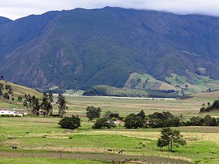
The Altiplano Cundiboyacense is a high plateau located in the Eastern Cordillera of the Colombian Andes covering parts of the departments of Cundinamarca and Boyacá. The altiplano corresponds to the ancient territory of the Muisca. The Altiplano Cundiboyacense comprises three distinctive flat regions; the Bogotá savanna, the valleys of Ubaté and Chiquinquirá, and the valleys of Duitama and Sogamoso. The average altitude of the altiplano is about 2,600 metres (8,500 ft) above sea level but ranges from roughly 2,500 metres (8,200 ft) to 4,000 metres (13,000 ft).

<span class="mw-page-title-main">Bojacá</span> Municipality and town in Cundinamarca, Colombia

Bojacá is a municipality and town of the Western Savanna Province, Colombia in the department of Cundinamarca. The urban centre is situated at an altitude of 2,598 metres (8,524 ft) on the Bogotá savanna at 40 kilometres (25 mi) from the capital Bogotá. The municipality borders Zipacón, Madrid and Facatativá in the north, Madrid and Mosquera in the east, Soacha and San Antonio del Tequendama in the south and Tena, La Mesa and Zipacón in the west.

<span class="mw-page-title-main">Nemocón</span> Place in Cundinamarca, Colombia

Nemocón is a municipality and town of Colombia in the Central Savanna Province, part of the department of Cundinamarca. Nemocón, famous for its salt mine, was an important village in the Muisca Confederation, the country in the central Colombian Andes before the arrival of the Spanish. The municipality is situated in the northern part of the Bogotá savanna, part of the Altiplano Cundiboyacense with its urban centre at an altitude of 2,585 metres (8,481 ft) and 65 kilometres (40 mi) from the capital Bogotá. Nemocón is the northeasternmost municipality of the Metropolitan Area of Bogotá and the Bogotá River originates close to Nemocón. The median temperature of Nemocón is 12.8 °C. The municipality borders Tausa in the north, Suesca and Gachancipá in the east, Tocancipá and Zipaquirá in the south and in the west the rivers Checua and Neusa and the municipality of Cogua.

<span class="mw-page-title-main">El Abra</span> Archeological site

El Abra is the name given to an extensive archeological site, located in the valley of the same name. El Abra is situated in the east of the municipality Zipaquirá extending to the westernmost part of Tocancipá in the department of Cundinamarca, Colombia. The several hundred metres long series of rock shelters is in the north of the Bogotá savanna on the Altiplano Cundiboyacense, Eastern Ranges of the Colombian Andes at an altitude of 2,570 metres (8,430 ft). The rock shelter and cave system is one of the first evidences of human settlement in the Americas, dated at 12,400 ± 160 years BP. The site was used by the hunter-gatherers of the Late Pleistocene epoch.

<span class="mw-page-title-main">Bogotá savanna</span> Motane savanna in Altiplano Cundiboyacense

The Bogotá savanna is a montane savanna, located in the southwestern part of the Altiplano Cundiboyacense in the center of Colombia. The Bogotá savanna has an extent of 4,251.6 square kilometres (1,641.6 sq mi) and an average altitude of 2,650 metres (8,690 ft). The savanna is situated in the Eastern Ranges of the Colombian Andes.

<span class="mw-page-title-main">Piedras del Tunjo Archaeological Park</span> Archaeological park

Piedras del Tunjo is an important archaeological park established on a natural rock shelter 40 kilometres (25 mi) west of Bogotá in the municipality of Facatativá.

<span class="mw-page-title-main">Bacatá</span> Area on the Bogotá Savannah

Bacatá is the name given to the main settlement of the Muisca Confederation on the Bogotá savanna. It mostly refers to an area, rather than an individual village, although the name is also found in texts referring to the modern settlement of Funza, in the centre of the savanna. Bacatá was the main seat of the zipa, the ruler of the Bogotá savanna and adjacent areas. The name of the Colombian capital, Bogotá, is derived from Bacatá, but founded as Santafe de Bogotá in the western foothills of the Eastern Hills in a different location than the original settlement Bacatá, west of the Bogotá River, eventually named after Bacatá as well.

<span class="mw-page-title-main">Muisca Confederation</span> Former Andean highlands confederation

The Muisca Confederation was a loose confederation of different Muisca rulers in the central Andean highlands of what is today Colombia before the Spanish conquest of northern South America. The area, presently called Altiplano Cundiboyacense, comprised the current departments of Boyacá, Cundinamarca and minor parts of Santander.

<span class="mw-page-title-main">Gonzalo Correal Urrego</span>

Gonzalo Correal Urrego is a Colombian anthropologist, palaeontologist and archaeologist. He has been contributing to the knowledge of prehistoric Colombia for over forty years and has published in Spanish and English. Correal Urrego is considered one of the most important anthropologists of Colombia. He has collaborated with many other anthropologists and archaeologists, among others Thomas van der Hammen and Ana María Groot.

<span class="mw-page-title-main">Herrera Period</span> Period of Colombian history

The Herrera Period is a phase in the history of Colombia. It is part of the Andean preceramic and ceramic, time equivalent of the North American pre-Columbian formative and classic stages and age dated by various archaeologists. The Herrera Period predates the age of the Muisca, who inhabited the Altiplano Cundiboyacense before the Spanish conquest of the Muisca and postdates the prehistory of the region in Colombia. The Herrera Period is usually defined as ranging from 800 BCE to 800 CE, although some scholars date it as early as 1500 BCE.

<span class="mw-page-title-main">Tequendama</span> Archaeological site in Columbia

Tequendama is a preceramic and ceramic archaeological site located southeast of Soacha, Cundinamarca, Colombia, a couple of kilometers east of Tequendama Falls. It consists of multiple evidences of late Pleistocene to middle Holocene population of the Bogotá savanna, the high plateau in the Colombian Andes. Tequendama was inhabited from around 11,000 years BP, and continuing into the prehistorical, Herrera and Muisca periods, making it the oldest site of Colombia, together with El Abra, located north of Zipaquirá. Younger evidences also from the Herrera Period have been found close to the site of Tequendama in Soacha, at the construction site of a new electrical plant. They are dated at around 900 BCE to 900 AD.

<span class="mw-page-title-main">Muisca agriculture</span>

The Muisca agriculture describes the agriculture of the Muisca, the advanced civilisation that was present in the times before the Spanish conquest on the high plateau in the Colombian Andes; the Altiplano Cundiboyacense. The Muisca were a predominantly agricultural society with small-scale farmfields, part of more extensive terrains. To diversify their diet, they traded mantles, gold, emeralds and salt for fruits, vegetables, coca, yopo and cotton cultivated in lower altitude warmer terrains populated by their neighbours, the Muzo, Panche, Guane, Guayupe, Lache, Sutagao and U'wa. Trade of products grown farther away happened with the Calima, Pijao and Caribbean coastal communities around the Sierra Nevada de Santa Marta.

<span class="mw-page-title-main">Muisca architecture</span>

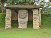
This article describes the architecture of the Muisca. The Muisca, inhabiting the central highlands of the Colombian Andes, were one of the four great civilizations of the Americas. Unlike the three civilizations in present-day Mexico and Peru, they did not construct grand architecture of solid materials. While specialising in agriculture and gold-working, cloths and ceramics, their architecture was rather modest and made of non-permanent materials as wood and clay.

Lake Herrera is a small lake located at 5 kilometres (3.1 mi) from the urban centre of Mosquera and about 20 kilometres (12 mi) west of the capital Bogotá in Cundinamarca, Colombia. The Andean lake has made its name in the Herrera Period, the period in the history of central Colombia before the Muisca Period, after archaeologist Sylvia Broadbent excavated ceramics around Lake Herrera in 1971.

<span class="mw-page-title-main">Muisca art</span> Pre-Columbian art

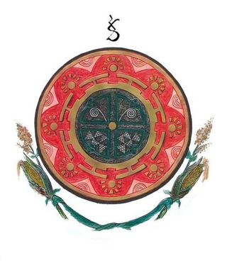
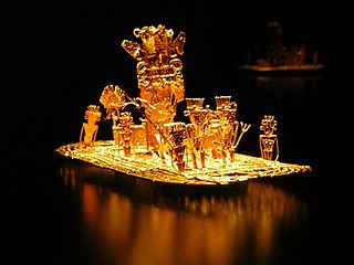
This article describes the art produced by the Muisca. The Muisca established one of the four grand civilisations of the pre-Columbian Americas on the Altiplano Cundiboyacense in present-day central Colombia. Their various forms of art have been described in detail and include pottery, textiles, body art, hieroglyphs and rock art. While their architecture was modest compared to the Inca, Aztec and Maya civilisations, the Muisca are best known for their skilled goldworking. The Museo del Oro in the Colombian capital Bogotá houses the biggest collection of golden objects in the world, from various Colombian cultures including the Muisca.

Tibitó is the second-oldest dated archaeological site on the Altiplano Cundiboyacense, Colombia. The rock shelter is located in the municipality Tocancipá, Cundinamarca, Colombia, in the northern part of the Bogotá savanna. At Tibitó, bone and stone tools and carbon have been found. Bones from Haplomastodon, Cuvieronius, Cerdocyon and white tailed deer from the deepest human trace containing layer of the site is carbon dated to be 11,740 ± 110 years old. The oldest dated sediments are lacustrine clays from an ancient Pleistocene lake.

Checua is a preceramic open area archaeological site in Nemocón, Cundinamarca, Colombia. The site is located 7 kilometres (4.3 mi) north of the town centre. At Checua, thousands of stone and bone tools, stone flakes and human remains have been found, indicating human occupation from around 8500 to 3000 years BP.

<span class="mw-page-title-main">Eastern Hills (Bogotá)</span> Chain of hills forming Bogotás eastern boundary

The Eastern Hills are a chain of hills forming the eastern natural boundary of the Colombian capital Bogotá. They are part of the Altiplano Cundiboyacense, the high plateau of the Eastern Ranges of the Colombian Andes. The Eastern Hills are bordered by the Chingaza National Natural Park to the east, the Bogotá savanna to the west and north, and the Sumapaz Páramo to the south. The north-northeast to south-southwest trending mountain chain is 52 kilometres (32 mi) long and its width varies from 0.4 to 8 kilometres. The highest hilltops rise to 3,600 metres (11,800 ft) over the western flatlands at 2,600 metres (8,500 ft). The Torca River at the border with Chía in the north, the boquerón Chipaque to the south and the valley of the Teusacá River to the east are the hydrographic limits of the Eastern Hills.

<span class="mw-page-title-main">Sabana Formation</span> Geological formation in the Colombian Andes

The Sabana Formation is a geological formation of the Bogotá savanna, Altiplano Cundiboyacense, Eastern Ranges of the Colombian Andes. The formation consists mainly of shales with at the edges of the Bogotá savanna lignites and sandstones. The Sabana Formation dates to the Quaternary period; Middle to Late Pleistocene epoch, and has a maximum thickness of 320 metres (1,050 ft), varying greatly across the savanna. It is the uppermost formation of the lacustrine and fluvio-glacial sediments of paleolake Humboldt, that existed at the edge of the Eastern Hills until the latest Pleistocene.

References

  1. (in Spanish) La colonia vive en Canoas - El Tiempo
  2. (in Spanish) Curriculum Vitae Gonzalo Correal Urrego Archived 2016-10-11 at the Wayback Machine
  3. Correal Urrego, 1990, p. 21
  4. Correal Urrego, 1990, p. 9
  5. Groot de Mahecha, 1992
  6. (in Spanish) Chronology of pre-Columbian periods: Herrera and Muisca
  7. (in Spanish) Herrera Period evidence in Soacha - El Espectador
  8. (in Spanish) Largest Herrera Period village in Soacha Archived 2016-06-25 at the Wayback Machine
  9. Archaeologists uncover remains of pre-Columbian village in central Colombia
  10. (in Spanish) Dating of the Soacha Herrera Period site Archived 2016-10-10 at the Wayback Machine
  11. (in Spanish) Official website Soacha Archived 2016-02-13 at the Wayback Machine
  12. Correal Urrego, 1990, p. 13
  13. Correal Urrego, 1990, p. 14
  14. Correal Urrego, 1990, p. 16
  15. Correal Urrego, 1990, p. 23
  16. Correal Urrego, 1990, p. 30
  17. Correal Urrego, 1990, pp. 35–53
  18. Correal Urrego, 1990, pp. 54–78
  19. Correal Urrego, 1990, p. 79
  20. 1 2 3 Correal Urrego, 1990, p. 80
  21. Correal Urrego, 1990, p. 263
  22. Correal Urrego, 1990, p. 113
  23. Correal Urrego, 1990, p.248
  24. Correal Urrego, 1990, pp. 249–250
  25. Correal Urrego, 1990, p. 139
  26. Correal Urrego, 1990, p. 259
  27. Correal Urrego, 1990, p. 141
  28. Correal Urrego, 1990, p. 142
  29. Correal Urrego, 1990, p. 152
  30. Correal Urrego, 1990, p.153
  31. Correal Urrego, 1990, pp.165–194
  32. Correal Urrego, 1990, pp. 198–222
  33. Correal Urrego, 1990, p. 231
  34. Datación de restos fósiles humanos provenientes de Aguazuque y Checua (Cundinamarca) usando resonancia paramagnética electrónica (epr) - abstract - Universidad Nacional
  35. Correal Urrego, 1990, p. 237
  36. Correal Urrego, 1990, pp. 237–244
  37. Correal Urrego, 1990, pp. 256–264
  38. Correal Urrego, 1990, p. 264
  39. Muisca names Europa Universalis IV - GitHub

Bibliography