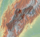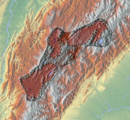
The Altiplano Cundiboyacense is a high plateau located in the Eastern Cordillera of the Colombian Andes covering parts of the departments of Cundinamarca and Boyacá. The altiplano corresponds to the ancient territory of the Muisca. The Altiplano Cundiboyacense comprises three distinctive flat regions; the Bogotá savanna, the valleys of Ubaté and Chiquinquirá, and the valleys of Duitama and Sogamoso. The average altitude of the altiplano is about 2,600 metres (8,500 ft) above sea level but ranges from roughly 2,500 metres (8,200 ft) to 4,000 metres (13,000 ft).
Bojacá is a municipality and town of the Western Savanna Province, Colombia in the department of Cundinamarca. The urban centre is situated at an altitude of 2,598 metres (8,524 ft) on the Bogotá savanna at 40 kilometres (25 mi) from the capital Bogotá. The municipality borders Zipacón, Madrid and Facatativá in the north, Madrid and Mosquera in the east, Soacha and San Antonio del Tequendama in the south and Tena, La Mesa and Zipacón in the west.

Nemocón is a municipality and town of Colombia in the Central Savanna Province, part of the department of Cundinamarca. Nemocón, famous for its salt mine, was an important village in the Muisca Confederation, the country in the central Colombian Andes before the arrival of the Spanish. The municipality is situated in the northern part of the Bogotá savanna, part of the Altiplano Cundiboyacense with its urban centre at an altitude of 2,585 metres (8,481 ft) and 65 kilometres (40 mi) from the capital Bogotá. Nemocón is the northeasternmost municipality of the Metropolitan Area of Bogotá and the Bogotá River originates close to Nemocón. The median temperature of Nemocón is 12.8 °C. The municipality borders Tausa in the north, Suesca and Gachancipá in the east, Tocancipá and Zipaquirá in the south and in the west the rivers Checua and Neusa and the municipality of Cogua.

El Abra is the name given to an extensive archeological site, located in the valley of the same name. El Abra is situated in the east of the municipality Zipaquirá extending to the westernmost part of Tocancipá in the department of Cundinamarca, Colombia. The several hundred metres long series of rock shelters is in the north of the Bogotá savanna on the Altiplano Cundiboyacense, Eastern Ranges of the Colombian Andes at an altitude of 2,570 metres (8,430 ft). The rock shelter and cave system is one of the first evidences of human settlement in the Americas, dated at 12,400 ± 160 years BP. The site was used by the hunter-gatherers of the Late Pleistocene epoch.

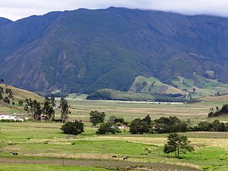
The Bogotá savanna is a montane savanna, located in the southwestern part of the Altiplano Cundiboyacense in the center of Colombia. The Bogotá savanna has an extent of 4,251.6 square kilometres (1,641.6 sq mi) and an average altitude of 2,650 metres (8,690 ft). The savanna is situated in the Eastern Ranges of the Colombian Andes.

Bacatá is the name given to the main settlement of the Muisca Confederation on the Bogotá savanna. It mostly refers to an area, rather than an individual village, although the name is also found in texts referring to the modern settlement of Funza, in the centre of the savanna. Bacatá was the main seat of the zipa, the ruler of the Bogotá savanna and adjacent areas. The name of the Colombian capital, Bogotá, is derived from Bacatá, but founded as Santafe de Bogotá in the western foothills of the Eastern Hills in a different location than the original settlement Bacatá, west of the Bogotá River, eventually named after Bacatá as well.
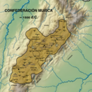
The Muisca Confederation was a loose confederation of different Muisca rulers in the central Andean highlands of what is today Colombia before the Spanish conquest of northern South America. The area, presently called Altiplano Cundiboyacense, comprised the current departments of Boyacá, Cundinamarca and minor parts of Santander.

Tequendama is a preceramic and ceramic archaeological site located southeast of Soacha, Cundinamarca, Colombia, a couple of kilometers east of Tequendama Falls. It consists of multiple evidences of late Pleistocene to middle Holocene population of the Bogotá savanna, the high plateau in the Colombian Andes. Tequendama was inhabited from around 11,000 years BP, and continuing into the prehistorical, Herrera and Muisca periods, making it the oldest site of Colombia, together with El Abra, located north of Zipaquirá. Younger evidences also from the Herrera Period have been found close to the site of Tequendama in Soacha, at the construction site of a new electrical plant. They are dated at around 900 BCE to 900 AD.
The Muisca agriculture describes the agriculture of the Muisca, the advanced civilisation that was present in the times before the Spanish conquest on the high plateau in the Colombian Andes; the Altiplano Cundiboyacense. The Muisca were a predominantly agricultural society with small-scale farmfields, part of more extensive terrains. To diversify their diet, they traded mantles, gold, emeralds and salt for fruits, vegetables, coca, yopo and cotton cultivated in lower altitude warmer terrains populated by their neighbours, the Muzo, Panche, Guane, Guayupe, Lache, Sutagao and U'wa. Trade of products grown farther away happened with the Calima, Pijao and Caribbean coastal communities around the Sierra Nevada de Santa Marta.
This article describes the architecture of the Muisca. The Muisca, inhabiting the central highlands of the Colombian Andes, were one of the four great civilizations of the Americas. Unlike the three civilizations in present-day Mexico and Peru, they did not construct grand architecture of solid materials. While specialising in agriculture and gold-working, cloths and ceramics, their architecture was rather modest and made of non-permanent materials as wood and clay.
Lake Herrera is a small lake located at 5 kilometres (3.1 mi) from the urban centre of Mosquera and about 20 kilometres (12 mi) west of the capital Bogotá in Cundinamarca, Colombia. The Andean lake has made its name in the Herrera Period, the period in the history of central Colombia before the Muisca Period, after archaeologist Sylvia Broadbent excavated ceramics around Lake Herrera in 1971.

Liborio Zerda was a Colombian physician and Muisca scholar. Zerda has been important in the natural sciences of the late 19th and early 20th century in Colombia, publishing many articles about various topics, from medicine to chemical analysis, radioactivity and the popular drink chicha.
This article describes the economy of the Muisca. The Muisca were the original inhabitants of the Altiplano Cundiboyacense, the high plateau in the Eastern Ranges of central present-day Colombia. Their rich economy and advanced merchant abilities were widely known by the indigenous groups of the area and described by the Spanish conquistadores whose primary objective was the acquisition of the mineral resources of Tierra Firme; gold, emeralds, carbon, silver and copper.

Marianne Vere Cardale de Schrimpff is a Colombian anthropologist, archaeologist, academic and writer.
Aguazuque is a pre-Columbian archaeological site located in the western part of the municipality Soacha, close to the municipalities Mosquera and San Antonio del Tequendama in Cundinamarca, Colombia. It exists of evidences of human settlement of hunter-gatherers and in the ultimate phase primitive farmers. The site is situated on the Bogotá savanna, the relatively flat highland of the Altiplano Cundiboyacense close to the present-day course of the Bogotá River at an altitude of 2,600 metres (8,500 ft) above sea level. Aguazuque is just north of another Andean preceramic archaeological site; the rock shelter Tequendama and a few kilometres south of Lake Herrera. The artefacts found mostly belong to the preceramic period, and have been dated to 5025 to 2725 BP. Thus, the younger finds also pertain to the later ceramic Herrera Period. There were some difficulties in dating of the uppermost layer due to modern agricultural activity in the area; the sediments of the shallower parts were disturbed.
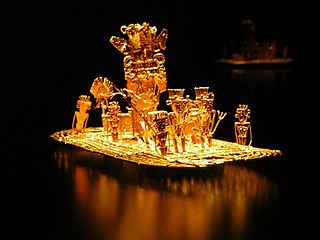
This article describes the art produced by the Muisca. The Muisca established one of the four grand civilisations of the pre-Columbian Americas on the Altiplano Cundiboyacense in present-day central Colombia. Their various forms of art have been described in detail and include pottery, textiles, body art, hieroglyphs and rock art. While their architecture was modest compared to the Inca, Aztec and Maya civilisations, the Muisca are best known for their skilled goldworking. The Museo del Oro in the Colombian capital Bogotá houses the biggest collection of golden objects in the world, from various Colombian cultures including the Muisca.
Tibitó is the second-oldest dated archaeological site on the Altiplano Cundiboyacense, Colombia. The rock shelter is located in the municipality Tocancipá, Cundinamarca, Colombia, in the northern part of the Bogotá savanna. At Tibitó, bone and stone tools and carbon have been found. Bones from Haplomastodon, Cuvieronius, Cerdocyon and white tailed deer from the deepest human trace containing layer of the site is carbon dated to be 11,740 ± 110 years old. The oldest dated sediments are lacustrine clays from an ancient Pleistocene lake.
Checua is a preceramic open area archaeological site in Nemocón, Cundinamarca, Colombia. The site is located 7 kilometres (4.3 mi) north of the town centre. At Checua, thousands of stone and bone tools, stone flakes and human remains have been found, indicating human occupation from around 8500 to 3000 years BP.