-
 Rock shelters
 -
 Open area settlements
 -
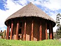
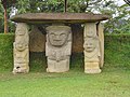
 Constructed sites
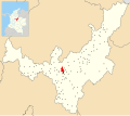
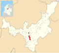
- A - El Abra
- Ti - Tibitó
- Su - Sueva
- Te - Tequendama
- C - Checua/Nemocón
- Ag - Aguazuque
- Sa - Sáchica
- H - Lake Herrera
- I - El Infiernito
- ST - Sun Temple
- CZ - Cojines del Zaque
This is a list of Muisca and pre-Muisca archaeological sites; sites on the Altiplano Cundiboyacense, where archaeological evidence has been discovered of the Muisca and their ancestors of the Herrera, preceramic and prehistorical periods.
Contents
- Background
- Timeline of inhabitation
- List of Muisca and pre-Muisca sites
- See also
- References
- Bibliography
- Further reading
Over the course of the centuries and mainly in the 21st century, many sites with evidences of Muisca and pre-Muisca presence have been found and reported. [1] [2] [3] [4] [5]
The possibly oldest evidence of human settlement in the Eastern Ranges of the Colombian Andes has been discovered just west of the former Muisca territories, at Pubenza in Tocaima, Cundinamarca. Eight stone tools have been found with bone remains, consisting of among others Haplomastodon and turtles, which have been dated at 16,400 ± 420 years BP. Due to the location at an inundated platform, it is unclear if the bones and thus age were in situ . [6]