Municipalities of Colombia

Last updated
Municipalities of Colombia Mapa de Colombia (+municipios).svg
Municipalities of Colombia

The municipalities of Colombia are decentralized subdivisions of the Republic of Colombia. Municipalities make up most of the departments of Colombia with 1,122 municipalities ( municipios ). Each one of them is led by a mayor (alcalde) elected by popular vote and represents the maximum executive government official at a municipality level under the mandate of the governor of their department which is a representative of all municipalities in the department; municipalities are grouped to form departments.

Contents

The municipalities of Colombia are also grouped in an association called the Federación Colombiana de Municipios (Colombian Federation of Municipalities), which functions as a union under the private law and under the constitutional right to free association to defend their common interests. [1]

Categories

Conforming to the law 1551/12 that modified the sixth article of the law 136/94 [2] the municipalities have the categories listed below:

CategoryPopulation more thanRevenues ICLD (in monthly minimum wages)
Especial category:500,001 inhabitants400,000 and over
First category:100,001 - 500,000100,000 - 400,000
Second category:50,001 - 100,00050,000 - 100,000
Third category:30,001 - 50,00030,000 - 50,000
Fourth category:20,001 - 30,00025,000 - 30,000
Fifth category:10,001 - 20,00015,000 - 25,000
Sixth category:0 - 10,00015,000

Amazonas Department

Municipalities of Amazonas and its department corregimientos. Mapa de Amazonas (politico).svg
Municipalities of Amazonas and its department corregimientos.

The Department of Amazonas is formed by 2 municipalities which are Leticia and Puerto Nariño; and by "department corregimientos" which is a special combined functions between a presidential power and a corregimiento. The reason for this classification is that the large territory is mostly inhospitable, inhabited only by indigenous peoples and within the Amazon rainforest.

Municipalities
  1. Leticia
  2. Puerto Nariño
Special Corregimientos
  1. El Encanto
  2. La Chorrera
  3. La Pedrera
  4. La Victoria
  5. Mirití-Paraná
  6. Puerto Alegría
  7. Puerto Arica
  8. Puerto Santander
  9. Tarapacá

Antioquia Department

Municipalities of Antioquia. Mapa de Antioquia (politico).svg
Municipalities of Antioquia.
  1. Abejorral
  2. Abriaquí
  3. Alejandría
  4. Amagá
  5. Amalfi
  6. Andes
  7. Angelópolis
  8. Angostura
  9. Anorí
  10. Anzá
  11. Apartadó
  12. Arboletes
  13. Argelia
  14. Armenia
  15. Barbosa
  16. Bello
  17. Belmira
  18. Betania
  19. Betulia
  20. Bolívar
  21. Briceño
  22. Buriticá
  23. Cáceres
  24. Caicedo
  25. Caldas
  26. Campamento
  27. Cañasgordas
  28. Caracolí
  29. Caramanta
  30. Carepa
  31. El Carmen de Viboral
  32. Carolina del Príncipe
  33. Caucasia
  34. Chigorodó
  35. Cisneros
  36. Cocorná
  37. Concepción
  38. Concordia
  39. Copacabana
  40. Dabeiba
  41. Don Matías
  42. Ebéjico
  43. El Bagre
  44. Entrerríos
  45. Envigado
  46. Fredonia
  47. Frontino
  48. Giraldo
  49. Girardota
  50. Gómez Plata
  51. Granada
  52. Guadalupe
  53. Guarne
  54. Guatapé
  55. Heliconia
  56. Hispania
  57. Itagüí
  58. Ituango
  59. Jardín
  60. Jericó
  61. La Ceja
  62. La Estrella
  63. La Pintada
  64. La Unión
  65. Liborina
  66. Maceo
  67. Marinilla
  68. Medellín
  69. Montebello
  70. Murindó
  71. Mutatá
  72. Nariño
  73. Nechí
  74. Necoclí
  75. Olaya
  76. Peñol
  77. Peque
  78. Pueblorrico
  79. Puerto Berrío
  80. Puerto Nare
  81. Puerto Triunfo
  82. Remedios
  83. Retiro
  84. Rionegro
  85. Sabanalarga
  86. Sabaneta
  87. Salgar
  88. San Andrés
  89. San Carlos
  90. San Francisco
  91. San Jerónimo
  92. San José de la Montaña
  93. San Juan de Urabá
  94. San Luis
  95. San Pedro
  96. San Pedro de Urabá
  97. San Rafael
  98. San Roque
  99. Santa Bárbara
  100. Santa Fe de Antioquia
  101. Santa Rosa de Osos
  102. Santo Domingo
  103. El Santuario
  104. San Vicente
  105. Segovia
  106. Sonsón
  107. Sopetrán
  108. Támesis
  109. Tarazá
  110. Tarso
  111. Titiribí
  112. Toledo
  113. Turbo
  114. Uramita
  115. Urrao
  116. Valdivia
  117. Valparaíso
  118. Vegachi
  119. Venecia
  120. Vigía del Fuerte
  121. Yali
  122. Yarumal
  123. Yolombó
  124. Yondó
  125. Zaragoza

Arauca Department

Municipalities of Arauca Mapa de Arauca (politico).svg
Municipalities of Arauca
  1. Arauca
  2. Arauquita
  3. Cravo Norte
  4. Fortul
  5. Puerto Rondón
  6. Saravena
  7. Tame

Atlántico Department

Municipalities of Atlantico. The district and urban area of Barranquilla is highlighted Mapa del Atlantico (politico).svg
Municipalities of Atlántico. The district and urban area of Barranquilla is highlighted
  1. Baranoa
  2. Barranquilla
  3. Campo de la Cruz
  4. Candelaria
  5. Galapa
  6. Juan de Acosta
  7. Luruaco
  8. Malambo
  9. Manatí
  10. Palmar de Varela
  11. Piojó
  12. Polonuevo
  13. Ponedera
  14. Puerto Colombia
  15. Repelón
  16. Sabanagrande
  17. Sabanalarga
  18. Santa Lucia
  19. Santo Tomas
  20. Soledad
  21. Suan
  22. Tubará
  23. Usiacurí

Bogotá, Capital District

Bogota Capital District with its 20 localities Mapa del Distrito Capital de Bogota (politico).svg
Bogotá Capital District with its 20 localities

Bogotá is divided into localities (localidades):

  1. Antonio Nariño
  2. Barrios Unidos
  3. Bosa
  4. Chapinero
  5. Ciudad Bolívar
  6. Engativá
  7. Fontibón
  8. Kennedy
  9. La Candelaria
  10. Los Mártires
  11. Puente Aranda
  12. Rafael Uribe Uribe
  13. San Cristóbal
  14. Santa Fe
  15. Suba
  16. Sumapaz
  17. Teusaquillo
  18. Tunjuelito
  19. Usaquén
  20. Usme

Bolívar Department

Municipalities of Bolivar. Mapa de Bolivar (politico).svg
Municipalities of Bolívar.
  1. Achí
  2. Altos del Rosario
  3. Arenal del Sur
  4. Arjona
  5. Arroyo Hondo
  6. Barranco de Loba
  7. Brazuelo de Papayal
  8. Calamar
  9. Cantagallo
  10. Cartagena
  11. Cicuco
  12. Clemencia
  13. Córdoba
  14. El Carmen de Bolívar
  15. El Guamo
  16. El Peñón
  17. Hatillo de Loba
  18. Magangué
  19. Mahates
  20. Margarita
  21. María La Baja
  22. Mompox
  23. Montecristo
  24. Morales
  25. Norosí
  26. Pinillos
  27. Regidor
  28. Rio Viejo
  29. San Cristóbal
  30. San Estanislao
  31. San Fernando
  32. San Jacinto
  33. San Juan Nepomuceno
  34. San Martín de Loba
  35. San Pablo
  36. Santa Catalina
  37. Santa Rosa
  38. Santa Rosa del Sur
  39. Simití
  40. Soplaviento
  41. Talaiga Nuevo
  42. Tiquisio
  43. Turbaco
  44. Turbana
  45. Villanueva
  46. Zambrano

Boyacá Department

Municipalities of Boyaca. The district and urban area of Tunja high lightened Mapa de Boyaca (politico).svg
Municipalities of Boyacá. The district and urban area of Tunja high lightened
  1. Almeida
  2. Aquitania
  3. Arcabuco
  4. Belén
  5. Berbeo
  6. Betéitiva
  7. Boavita
  8. Boyacá
  9. Briceño
  10. Buenavista
  11. Busbanzá
  12. Caldas
  13. Campohermoso
  14. Cerinza
  15. Chinavita
  16. Chiquinquirá
  17. Chíquiza
  18. Chiscas
  19. Chita
  20. Chitaraque
  21. Chivatá
  22. Chivor
  23. Ciénega
  24. Coper
  25. Corrales
  26. Covarachía
  27. Cubará
  28. Cucaita
  29. Cuítiva
  30. Cómbita
  31. Duitama
  32. El Cocuy
  33. El Espino
  34. Firavitoba
  35. Floresta
  36. Gachantivá
  37. Garagoa
  38. Guacamayas
  39. Guateque
  40. Guayatá
  41. Gámeza
  42. Güicán
  43. Iza
  44. Jenesano
  45. Jericó
  46. La Capilla
  47. La Uvita
  48. La Victoria
  49. Labranzagrande
  50. Macanal
  51. Maripí
  52. Miraflores
  53. Mongua
  54. Monguí
  55. Moniquirá
  56. Motavita
  57. Muzo
  58. Nobsa
  59. Nuevo Colón
  60. Oicatá
  61. Otanche
  62. Pachavita
  63. Paipa
  64. Pajarito
  65. Panqueba
  66. Pauna
  67. Paya
  68. Paz de Río
  69. Pesca
  70. Pisba
  71. Puerto Boyacá
  72. Páez
  73. Quípama
  74. Ramiriquí
  75. Rondón
  76. Ráquira
  77. Saboyá
  78. Samacá
  79. San Eduardo
  80. San José de Pare
  81. San Luis de Gaceno
  82. San Mateo
  83. San Miguel de Sema
  84. San Pablo de Borbur
  85. Santa María
  86. Santa Rosa de Viterbo
  87. Santa Sofía
  88. Santana
  89. Sativanorte
  90. Sativasur
  91. Siachoque
  92. Soatá
  93. Socha
  94. Socotá
  95. Sogamoso
  96. Somondoco
  97. Sora
  98. Soracá
  99. Sotaquirá
  100. Susacón
  101. Sutamarchán
  102. Sutatenza
  103. Sáchica
  104. Tasco
  105. Tenza
  106. Tibaná
  107. Tibasosa
  108. Tinjacá
  109. Tipacoque
  110. Toca
  111. Togüí, Boyacá
  112. Tota
  113. Tunja
  114. Tununguá
  115. Turmequé
  116. Tuta
  117. Tutazá
  118. Tópaga
  119. Úmbita
  120. Ventaquemada
  121. Villa de Leyva
  122. Viracachá
  123. Zetaquirá

Caldas Department

Municipalities of Caldas. Mapa de Caldas (politico).svg
Municipalities of Caldas.
  1. Aguadas
  2. Anserma
  3. Aranzazu
  4. Belalcázar
  5. Chinchiná
  6. Filadelfia
  7. La Dorada
  8. La Merced
  9. Manizales
  10. Manzanares
  11. Marmato
  12. Marquetalia
  13. Marulanda
  14. Neira
  15. Norcasia
  16. Pácora
  17. Palestina
  18. Pensilvania
  19. Riosucio
  20. Risaralda
  21. Salamina
  22. Samaná
  23. San José
  24. Supía
  25. Victoria
  26. Villamaría
  27. Viterbo

Caquetá Department

Municipalities of Caqueta. Mapa de Caqueta (politico).svg
Municipalities of Caquetá.
  1. Albania
  2. Belén de Andaquies
  3. Cartagena del Chairá
  4. Curillo
  5. El Doncello
  6. El Paujil
  7. Florencia
  8. La Montañita
  9. Milán
  10. Morelia
  11. Puerto Rico
  12. San José de la Fragua
  13. San Vicente del Caguán
  14. Solano
  15. Solita
  16. Valparaíso

Casanare Department

Municipalities of Casanare. Mapa de Casanare (politico).svg
Municipalities of Casanare.
  1. Aguazul
  2. Chámeza
  3. Hato Corozal
  4. La Salina
  5. Maní
  6. Monterrey
  7. Nunchía
  8. Orocué
  9. Paz de Ariporo
  10. Pore
  11. Recetor
  12. Sabanalarga
  13. Sácama
  14. San Luis de Palenque
  15. Támara
  16. Tauramena
  17. Trinidad
  18. Villanueva
  19. Yopal

Cauca Department

Municipalities of Cauca. Mapa de Cauca (politico).svg
Municipalities of Cauca.
  1. Almaguer
  2. Argelia
  3. Balboa
  4. Bolívar
  5. Buenos Aires
  6. Cajibio
  7. Caldono
  8. Caloto
  9. Corinto
  10. El Tambo
  11. Florencia
  12. Guachené
  13. Guapi
  14. Inza
  15. Jambalo
  16. La Sierra
  17. La Vega
  18. López de Micay
  19. Mercaderes
  20. Miranda
  21. Morales
  22. Padilla
  23. Páez
  24. Patía
  25. Piamonte
  26. Piendamó
  27. Popayán
  28. Puerto Tejada
  29. Purace
  30. Rosas
  31. San Sebastián
  32. Santander de Quilichao
  33. Santa Rosa
  34. Silvia
  35. Sotará
  36. Suarez
  37. Sucre
  38. Timbío
  39. Timbiqui
  40. Toribío
  41. Totoro
  42. Villa Rica

Cesar Department

Municipalities of Cesar. Mapa de Cesar (politico).svg
Municipalities of Cesar.
  1. Aguachica
  2. Astrea
  3. Becerril
  4. Bosconia
  5. Chimichagua
  6. Chiriguaná
  7. Codazzi
  8. Curumaní
  9. El Copey
  10. El Paso
  11. Gamarra
  12. González
  13. La Gloria
  14. La Jagua de Ibirico
  15. Manaure
  16. Pailitas
  17. Pelaya
  18. Pueblo Bello
  19. Rio de Oro
  20. Los Robles La Paz
  21. San Alberto
  22. San Diego
  23. San Martín
  24. Tamalameque
  25. Valledupar

Chocó Department

Municipalities of Choco. Mapa de Choco (politico).svg
Municipalities of Chocó.
  1. Acandí
  2. Alto Baudó
  3. Atrato
  4. Bagadó
  5. Bahía Solano
  6. Bajo Baudó
  7. Bojayá
  8. Cértegui
  9. Condoto
  10. El Cantón de San Pablo
  11. El Carmen de Atrato
  12. El Carmen del Darién
  13. Istmina
  14. Juradó
  15. Litoral del San Juan
  16. Lloró
  17. Medio Atrato
  18. Medio Baudó
  19. Medio San Juan
  20. Nóvita
  21. Nuquí
  22. Quibdó
  23. Río Iró
  24. Río Quito
  25. Riosucio
  26. San José del Palmar
  27. Sipí
  28. Tadó
  29. Unguía
  30. Unión Panamericana

Córdoba Department

Municipalities in the Cordoba Department. Mapa de Cordoba (politico).svg
Municipalities in the Córdoba Department.
  1. Ayapel
  2. Buenavista
  3. Canalete
  4. Cereté
  5. Chimá
  6. Chinú
  7. Ciénaga de Oro
  8. Cotorra
  9. La Apartada
  10. Lorica
  11. Los Córdobas
  12. Momil
  13. Moñitos
  14. Montelíbano
  15. Montería
  16. Planeta Rica
  17. Pueblo Nuevo
  18. Puerto Escondido
  19. Puerto Libertador
  20. Purísima
  21. Sahagún
  22. San Andrés de Sotavento
  23. San Antero
  24. San Bernardo del Viento
  25. San Carlos
  26. San José de Uré
  27. San Pelayo
  28. Tierralta
  29. Tuchín
  30. Valencia

Cundinamarca Department

Municipalities of Cundinamarca and the Capital District. Mapa de Cundinamarca + Distrito Capital (politico).svg
Municipalities of Cundinamarca and the Capital District.
  1. Agua de Dios
  2. Albán
  3. Anapoima
  4. Anolaima
  5. Apulo
  6. Arbeláez
  7. Beltrán
  8. Bituima
  9. Bojacá
  10. Cabrera
  11. Cachipay
  12. Cajicá
  13. Caparrapí
  14. Cáqueza
  15. Carmen de Carupa
  16. Chaguaní
  17. Chipaque
  18. Choachí
  19. Chocontá
  20. Chía
  21. Cogua
  22. Cota
  23. Cucunubá
  24. El Colegio
  25. El Peñón
  26. El Rosal
  27. Facatativá
  28. Fómeque
  29. Fosca
  30. Funza
  31. Fusagasugá
  32. Fúquene
  33. Gachalá
  34. Gachancipá
  35. Gachetá
  36. Gama
  37. Girardot
  38. Granada
  39. Guachetá
  40. Guaduas
  41. Guasca
  42. Guataquí
  43. Guatavita
  44. Guayabal de Síquima
  45. Guayabetal
  46. Gutiérrez
  47. Jerusalen
  48. Junín
  49. La Calera
  50. La Mesa
  51. La Palma
  52. La Peña
  53. La Vega
  54. Lenguazaque
  55. Machetá
  56. Madrid
  57. Manta
  58. Medina
  59. Mosquera
  60. Nariño
  61. Nemocón
  62. Nilo
  63. Nimaima
  64. Nocaima
  65. Pacho
  66. Paime
  67. Pandi
  68. Paratebueno
  69. Pasca
  70. Puerto Salgar
  71. Pulí
  72. Quebradanegra
  73. Quetame
  74. Quipile
  75. Ricaurte
  76. San Antonio del Tequendama
  77. San Bernardo
  78. San Cayetano
  79. San Francisco
  80. San Juan de Rioseco
  81. Sasaima
  82. Sesquilé
  83. Sibaté
  84. Silvania
  85. Simijaca
  86. Soacha
  87. Sopó
  88. Subachoque
  89. Suesca
  90. Supatá
  91. Susa
  92. Sutatausa
  93. Tabio
  94. Tausa
  95. Tena
  96. Tenjo
  97. Tibacuy
  98. Tibiritá
  99. Tocaima
  100. Tocancipá
  101. Topaipí
  102. Ubalá
  103. Ubaque
  104. Ubaté
  105. Une
  106. Útica
  107. Venecia
  108. Vergara
  109. Vianí
  110. Villagómez
  111. Villapinzón
  112. Villeta
  113. Viotá
  114. Yacopí
  115. Zipacón
  116. Zipaquirá

La Guajira Department

Municipalities of Guajira. Mapa de La Guajira (politico).svg
Municipalities of Guajira.
  1. Albania
  2. Barrancas
  3. Dibulla
  4. Distracción
  5. El Molino
  6. Fonseca
  7. Hatonuevo
  8. La Jagua del Pilar
  9. Maicao
  10. Manaure
  11. Riohacha
  12. San Juan del Cesar
  13. Uribia
  14. Urumita
  15. Villanueva

Guainía Department

Municipalities of Guainia. Mapa de Guainia (politico).svg
Municipalities of Guainía.
  1. Barranco Minas
  2. Cacahual
  3. Inirida
  4. La Guadalupe
  5. Morichal Nuevo
  6. Pana Pana
  7. Puerto Colombia
  8. San Felipe

Guaviare Department

Municipalities of Guaviare. Mapa de Guaviare (politico).svg
Municipalities of Guaviare.
  1. Calamar
  2. El Retorno
  3. Miraflores
  4. San José del Guaviare

Huila Department

Municipalities of Huila. Mapa de Huila (politico).svg
Municipalities of Huila.
  1. Acevedo
  2. Agrado
  3. Aipe
  4. Algeciras
  5. Altamira
  6. Baraya
  7. Campoalegre
  8. Colombia
  9. Elias
  10. Garzón
  11. Gigante
  12. Guadalupe
  13. Hobo
  14. Iquira
  15. Isnos
  16. La Argentina
  17. La Plata
  18. Nataga
  19. Neiva
  20. Oporapa
  21. Paicol
  22. Palermo
  23. Palestina
  24. Pital
  25. Pitalito
  26. Rivera
  27. Saladoblanco
  28. San Agustín
  29. Santa María
  30. Suaza
  31. Tarqui
  32. Tello
  33. Teruel
  34. Tesalia
  35. Timaná
  36. Villavieja
  37. Yaguara

Magdalena Department

Municipalities of Magdalena. Mapa de Magdalena (politico).svg
Municipalities of Magdalena.
  1. Algarrobo
  2. Aracataca
  3. Ariguaní
  4. Cerro San Antonio
  5. Chibolo
  6. Ciénaga
  7. Concordia
  8. El Banco
  9. El Piñón
  10. El Retén
  11. Fundación
  12. Guamal
  13. Nueva Granada
  14. Pedraza
  15. Pinto
  16. Pijiño
  17. Pivijay
  18. Plato
  19. Pueblo Viejo
  20. Remolino
  21. Sabanas de San Ángel
  22. Salamina
  23. San Sebastián de Buenavista
  24. Santa Ana
  25. Santa Marta
  26. San Zenón
  27. Sitionuevo
  28. Tenerife
  29. Zapayán
  30. Zona Bananera

Meta Department

Municipalities of Meta. Mapa de Meta (politico).svg
Municipalities of Meta.
  1. Acacías
  2. Barranca de Upía
  3. Cabuyaro
  4. Castilla la Nueva
  5. Cubarral
  6. Cumaral
  7. El Calvario
  8. El Castillo
  9. El Dorado
  10. Fuente de Oro
  11. Granada
  12. Guamal
  13. La Macarena
  14. La Uribe
  15. Lejanías
  16. Mapiripán
  17. Mesetas
  18. Puerto Concordia
  19. Puerto Gaitán
  20. Puerto Lleras
  21. Puerto López
  22. Puerto Rico
  23. Restrepo
  24. San Carlos de Guaroa
  25. San Juan de Arama
  26. San Juanito
  27. San Martín
  28. Villavicencio
  29. Vista Hermosa

Nariño Department

Municipalities of Narino. Mapa de Narino (politico).svg
Municipalities of Nariño.
  1. Albán
  2. Aldana
  3. Ancuya
  4. Arboleda
  5. Barbacoas
  6. Belén
  7. Buesaco
  8. Chachagüí
  9. Colón (Génova)
  10. Consaca
  11. Contadero
  12. Córdoba
  13. Cuaspud
  14. Cumbal
  15. Cumbitara
  16. El Charco
  17. El Peñol
  18. El Rosario
  19. El Tablón
  20. El Tambo
  21. Francisco Pizarro
  22. Funes
  23. Guachucal
  24. Guaitarilla
  25. Gualmatán
  26. Iles
  27. Imués
  28. Ipiales
  29. La Cruz
  30. La Florida
  31. La Llanada
  32. La Tola
  33. La Unión
  34. Leiva
  35. Linares
  36. Los Andes
  37. Magüí Payán
  38. Mallama
  39. Mosquera
  40. Nariño
  41. Olaya Herrera
  42. Ospina
  43. Pasto
  44. Policarpa
  45. Potosí
  46. Providencia
  47. Puerres
  48. Pupiales
  49. Ricaurte
  50. Roberto Payán
  51. Samaniego
  52. San Bernardo
  53. Sandona
  54. San Lorenzo
  55. San Pablo
  56. San Pedro de Cartago
  57. Santa Barbara
  58. Santacruz
  59. Sapuyes
  60. Taminango
  61. Tangua
  62. Tumaco
  63. Túquerres
  64. Yacuanquer

Norte de Santander Department

Municipalities of Norte de Santander. Mapa de Norte de Santander (politico).svg
Municipalities of Norte de Santander.
  1. Abrego
  2. Arboledas
  3. Bochalema
  4. Bucarasica
  5. Cachira
  6. Cácota
  7. Chinácota
  8. Chitagá
  9. Convención
  10. Cúcuta
  11. Cucutilla
  12. Durania
  13. El Carmen
  14. El Tarra
  15. El Zulia
  16. Gramalote
  17. Hacari
  18. Herrán
  19. La Esperanza
  20. La Playa
  21. Labateca
  22. Los Patios
  23. Lourdes
  24. Mutiscua
  25. Ocaña
  26. Pamplona
  27. Pamplonita
  28. Puerto Santander
  29. Ragonvalia
  30. Salazar de las Palmas
  31. San Calixto
  32. San Cayetano
  33. Santiago
  34. Sardinata
  35. Silos
  36. Teorama
  37. Tibú
  38. Toledo
  39. Villa Caro
  40. Villa del Rosario

Putumayo Department

Municipalities of Putumayo. Mapa de Putumayo (politico).svg
Municipalities of Putumayo.
  1. Colón
  2. Mocoa
  3. Orito
  4. Puerto Asís
  5. Puerto Caicedo
  6. Puerto Guzmán
  7. Puerto Leguízamo
  8. San Francisco
  9. San Miguel
  10. Santiago
  11. Sibundoy
  12. Valle del Guamez
  13. Villa Garzón

Quindío Department

Municipalities of Quindio. Mapa de Quindio (politico).svg
Municipalities of Quindío.
  1. Armenia
  2. Buenavista
  3. Calarcá
  4. Circasia
  5. Córdoba
  6. Filandia
  7. Génova
  8. La Tebaida
  9. Montenegro
  10. Pijao
  11. Quimbaya
  12. Salento

Risaralda Department

Municipalities of Risaralda. Mapa de Risaralda (politico).svg
Municipalities of Risaralda.
  1. Apía
  2. Balboa
  3. Belén de Umbría
  4. Dosquebradas
  5. Guática
  6. La Celia
  7. La Virginia
  8. Marsella
  9. Mistrató
  10. Pereira
  11. Pueblo Rico
  12. Quinchía
  13. Santa Rosa de Cabal
  14. Santuario

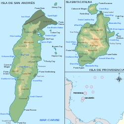
San Andrés and Providencia Department

Municipalities of San Andres and Providencia Islas de San Andres y Providencia.svg
Municipalities of San Andres and Providencia
  1. Providencia and Santa Catalina Islands
  2. San Andrés

Santander Department

Municipalities of Santander. Mapa de Santander (politico).svg
Municipalities of Santander.
  1. Aguada
  2. Albania
  3. Aratoca
  4. Barbosa
  5. Barichara
  6. Barrancabermeja
  7. Betulia
  8. Bolívar
  9. Bucaramanga
  10. Cabrera
  11. California
  12. Capitanejo
  13. Carcasí
  14. Cepitá
  15. Cerrito
  16. Charalá
  17. Charta
  18. Chima
  19. Chipatá
  20. Cimitarra
  21. Concepción
  22. Confines
  23. Contratación
  24. Coromoro
  25. Curití
  26. El Carmen
  27. El Guacamayo
  28. El Peñón
  29. El Playón
  30. Encino
  31. Enciso
  32. Florián
  33. Floridablanca
  34. Galán
  35. Gámbita
  36. Girón
  37. Guaca
  38. Guadalupe
  39. Guapotá
  40. Guavatá
  41. Güepsa
  42. Hato
  43. Jesus María
  44. Jordán
  45. La Belleza
  46. Landázuri
  47. La Paz
  48. Lebrija
  49. Los Santos
  50. Macaravita
  51. Málaga
  52. Matanza
  53. Mogotes
  54. Molagavita
  55. Ocamonte
  56. Oiba
  57. Onzaga
  58. Palmar
  59. Palmas Socorro
  60. Páramo
  61. Piedecuesta
  62. Pinchote
  63. Puente Nacional
  64. Puerto Parra
  65. Puerto Wilches
  66. Rionegro
  67. Sabana de Torres
  68. San Andrés
  69. San Benito
  70. San Gil
  71. San Joaquín
  72. San José de Miranda
  73. San Miguel
  74. Santa Bárbara
  75. Santa Helena del Opón
  76. San Vicente de Chucurí
  77. Simacota
  78. Socorro
  79. Suaita
  80. Sucre
  81. Surata
  82. Tona
  83. Valle de San José
  84. Vélez
  85. Vetas
  86. Villanueva
  87. Zapatoca

Sucre Department

Municipalities of Sucre. Mapa de Sucre (politico).svg
Municipalities of Sucre.
  1. Buenavista
  2. Caimito
  3. Chalán
  4. Colosó
  5. Corozal
  6. Coveñas
  7. El Roble
  8. Galeras
  9. Guaranda
  10. La Unión
  11. Los Palmitos
  12. Majagual
  13. Morroa
  14. Ovejas
  15. Palmito
  16. Sampués
  17. San Benito Abad
  18. San Juan Betulia
  19. San Marcos
  20. San Onofre
  21. San Pedro
  22. Sincé
  23. Sincelejo
  24. Sucre
  25. Tolú
  26. Toluviejo

Tolima Department

Municipalities of Tolima. Mapa de Tolima (politico).svg
Municipalities of Tolima.
  1. Alpujarra
  2. Alvarado
  3. Ambalema
  4. Anzoátegui
  5. Armero (Guayabal)
  6. Ataco
  7. Cajamarca
  8. Carmen Apicala
  9. Casabianca
  10. Chaparral
  11. Coello
  12. Coyaima
  13. Cunday
  14. Dolores
  15. Espinal
  16. Falán
  17. Flandes
  18. Fresno
  19. Guamo
  20. Herveo
  21. Honda
  22. Ibagué
  23. Icononzo
  24. Lérida
  25. Líbano
  26. Mariquita
  27. Melgar
  28. Murillo
  29. Natagaima
  30. Ortega
  31. Piedras
  32. Palocabildo
  33. Planadas
  34. Prado
  35. Purificación
  36. Rioblanco
  37. Roncesvalles
  38. Rovira
  39. Saldaña
  40. San Antonio
  41. San Luis
  42. Santa Isabel
  43. Suárez
  44. Valle de San Juan
  45. Venadillo
  46. Villahermosa
  47. Villarrica

Valle del Cauca Department

Municipalities of Valle del Cauca. Mapa de Valle del Cauca (politico).svg
Municipalities of Valle del Cauca.
  1. Alcalá
  2. Andalucía
  3. Ansermanuevo
  4. Argelia
  5. Bolívar
  6. Buenaventura
  7. Buga
  8. Bugalagrande
  9. Caicedonia
  10. Cali
  11. Calima
  12. Candelaria
  13. Cartago
  14. Dagua
  15. El Aguila
  16. El Cairo
  17. El Cerrito
  18. El Dovio
  19. Florida
  20. Ginebra
  21. Guacarí
  22. Jamundí
  23. La Cumbre
  24. La Unión
  25. La Victoria
  26. Obando
  27. Palmira
  28. Pradera
  29. Restrepo
  30. Riofrío
  31. Roldanillo
  32. San Pedro
  33. Sevilla
  34. Toro
  35. Trujillo
  36. Tuluá
  37. Ulloa
  38. Versalles
  39. Vijes
  40. Yotoco
  41. Yumbo
  42. Zarzal

Vaupés Department

Municipalities of Vaupes. Mapa de Vaupes (politico).svg
Municipalities of Vaupés.
Municipalities
  1. Caruru
  2. Mitú
  3. Taraira
Department Corregimientos
  1. Pacoa
  2. Papunahua
  3. Yavarate
Municipal Corregimientos
  1. Acaricuara
  2. Villa Fátima

Vichada Department

Municipalities of Vichada. Mapa de Vichada (politico).svg
Municipalities of Vichada.
  1. Cumaribo (including the former department corregimientos of San José de Ocune and Santa Rita)
  2. La Primavera
  3. Puerto Carreño
  4. Santa Rosalía

Districts

See also

Related Research Articles

<span class="mw-page-title-main">Santander Department</span> Department of Colombia

Santander is a department of Colombia. Santander inherited the name of one of the nine original states of the United States of Colombia. It is located in the central northern part of the country, borders the Magdalena River to the east, Boyacá to the south and southeast, the Norte de Santander Department to the northeast, the Cesar Department to the north, the Bolivar and Antioquia Departments to the west. Its capital is the city of Bucaramanga.

<span class="mw-page-title-main">Cauca Department</span> Department of Colombia

Cauca Department is a department of Southwestern Colombia. Located in the southwestern part of the country, facing the Pacific Ocean to the west, the Valle del Cauca Department to the north, Tolima Department to the northeast, Huila Department to the east, and Nariño Department to the south. Putumayo and Caqueta Departments border the southeast portion of Cauca Department as well. It covers a total area of 29,308 km2 (11,316 sq mi), the 13th largest in Colombia. Its capital is the city of Popayán. The offshore island of Malpelo belongs to the department. It is located in the southwest of the country, mainly in the Andean and Pacific regions plus a tiny part (Piamonte) in the Amazonian region. The area makes up 2.56% of the country.

<span class="mw-page-title-main">Chocó Department</span> Department of Colombia

Chocó Department is a department of the Pacific region of Colombia known for hosting the largest Afro-Colombian population in the nation, and a large population of Amerindian and mixed African-Amerindian Colombians. It is in the west of the country, and is the only Colombian department to have coastlines on both the Pacific Ocean and the Atlantic Ocean. It contains all of Colombia's border with Panama. Its capital is Quibdó.

<span class="mw-page-title-main">Cúcuta</span> Municipality of Colombia in North Santander

Cúcuta, officially San José de Cúcuta, is a Colombian municipality, capital of the department of Norte de Santander and nucleus of the Metropolitan Area of Cúcuta. The city is located in the homonymous valley, at the foot of the Eastern Ranges of the Colombian Andes, on the border with Venezuela. It comprises an area of approximately 1119 km2, with an urban area of 64 km2 and a rural area of 1055 km2. The city has a population of 777,106 inhabitants, which makes it the most populous municipality in the department and the sixth most populous municipality in the country. Similarly, its metropolitan area has an approximate population of 1,046,347.

Cerro is Spanish for "hill" or "mountain".

El Carmen may refer to:

<span class="mw-page-title-main">Liborina</span> Municipality and town in Antioquia Department, Colombia

Liborina is a municipality in Colombia, located in the Western subregion of the Antioquia Department. It borders the municipalities of Sabanalarga, San Andrés de Cuerquia, and San José de la Montaña to the north; San José de la Montaña and Belmira to the east; Santa Fe de Antioquia and Olaya to the south; and Buriticá to the west. Its town center is 80 kilometers via Sopetrán and 77 kilometers via Santa Fe de Antioquia from Medellín, the capital of Antioquia. The municipality covers an area of 217 square kilometers and is connected by road to the municipalities of Sabanalarga, San José de la Montaña, Belmira, Olaya, and Buriticá.

<span class="mw-page-title-main">Montebello, Antioquia</span> Municipality and town in Antioquia Department, Colombia

Montebello is a town and municipality in Antioquia Department, Colombia. Located at an elevation of 2,350 m above sea level, it is part of the sub-region of Southwestern Antioquia. It borders the municipality of El Retiro to the north, Fredonia and Santa Bárbara to the west, Abejorral to the south, and La Ceja and El Retiro to the east.

<span class="mw-page-title-main">Municipalities of Venezuela</span> Subdivisions of the States of Venezuela

Municipalities of Venezuela are subdivisions of the States of Venezuela. There are 335 municipalities dividing the 23 states and the Capital District.

<span class="mw-page-title-main">San Juan del Cesar</span> Municipality and town in Caribbean, Colombia

San Juan del Cesar is a municipality and town located in the La Guajira Department, Colombia.

<span class="mw-page-title-main">Piamonte</span> Municipality and town in Cauca Department, Colombia

Piamonte is a town and municipality in the Cauca Department, Colombia.

<span class="mw-page-title-main">Aguachica</span> Municipality and city in Caribbean, Colombia

Aguachica, is a city and municipality in the southern region of the Cesar Department, Colombia, located between the inter-Andean valley of Magdalena Medio and the Motilones. It is the second most populated municipality in the department and an important livestock and commercial center in the southeast of the Colombian Caribbean.

<span class="mw-page-title-main">Municipalities of Bolivia</span>

Municipalities in Bolivia are administrative divisions of the entire national territory governed by local elections. Municipalities are the third level of administrative divisions, below departments and provinces. Some of the provinces consist of only one municipality. In these cases the municipalities are identical to the provinces they belong to. There are 340 municipalities.

<span class="mw-page-title-main">Consaca</span> Municipality and town in Nariño Department, Colombia

Consaca is a town and municipality in the Nariño Department, Colombia. It is a town and municipality of Nariño Colombia, and has 12.639 inhabitants. Consaca is located near the Galeras Volcano and is 54 Kilometers away by car from the city San Juan de Pasto. Consaca is known by the name "Historical corner of Colombia".

<span class="mw-page-title-main">Argelia, Cauca</span> Municipality and town in Cauca Department, Colombia

Argelia is a town and municipality in the Cauca Department, Colombia. Founded by Order No. 02 on November 3, 1967, the municipality covers an area of 713 km2 and has a population of around 20,000. The population is primarily engaged in agriculture.

San Jose Villa de Allende is a town and municipal seat of the municipality of Villa de Allende. It is the fifth largest town in the municipality. It is located 70 kilometers to the west of the city of Toluca. Villa de Allende was named in honor of Ignacio Allende, a hero of the Mexican War of Independence.

<span class="mw-page-title-main">Caribbean Terrane</span> Geological province of Colombia

The Caribbean Terrane is a geological province (terrane) of Colombia. The terrane, dating to the Late Cretaceous, is situated on the North Andes Plate and borders the La Guajira, Chibcha and underlying Tahamí Terrane along the regional Bucaramanga-Santa Marta Fault. The terrane overlies the Tahamí, Arquía and Quebradagrande Terranes along the Romeral Fault System.

References

  1. "Nuestra Entidad - FCM" (in Spanish). Archived from the original on 29 September 2007.
  2. Article 7 http://www.alcaldiabogota.gov.co/sisjur/normas/Norma1.jsp?i=48267