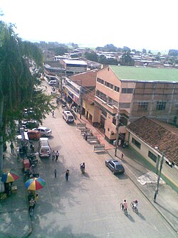
Cartago is a city in southwestern Colombia, about 187 miles (301 km) west of Bogotá. It is in the extreme northern portion of the Valle del Cauca Department. It is located very close to the city of Pereira, about a 20-minute drive. It is the sixth largest city in Valle after Cali, Palmira, Buenaventura, Tuluá and Jamundí. Per the 2018 Colombian census, Cartago's population was 118,803, a decrease from 121,741 per the Censo de Colombia de 2005.

Santiago de Cali, or Cali, is the capital of the Valle del Cauca department, and the most populous city in southwest Colombia, with 2,227,642 residents according to the 2018 census. The city spans 560.3 km2 (216.3 sq mi) with 120.9 km2 (46.7 sq mi) of urban area, making Cali the second-largest city in the country by area and the third most populous after Bogota and Medellin. As the only major Colombian city with access to the Pacific Coast, Cali is the main urban and economic center in the south of the country, and has one of Colombia's fastest-growing economies. The city was founded on 25 July 1536 by the Spanish explorer Sebastian Belalcazar.
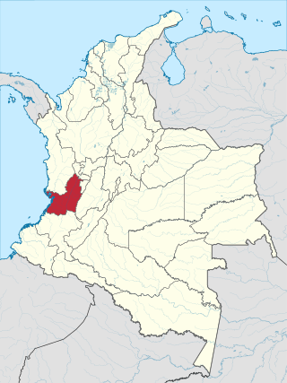
Valle del Cauca, or Cauca Valley, is a department in western Colombia abutting the Pacific Ocean. Its capital is Santiago de Cali. Other cities such as Buenaventura, Buga, Cartago, Palmira and Tuluá have great economical, political, social and cultural influence on the department's life. Valle del Cauca has the largest number of independent towns with over 100,000 inhabitants in the country, counting six within its borders. Buenaventura has the largest and busiest seaport in Colombia, moving about 8,500,000 tons of merchandise annually.

Alfonso Bonilla Aragón International Airport, formerly known as Palmaseca International Airport, is an international airport located between Palmira and Cali, the capital of Valle del Cauca Department, Colombia. It is Colombia's fourth-busiest airport in passenger volume, with 5,600,000 people using the airport in 2016, and the third largest in area and construction. The airport often serves as the alternate airport for Bogotá - El Dorado Int'l Airport and other Colombian airports.

Ibagué is the capital of Tolima, one of the 32 departments that make up the Republic of Colombia. The city is located in the center of the country, on the central mountain range of the Colombian Andes, near Nevado del Tolima. It is one of the most populous cities in the country, with a population of 492,554, making it the eleventh most populous in Colombia, and with a population of 529,625 in the municipality. It was founded on October 14, 1550, by the Spanish captain Andrés López de Galarza. The city of Ibagué is divided into 13 communes and the rural area has 17 corregimientos. As the capital of the department of Tolima the city hosts the Government of Tolima, the Departmental Assembly, and the Attorney General's Office. It is the main epicenter of political, economic, administrative, business, art, culture, and tourism activities in the area.

Palmira is a city and municipality in southwestern Colombia in the Valle del Cauca Department, located about 27 kilometres (17 mi) east from Cali, the department's capital and main city in the South of Colombia. Palmira is the second largest city in the Valle del Cauca, behind Cali.
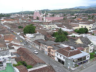
Buga, formally Guadalajara de Buga, is a city and municipality in the Valle del Cauca Department of Colombia. It is famous for its Basilica del Señor de los Milagros, which houses an image of Christ called el Señor de los Milagros.
The Western Bloc of the Revolutionary Armed Forces of Colombia was the smallest of the Revolutionary Armed Forces of Colombia's (FARC) blocs in size, although not in military capability. It was often held responsible for attacks that occurred in Cali and the surrounding area. The specific divisions of the group are arguable. Some of its divisions or fronts, as they were commonly known as, are shown below. Many of these fronts worked together at times towards a certain mission, while others were further divided into columns and companies with a smaller number of members. For more general information, see FARC-EP Chain of Command.

El Cerrito is a town and municipality located in the Department of Valle del Cauca, Colombia. This is one of the 42 municipalities of the department.
Jamundí is a city and municipality in the Department of Valle del Cauca, Colombia.

Francisco Hélmer Herrera Buitrago also known as "Pacho" and "H7", was a Colombian drug trafficker, fourth in command in the Cali Cartel, and believed to be the son of Benjamín Herrera Zuleta.
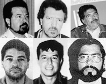
Phanor Arizabaleta-Arzayus was a Colombian drug trafficker. He was a member of the Cali Cartel and the fifth most important in the chain of command.

The Valle del Cauca Deputies hostage crisis refers to the kidnapping of 12 Deputies of the Assembly of Valle del Cauca, Colombia, on April 12, 2002 by members of the Revolutionary Armed Forces of Colombia (FARC) to pressure a prisoner exchange between them and the government and to negotiate the demilitarization of the municipalities of Florida and Pradera to initiate peace dialogues.

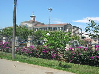
The University of Valle, also called Univalle, is a public, departmental, coeducational, research university based primarily in the city of Cali, Valle del Cauca, Colombia. It is the largest higher education institution by student population in the southwest of the country, and the third in Colombia, with more than 30,000 students. The university was established by ordinance No. 12 of 1945, by the Departmental Assembly as the Industrial University of Valle del Cauca, under the leadership of Tulio Ramírez Rojas and Severo Reyes Gamboa.
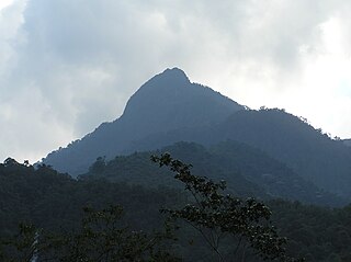
Farallones de Cali is a cluster of mountains in the West Andes of Colombia. It is located west of the city of Cali and gives rise to many of the rivers that provide water and electricity to Cali. The PNN Farallones de Cali encompasses 150,000 ha (580 sq mi) in the mountains as well as much of the Pacific slope and is an area of very high biodiversity. The average temperature ranges from 25 °C (77 °F) in the tropical foothills to 5 °C (41 °F) in the páramo. In this territory are located the district of Pichinde, Andes and Leonera, and two villages Penas Blancas and Lomas de la Cajita.
El Queremal is a town in the Dagua municipality, Valle del Cauca Department, Colombia. It is located about 47 km (29 mi) west of Cali and is at an elevation of 1,450 m (4,760 ft). The town is situated on the upper part of the Old Cali-Buenaventura Road and is about 99 km (62 mi) from Buenaventura, the main Colombian port on the Pacific. The town is accessible from Cali from several roads leading away from the main Cali-Buenaventura Road near the area of Kilometer 18, Valle del Cauca.
Guillermina Bravo Montaño is a Colombian teacher and politician of the Independent Movement of Absolute Renovation (MIRA) party. Currently she is a member of the Chamber of Representatives of Colombia. She was Deputy of the Department Assembly of Valle del Cauca from 2008 to 2011.
Orsomarso Sportivo Clube is a Colombian professional football team based in Palmira. Founded in 2012, the club currently competes in the Categoría Primera B, and plays its home games at the Francisco Rivera Escobar stadium. Its name comes from the Italian comune Orsomarso.
El Tiple is a village located in the municipality of Candelaria, department of Valle del Cauca in Colombia.