Valle del Cauca, or Cauca Valley, is a department in western Colombia abutting the Pacific Ocean. Its capital is Santiago de Cali. Other cities such as Buenaventura, Buga, Cartago, Palmira and Tuluá have great economical, political, social and cultural influence on the department's life. Valle del Cauca has the largest number of independent towns with over 100,000 inhabitants in the country, counting six within its borders. Buenaventura has the largest and busiest seaport in Colombia, moving about 8,500,000 tons of merchandise annually.

Puerto Boyacá is a Colombian river-port town and municipality by the Magdalena River in the Boyacá Department, where is also considered a Special Trade Zone due to its port status. Its main industries are oil exploration and processing. In the 1980s and early 1990s, Puerto Boyacá was affected intensively by the Colombian Armed Conflict.

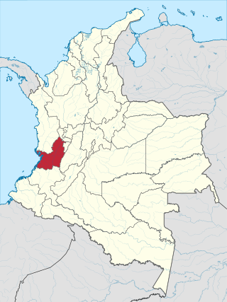
Zarzal is a city and municipality in the north of the department of Valle del Cauca in Colombia. Its economy is based primarily on the extensive cultivation of sugar cane, on small and medium enterprises in the metallurgic sector, and on utilities. Commerce is also of great importance, because a great number of warehouses for basic necessity goods exist in the city. A marketplace also exists, which serves as reference for various cities that are close by. Zarzal municipality has a population of about 42,000. New city districts were constructed in the center of the city; it has now become difficult to find bare land inside the city.

Cajamarca is a town and municipality in the Tolima Department of Colombia. The population of the municipality was 17,309 as of the 2018 census. The municipality has two populated centres, the town centre of Cajamarca and the locality of Anaime. It is located along the Pan-American Highway.

Arboletes is a town and municipality in the subregion of Urabá in Antioquia Department, Colombia.

Necoclí is a town and municipality in Antioquia Department, Colombia. Located on the eastern shore of the Gulf of Urabá, it is part of the Urabá Antioquia sub-region. The population is predominantly Afro-Colombian.
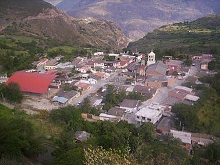
Tipacoque is a municipality and town in Boyacá Department, Colombia, located on the Altiplano Cundiboyacense, part of the Eastern Ranges of the Colombian Andes. Tipacoque is situated on the western flank of the Chicamocha river canyon. It is part of the Northern Boyacá Province.
Rodolfo Abularach was a Guatemalan painter and printmaker of Palestinian descent.

Pueblo Bello, is a village and municipality in the northern region of the Department of Cesar, Colombia. It is located in the mountains of the Sierra Nevada de Santa Marta and is home to Amerindians pertaining to the Arhuaco ethnicity, whom consider Pueblo Bello a sanctuary but by the name of Arumake in their language. Pueblo Bello is the main producer of coffee in the Caribbean Region of Colombia.

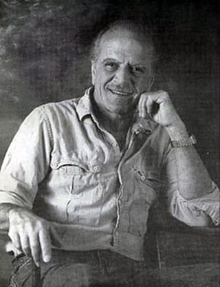
Omar Rayo Reyes was a renowned Colombian painter, sculptor, caricaturist and plastic artist. He won the 1970 Salón de Artistas Colombianos. Rayo worked with abstract geometry primarily employing black, white, red and yellow. He was part of the Op Art movement. Rayo's work shows that geometric art is as much a part of the past as it is of the future. He used traces of the past to discover new ways to present visual and geometric sketches.
Bagadó is a municipality and town in the Chocó Department, Colombia.

El Cocuy is a town and municipality in the Colombian Department of Boyacá, part of the sub-region of the Gutiérrez Province. The national natural park El Cocuy National Park is nearby.
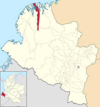
La Tola is a town and municipality in the Nariño Department, Colombia.

Caloto is a town and municipality in the Cauca Department, Colombia. It was founded on June 29, 1543 by Sebastián de Belalcázar.
Puerto Tejada is a town and municipality in the Cauca Department, Colombia.

Puracé is a town and municipality in the Cauca Department, Colombia.

El Cairo is a town and municipality located in the Department of Valle del Cauca, Colombia.

El Dovio is a town and municipality located in the Department of Valle del Cauca, Colombia.
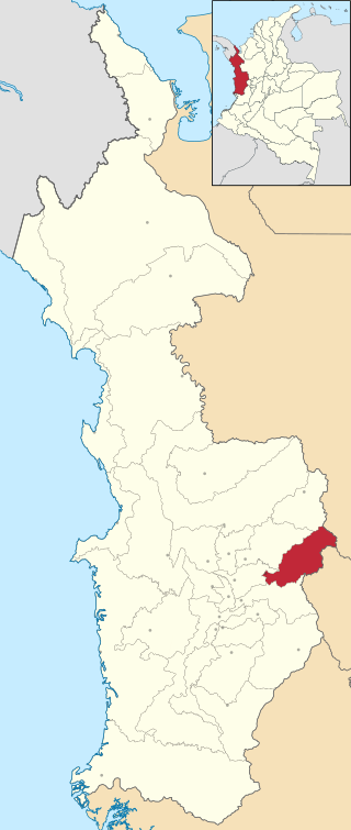
Pradera is a town and municipality in the Department of Valle del Cauca, Colombia.

Versalles is a town and municipality located in the Department of Valle del Cauca, Colombia.