Magdalena is a department of Colombia, located to the north of the country by the Caribbean Sea. The capital of the Magdalena Department is Santa Marta and was named after the Magdalena River. It inherited the name of one of the original nine states of the United States of Colombia that its current territory integrated.

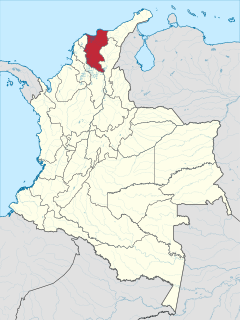
Cesar Department or simply Cesar is a department of Colombia located in the north of the country in the Caribbean region, bordering to the north with the Department of La Guajira, to the west with the Department of Magdalena and Department of Bolivar, to the south with Department of Santander, to the west with the Department of North Santander, and to the east with the country of Venezuela. The department capital city is Valledupar.
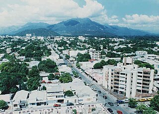
Valledupar is a city and municipality in northeastern Colombia. It is the capital of Cesar Department. Its name, Valle de Upar, was established in honor of the Amerindian cacique who ruled the valley; Cacique Upar. The city lies between the mountains of Sierra Nevada de Santa Marta and the Serranía del Perijá to the borders of the Guatapurí and Cesar rivers.

The Municipalities of Colombia are decentralized subdivisions of the Republic of Colombia. Municipalities make up most of the departments of Colombia with 1,122 municipalities (municipios). Each one of them is led by a mayor (alcalde) elected by popular vote and represents the maximum executive government official at a municipality level under the mandate of the governor of their department which is a representative of all municipalities in the department; municipalities are grouped to form departments.
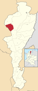
El Paso is a municipality in the Cesar Department of Colombia. El Paso is mostly known for having the second largest coal mine in Colombia, located in the corregimiento of La Loma.

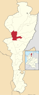
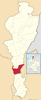
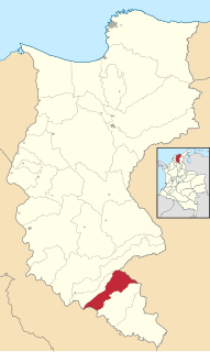
Los Robles La Paz or simply La Paz is a municipality and a town in the Department of Cesar, Colombia. The town is close to the Capital city of the Department of Cesar; Valledupar. The municipality of La Paz borders to the north with La Guajira Department, to the northeast with the municipality of Manaure. To the east with the Bolivarian Republic of Venezuela sharing the Serranía del Perijá mountain range. To the south with the municipality of Codazzi, southwest with the municipality of El Paso, Cesar. To the west with the municipality of San Diego and to the northwest with the municipality of Valledupar.
La Gloria is a municipality and town in the Department of Cesar, northern Colombia by the Magdalena River.
Pueblo Bello, is a village and municipality in the northern region of the Department of Cesar, Colombia. It is located in the mountains of the Sierra Nevada de Santa Marta and is home to Amerindians pertaining to the Arhuaco ethnicity, whom consider Pueblo Bello a sanctuary but by the name of Arumake in their language. Pueblo Bello is the main producer of coffee in the Caribbean Region of Colombia.

Aguachica, is a small city and municipality in the southern region of the Cesar Department, Colombia. It was officially founded on August 16, 1748, by José Lázaro de Rivera.

Chimichagua is a city and municipality in the central region of the Department of Cesar, Colombia. Approximately one third of the municipality of Chimichagua is water. The municipality seat lies by the Cienaga de Zapatosa marshes.
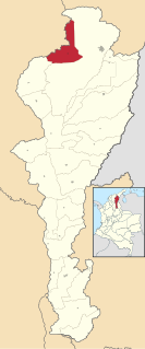
Becerril or Becerril de Campos is a town and municipality of the Colombian Department of Cesar.
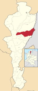
Bosconia is a town and municipality in the Colombian Department of Cesar.

Tamalameque is a town and municipality in the Colombian Department of Cesar. It was originally the site of a Chimila settlement, Thamara. Tamalameque is located on the right bank of the Magdalena River and borders Chimichagua and Pailitas in the north, Pelaya in the east, La Gloria in the south and in the west the departments of Bolívar and Magdalena.
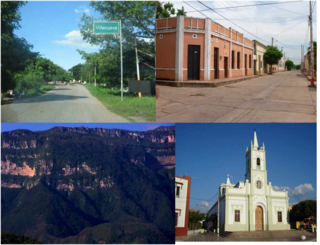
Villanueva is a town and municipality located in the northern Department of La Guajira, Colombia. Villanueva is known in Colombia for being the cradle of many vallenato singers and composers. The economy of the town relies heavily on agriculture and farming.

El Piñón is a town and municipality of the Colombian Department of Magdalena. Officially founded in 1760 by Francisco Sayas, Ignacio Crespo, Vicente De la Hoz and others. On April 20, 1915 was proclaimed a municipality. Its economy is based on agriculture and farming. Its main tourist attraction is the Iglesia San Pedro Mártir and the Ave Maria Monument. The town celebrates carnivals, the Saint Peter of Verona Day in April, El Milagroso in September, the Unedited Song Festival and the Decimates Festival.

Pedraza is a town and municipality of the Colombian Department of Magdalena.

Sabanas de San Ángel, Spanish for Savannas of Saint Angel, is a town and municipality of the Colombian Department of Magdalena. Founded around 1607 with the name San Antoñito by the Spanish Colonizers as a pathway town in the route between La Guajira Department and the Magdalena River. On June 24, 1999 the municipality is created with the name of Sabanas de San Angel that segregated from the municipalities of Ariguaní, Pivijay, Chibolo and Plato.
San Sebastián de Buenavista is a town and municipality of the Colombian Department of Magdalena. Founded in 1748 by Fernando de Mier y Guerra with the name San Sebastián de Melchiquejo, but was later changed on November 15, 1957 when it was erected municipality.

Santa Ana is a town and municipality of the Magdalena Department in northern Colombia. Founded in 1751 by José Fernando de Mier y Guerra with the name of Santa Ana de Buena Vista. In 1918 was established as a municipality.
Ciénaga de Zapatosa is a large marsh in a depression located between the Colombian departments of Cesar and Magdalena covering an area of approximately 40,000 ha and containing one million cubic meters of water.