
Cesar Department or simply Cesar is a department of Colombia located in the north of the country in the Caribbean region, bordering to the north with the Department of La Guajira, to the west with the Department of Magdalena and Department of Bolivar, to the south with Department of Santander, to the west with the Department of North Santander, and to the east with the country of Venezuela. The department capital city is Valledupar.
Mohra Sharif is a spiritual center and home of the Sufi order is a Naqshbandi in origin, and is based in a small village called Mohra Sharif located in the Murree Hills of Punjab, near the Pakistani capital of Islamabad. It was made into a spiritual center by Baba Ji Khawaja Muhammad Qasim Sadiq, a purported Sufi shaikh of this area.
Islam Pura is a neighbourhood in District South of Karachi, Pakistan.
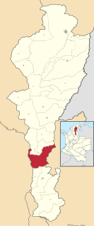
La Gloria is a municipality and town in the Department of Cesar, northern Colombia by the Magdalena River.

Fuentelespino de Haro is a municipality in Cuenca, Castile-La Mancha, Spain. It has a population of 311.

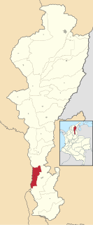
Chimichagua is a city and municipality in the central region of the Department of Cesar, Colombia. Approximately one third of the municipality of Chimichagua is water. The municipality seat lies by the Cienaga de Zapatosa marshes.
Gamarra is a town and municipality in the Colombian Department of Cesar.

González is a town and municipality in the Colombian Department of Cesar.

Pailitas is a town and municipality in the Colombian Department of Cesar.

Río de Oro is a town and municipality in the Colombian Department of Cesar.

San Martín is a town and municipality in the Colombian Department of Cesar.

Tamalameque is a town and municipality in the Colombian Department of Cesar. It was originally the site of a Chimila settlement, Thamara. Tamalameque is located on the right bank of the Magdalena River and borders Chimichagua and Pailitas in the north, Pelaya in the east, La Gloria in the south and in the west the departments of Bolívar and Magdalena.

Regidor is a town and municipality located in the Bolívar Department, northern Colombia in a lowland area along the banks of the Magdalena River. The principal industry of Regidor is cultivation of Oil Palm. Many subsistence farmers have been pressured to sell their land to oil palm companies and to displace.
Pauna is a town and municipality in the Colombian Department of Boyacá, part of the subregion of the Western Boyacá Province.
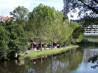
Vouga River is a river in the Centro Region of Portugal. The source of the Vouga is the Chafariz da Lapa, at an elevation of 864 metres (2,835 ft), in the parish of Quintela, municipality of Sernancelhe, Viseu District. The course of the river ends in the Atlantic Ocean, in the form of a ria, the Ria de Aveiro.
Jasa is a municipality located in the province of Huesca, Aragon, Spain. According to the 2004 census (INE), the municipality has a population of 128 inhabitants.

Patillal is a village and corregimiento in the municipality of Valledupar within the Colombian Department of Cesar. The town lies on the steps of the Sierra Nevada de Santa Marta with a semiarid terrain.

Araripina is a Brazilian municipality in the state of Pernambuco. Has an estimated population in 2009 of 79.877 inhabitants according with IBGE. Total area of 1.847,5 km2 and is located in the state mesoregion of Sertão, at 622 meters above the sea level and 683 km West from the state capital, Recife. The exploration of gypsum and calcarium is the base of the local economy and at the homonymous microregion.

Korytków Duży is a village in the administrative district of Gmina Biłgoraj, within Biłgoraj County, Lublin Voivodeship, in eastern Poland. It lies approximately 8 kilometres (5 mi) north-west of Biłgoraj and 73 km (45 mi) south of the regional capital Lublin.
Bajarwala is a small village of Gujrat District in the province of Punjab, Pakistan. Bajarwala is located near the town of Dinga and its latitude and longitude is 32°65'31N, 73°68'27E. Bajarwala is about 140 km from the capital city of Islamabad.

