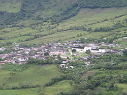
The town of Santa Rosa had several foundations. The first settlement was entrusted by the Spanish crown to Antonio Gonzalez who then delegated it to Bernardino Mujica.[2] In June 26, 1593, Captain Bernardo de Vargas Machuca, a Spaniard from the city of Simancas reported having reached the settlement on the side of the Iscansé river. He then named the town Simancas in the memory of his home town.[3] The Iscansé river that Vargas Machuca mentions is the upper course of today's Caquetá river. In the year 1600, the Andakies and Aguanungas, indigenous tribes from these region, rebelled and destroyed the towns of Mocoa and Simancas.
In order to protect the memory of the town, a commemorative plate was placed by the local community on the walls of the Church of Santa Rosa in the center of the town that reads:
"ESTE LUGAR FUE SEDE DE UNA DE LAS FUNDACIONES DE SIMANCAS, ACTUALMENTE SANTAROSA: 1551, 1595,1685,1871,1907 TESTIMONIO DE ALCIDES JIMENEZ, RODRIGO BOTINA Y MARIO MEJIA - SANTA ROSA 1991"
Translation:
"This place is one of the foundational sites of Simancas, Currently Santarosa:1551, 1595,1685, 1871,1907 Testimony of Alcides JImenez, Rodrigo Botina & Mario Mejia - Santa Rosa 1991
The most recent foundation of Santa Rosa is attributed to Eduwiges Becerra and Benito Mavesoy who allegedly donated the land in year 1870. After August 30, 1872, Leonidas Gómez from Almaguer, Quina's agent, changed the name of Villa or Town of Simancas to Santa Rosa. However, there is no consensus among historians about the details of the foundation events. Some historians claim that the land for the foundation was donated to the Catholic Church in July 17, 1898.[4]
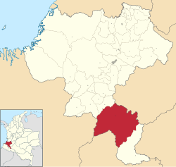
Demographics
The municipality of Santa Rosa presented a -4.4% annual population growth between 2005 and 2018
↑ Vargas Machuca, Bernardo (1599). Milicia y descripción de las Indias, por el capitan don Bernardo de Vargas Machuca (p82). n.p.: Casa de Pedro Madrigal.
This page is based on this Wikipedia article Text is available under the CC BY-SA 4.0 license; additional terms may apply. Images, videos and audio are available under their respective licenses.