The Republic of Colombia is a transcontinental country largely situated in the northwest of South America, with territories in North America. Colombia is bordered to the northwest by Panama; to the east by Venezuela and Brazil; to the south by Ecuador and Peru; and it shares maritime limits with Costa Rica, Nicaragua, Honduras, Jamaica, the Dominican Republic, and Haiti. Colombia is the 26th largest nation in the world and the fourth-largest country in South America after Brazil, Argentina, and Peru. Despite its large territory, Colombia's population is not evenly distributed, with most Colombians living in the mountainous western portion of the country as well as the northern coastline, most living in or near the capital city of Bogotá. The southern and eastern portions of the country are mostly sparsely inhabited tropical rainforest, and inland tropical plains containing large estates or large livestock farms, oil and gas production facilities, small farming communities and indigenous tribes.

Cauca Department is a Department of Colombia. Located in the southwestern part of the country, facing the Pacific Ocean to the west, the Valle del Cauca Department to the north, Tolima Department to the northeast, Huila Department to the east, and Nariño Department to the south. Putumayo and Caqueta Departments border the southeast portion of Cauca Department as well. It covers a total area of 29,308 km2 (11,316 sq mi), the 13th largest in Colombia. Its capital is the city of Popayán. The offshore island of Malpelo belongs to the department. It is located in the southwest of the country on the Andean and Pacific regions. The area includes 2.56% of the country.

The Sierra Nevada de Santa Marta is an isolated mountain range separated from the Andes chain that runs through Colombia. Reaching an altitude of 5,700 m (18,700 ft) just 42 km (26 mi) from the Caribbean coast, the Sierra Nevada is one of the world's highest coastal ranges, being 250m shorter than the Saint Elias Mountains in Canada. The Sierra Nevada encompasses about 17,000 km2 (6,600 sq mi) and serves as the source of 36 rivers. The range is in the Departments of Magdalena, Cesar and La Guajira.

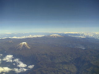
The Cordillera Central is the highest of the three branches of the Colombian Andes. The range extends from south to north dividing from the Colombian Massif in Cauca Department to the Serranía de San Lucas in Bolivar Departments. The highest peak is Nevado del Huila at 5,364 m (17,598 ft).

The Cordillera Occidental is the lowest in elevation of the three branches of the Colombian Andes. The average altitude is 2,000 m (6,600 ft) and the highest peak is Cerro Tatamá at 4,100 m (13,500 ft). The range extends from south to north dividing from the Colombian Massif in Nariño Department, passes north through Cauca, Valle del Cauca, Risaralda, Chocó, and Caldas Departments to the Paramillo Massif in Antioquia and Córdoba Departments. From this massif the range divides further to form the Serranías de Ayapel, San Jerónimo and Abibe. Only to recede into the Caribbean plain and the Sinú River valley.

The Cordillera Oriental is the widest of the three branches of the Colombian Andes. The range extends from south to north dividing from the Colombian Massif in Huila Department to Norte de Santander Department where it splits into the Serranía del Perijá and the Cordillera de Mérida in Venezuelan Andes. The highest peak is Ritacuba Blanco at 5,410 m (17,750 ft) in the Sierra Nevada del Cocuy.

The Andes region, located in the center of Colombia, is the most populated region of Colombia. With many mountains contains the majority of the country's urban centers. They were also the location of the most significant pre-Columbian indigenous settlements. Beyond the Colombian Massif in the south-western departments of Cauca and Nariño, the Colombian Andes divide into three branches known as "cordilleras" : the West Andes run adjacent to the Pacific coast and is home to the city of Cali. The Central Andes run up the center of the country between the Cauca and Magdalena river valleys and includes the cities of Medellín, Manizales and Pereira. The East Andes extend northeast towards the Guajira Peninsula, and includes the cities of Bogotá, Bucaramanga and Cúcuta.
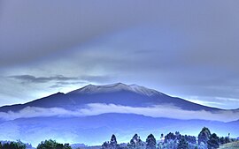
Los Nevados National Natural Park is a national park located in the Cordillera Central of the Colombian Andes. The park sourrounds the northern volcanic complex formed by Nevado del Ruiz, Nevado del Tolima, Nevado de Santa Isabel, the paramillos of Cisne, Santa Rosa and Quindío and the Cerro Bravo and Cerro Machín.
The rufous-fronted parakeet is a species of parrot in the family Psittacidae. Endemic to Colombia, its natural habitats are high-altitude shrubland, high-altitude grassland and arable land. It is threatened by habitat destruction and is classified as "vulnerable" by the International Union for Conservation of Nature.

Because of its natural structure, Colombia can be divided into six very distinct natural regions. These consist of the Andean Region, covering the three branches of the Andes mountains found in Colombia; the Caribbean Region, covering the area adjacent to the Caribbean Sea; the Pacific Region adjacent to the Pacific Ocean; the Orinoquía Region, part of the Llanos plains mainly in the Orinoco river basin along the border with Venezuela; the Amazon Region, part of the Amazon rainforest; and finally the Insular Region, comprising islands in both the Atlantic and Pacific oceans. Colombia is located in South America.

The Serranía del Pinche are part of the Western Ranges of the Colombian Andes. The mountains consist of several high peaks with small patches of isolated páramo and provide a corridor between the Pacific and Andean biogeographic regions. It is located municipality of Argelia in the Department of Cauca. This area is under consideration for protection as a Flora and Fauna Sanctuary by the Colombian government. This area is important for its incredible biodiversity and high percentage of primary forest. An endemic hummingbird - the gorgeted puffleg - is only found here and the population is considered to be critically endangered.
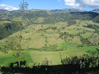
The Serranía de las Minas is a mountainous region in the Central Andes near Puracé National Natural Park in the Department of Huila of Colombia. This area gives rise to the waters of the Magdalena River. It is a proposed Flora and Fauna Sanctuary for the existence of primary montane forest and habitat for many important species of amphibians, mammals, and birds.
Farallones de Cali is a cluster of mountains in the West Andes of Colombia. It is located west of the city of Cali and gives rise to many of the rivers that provide water and electricity to Cali. The PNN Farallones de Cali encompasses 150,000 ha (580 sq mi) in the mountains as well as much of the Pacific slope and is an area of very high biodiversity.. The average temperature ranges from 25 °C (77 °F) in the tropical foothills to 5 °C (41 °F) in the páramo.
The Tamá National Natural Park is a national park located in the Tamá Massif of the Andean Region of Colombia, between the municipalities Toledo and Herrán, in the department of Norte de Santander, in the northeastern part of the Eastern Ranges of the Colombian Andes. One of the main attractions of the park is a 820-metre-high (2,690 ft) waterfall, one of the world's highest.
The Puracé National Natural Park is a national park located in the Andean Region of Colombia, southeast of the city of Popayán in the Cordillera Central range. Its main feature is the active stratovolcano Puracé, one of Colombia's most active volcanoes. Four of the country's most important rivers originate within the area: Magdalena River, Cauca River, Japurá River and Patía River.
The Paramillo Massif is a mountain range of the Tropical Andes System, located at the northern end of the Cordillera Occidental range in Colombia.

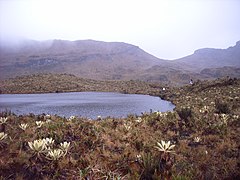
The Northern Andean páramo (NT1006) is an ecoregion containing páramo vegetation above the treeline in the Andes of Colombia and Ecuador. In the past, when the climate was cooler, the treeline and the páramo units were lower and the units were connected. During the present warmer Holocene epoch the páramos have migrated uphill, shrinking and becoming isolated. They contain many rare or endangered species, some of them restricted to a narrow area of one mountain or mountain range. The ecoregion is relatively well preserved, but faces threats from over-grazing and farming.

The Tamá Massif is a group of mountains on the border between Colombia and Venezuela to the south of Lake Maracaibo. It contains evergreen rainforest and cloud forest at the lower levels, and páramos at the highest levels.

The Cordillera Oriental montane forests (NT0118) is an ecoregion in Venezuela and Colombia along the east slopes of the eastern cordillera of the Andes. The extensive region of submontane and montane forests includes distinctive flora and fauna in the north, center and southern sections. The ecoregion is home to numerous endemic species of fauna. Despite extensive changes due to logging, farming and ranching, large areas of the original habitat remain intact, and the ecoregion has rich biodiversity.

The Táchira depression is a saddle of land connecting the Lake Maracaibo basin to the Orinoco basin in the state of Táchira, Venezuela. It forms a break in the eastern Andes, separating the Tamá Massif to the west from the Cordillera de Mérida to the east. The depression has been thought to present a barrier to the movement of species between the Colombian and Venezuelan Andes, but this effect may have been relatively low during the recent ice ages. The mountains of the region have potential for coffee farming and hydroelectric power generation, while the lower levels are suitable for farming.