
Northwest College is a public community college in Powell, Wyoming.
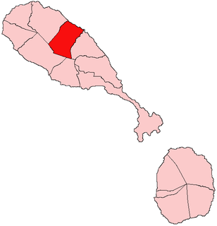
Christ Church Nichola Town is one of 14 administrative parishes that make up Saint Kitts and Nevis. The fifth largest parish on Saint Kitts, it is located on the east coast of the main island of Saint Kitts. The parish capital is Nichola Town and its largest town is Molyneux.

Windhill and Wrose is a ward within the City of Bradford Metropolitan District Council in the county of West Yorkshire, England, named after the districts of Windhill and Wrose around which it is drawn.

Monreal del Llano is a municipality in located in the province of Cuenca, Castile-La Mancha, Spain. It has a population of 74 (2014).

CFGP-FM is a Canadian radio station in Grande Prairie, Alberta. Owned by Rogers Media, it broadcasts an active rock format.
The Elk Valley Rancheria is a rancheria and federally recognized tribe of Tolowa and Yurok people. It is located in the CDP of Bertsch-Oceanview, Del Norte County, California, just east of Crescent City. As of the 2010 Census the population was 99.

Cedar Point is an unincorporated community in Union Township, White County, in the U.S. state of Indiana.

Pacific is a small unincorporated community in El Dorado County, California. It is located 3.25 miles (5 km) east of Pollock Pines, at an elevation of 3396 feet. It lies along U.S. Highway 50. The ZIP code is 95726. The community is inside area code 530.

Fresh Pond is a small unincorporated community in El Dorado County, California. It is located 3 miles (4.8 km) east of Pollock Pines, at an elevation of 3606 feet. The ZIP code is 95726. The community is inside area code 530. It is nestled along Highway 50 and offers a convenient gas station by the road.
High Woods is an unincorporated community in Accomack County, Virginia.
Léogâne is an arrondissement in the Ouest Department of Haiti. As of 2015, the population was 509,280 inhabitants. Postal codes in the Léogâne Arrondissement start with the number 62.

Beaver Lake is a hamlet in northern Alberta, Canada within Lac La Biche County. It is located on the shore of Beaver Lake, 4 kilometres (2.5 mi) east of Highway 55, approximately 116 kilometres (72 mi) northwest of Cold Lake.
Sidi Hassine is a town and commune in the Tunis Governorate, Tunisia. As of 2004 it had a population of 79,331.
Wesson is an unincorporated community located in Brunswick County, in the U.S. state of Virginia.
Radley is an unincorporated community in Crawford County, Kansas, in the United States.
South Radley is an unincorporated community in Crawford County, Kansas, in the United States.
Gayville is an unincorporated community in Lawrence County, in the U.S. state of South Dakota.
Kinzer is an unincorporated community in Butler County, in the U.S. state of Missouri.
Nella is an unincorporated community in Scott County, in the U.S. state of Arkansas.
Axemann is an unincorporated community in Centre County, in the U.S. state of Pennsylvania.


