Teusaquillo

Last updated • 8 min readFrom Wikipedia, The Free Encyclopedia
Teusaquillo
Bogota - Teusaquillo.svg
Location of the locality in the city of Bogotá
Distrito Capital de Bogota - Teusaquillo.svg
Location of the locality in the Capital District of Bogotá
Coordinates: 4°40′14″N74°05′35″W / 4.67056°N 74.09306°W / 4.67056; -74.09306
CountryFlag of Colombia.svg  Colombia
CityBogotá D.C.
Neighbourhoods
Area
  Total14.19 km2 (5.48 sq mi)
Elevation
2,600 m (8,500 ft)
Population
 (2007) [1]
  Total139,298
  Density9,800/km2 (25,000/sq mi)
Time zone UTC-5 (Colombia Standard Time)
Website Official website

Teusaquillo is the 13th locality of Bogotá, capital of Colombia. It is located in the geographic center of the city, to the northwest of downtown Bogotá. This district is inhabited by middle and upper class residents. It is an urbanized locality with several green zones as parks, avenues, and the campus of the National University of Colombia. Most of the heritage buildings and houses of Bogotá are in this locality. It is located on the former site of an indigenous resguardo known as Pueblo Viejo (Old Village), which existed until the main urbanization phase of the 20th century.

Contents

General information

Area

The total area of the locality is 14.19 square kilometres (5.48 sq mi), making the locality 11th of the 20 localities in terms of surface area.

Borders

Hydrology

Canal Arzobispo Canal del Arzobispo bogota Teusaquillo.JPG
Canal Arzobispo

The locality is located in the Salitre and Fucha River basins. The Simón Bolívar park also includes several lakes. Teusaquillo is crossed by various canals, which form part of the rainwater management system of Bogotá. They are extensions of streams that are sourced by the Eastern Hills.

Salitre River Basin
Fucha River Basin

Topography

Teusaquillo is relatively flat due to its location on the Bogotá savanna. It slopes slightly to the northwest.

History

Pre-Columbian, colonial, and post-colonial periods

Lake in the Simon Bolivar Park Bogota Lago Simon Bolivar.JPG
Lake in the Simón Bolívar Park

The name Teusaquillo, like the name of Bogotá itself, dates to pre-Columbian times. Similar to the city, the name corresponded to a different location that is located near the present-day municipality of Funza. That, in turn, was known as Bacatá and was the main settlement of the southern Muisca Confederation. Within the zipazgo was Teivzaquillo, Thibzaquivo, Teusacá or Tipizaquillo, the place of rest of the zipa; the leader of the Muisca in Bacatá. Teusacá in Muysccubun means "borrowed enclosure".

Located in the foothills of the Eastern Ranges of the Colombian Andes, the Bogotá savanna was discovered by conquistador Gonzalo Jiménez de Quesada. It was conquered by the Spanish who founded the town of Santafé de Bogotá on August 6, 1538, located in present-day La Candelaria. as the capital of the New Kingdom of Granada. At that time, the name Teivzaquillo fell out of use.

During the post-colonial period, the locality remained a rural area with a largely agrarian economy. It was known as Pueblo Viejo.

Modern times

House in Teusaquillo Casa carrera 16 clle 28A.JPG
House in Teusaquillo

On September 7, 1902, Football Club opened the city's first football field in the Pueblo Viejo area and named it Teusaquillo, a Spanish translation of Teivzaquillo, as an homage to the indigenous Muisca who had lived in the area. That field saw the first game between Colombian football teams, the Red Team and the White Team, both belonging to Football Club. The following year, another field was built and named Marly. The area quickly became the capital city's football destination.

It was not until the 1920s that large-scale urbanization took place north of the Santa Fe neighborhood. As neighborhoods were constructed between Santa Fe and the still-small village of Chapinero, it was decided the area should be named Teusaquilo. The naming occurred in 1927 and the neighborhood quickly became one of the more modern and elegant of the era; a symbol of the city's flourishing after its fourth century of existence.

The neighborhood saw new architectural tendencies, especially the English Victorian style. Many of these buildings exist to the present day. It was considered the most fashionable neighborhood in Bogotá. Many notable Colombians lived there during its prime, including Jorge Eliécer Gaitán, Enrique Santos Montejo, Laureano Gómez, Gustavo Rojas Pinilla, and Mariano Ospina Pérez.

Construction on the National University began in May 1937 and was completed in 1945. In 1938, construction of El Campín football stadium was started on land donated by Luis Camacho Matiz. It was reconstructed in 1951 to hold 40,000 spectators and is the current home of the city's Millonarios and Independiente Santa Fe football clubs. In 1938, the area hosted the Bolivariano Games.

In 1961, work began on Simón Bolívar park. Included in the park land are several recreational centers, including a covered concert hall, a tennis center, and a smaller football stadium.

In 1972, the Special District of Bogotá was formed out of the Cundinamarca Department and the city was split into 16 localities. The Teusaquillo neighborhood and its surroundings were named the 13th zone of the capital city and its official borders were set.

With the visit of Pope John Paul II in 1986, a national shrine was built near the site of Pope Paul VI's 1968 visit to Colombia. These two visits make the locality the place most-visited by the papacy in all of Colombia.

The Special District of Bogotá became the Capital District with the ratification of the constitution of 1991. Teusaquillo was made a locality as part of this transition.

Today

El Campin stadium Bogota Estadio.JPG
El Campín stadium

El Campín stadium was remodeled again in 2000 for the World Cup qualifiers and the 2001 Copa América. It was expanded to hold 48,310 spectators.

Additions were also made to Simón Bolívar Park, including:

Population

Building in Teusaquillo Edificio en Teusaquillo.JPG
Building in Teusaquillo

According to the census of 1973, Teusaquillo had 127,521 inhabitants. Growth was slow over the next decade, and by 1985 the number was 132,501. By the time of the 1993 census, the population had dropped to 126,125 people, but the 1990s saw a population boom to 149,189. In 2005, the locality was home to 157,884 people, making up 2.5% of the total urban population of the city.

Economy

While primarily a residential area, the locality has various commercial centers focusing on services and entertainment. The government and education sectors are among the largest employers in the area.

Transportation

The locality is served by the following major roads: Avenida Carrera 68, Calle 63, Diagonal 53, Carrera 24, Avenida El Dorado, Avenida NQS, and Avenida Caracas. All of these routes are served by various fleets of private buses that run throughout all of the city.

It has two major bridges: one over NQS at Calle 63 and a more complex crossing at Avenida Carrera 68, leading to Engativá. There is also a large traffic circle at the border with Barrios Unidos, on which the Virgilio Barco Library and the Aquatic Complex are located.

The TransMilenio has two lines passing through the locality on Avenida Caracas and Avenida NQS, serving nine stations.

The locality has an extensive bike-path network, with over 5 kilometres (3.1 mi) within Simón Bolívar Park alone. A rail line crosses it and runs along Avenida NQS to the north.

Points of interest

Corferias Bogota - International Fair.jpg
Corferias

While the major points of interest are Teusaquillo's parks and recreation centers, it is also home to several government departments. Included in these are the National Citizenship Registry (Registraduria Nacional), the National Statistics Department (DANE - Departamento Nacional de Estadíistica), the National Administration Center, the Solicitor General (Fiscalía General de la Nación), the Ministries of Education and Defense, and the Government of Cundinamarca department.

The Embassy of the United States takes up several city blocks of the Quinta Paredes neighborhood. One of the top-five US embassies in terms of size, it is an important employer in the area.

Centro Ferial de Convenciones, or CORFERIAS, is the largest exposition center in the country. With a large arch at its entryway, it serves as one of the city's cultural and commercial centers. Its uses include the International Book Fair, artisan expositions, and Bogotá largest polling station during elections.

Teusaquillo's parks are home to several festivals, including November's Rock in the Park festival and August's Summer Festival. The majority of the city's large concerts are held in the locality in three main venues: El Campín, the Sports Palace, and the parks.

Museo Gaitan, dedicated to the leftist political leader Jorge Eliecer Gaitan, assassinated in 1948. The museum contains information on his life, and Gaitan is buried on the premises.

El Parkway, a 2 square kilometres (0.77 sq mi) park

Neighbourhoods

Street in La Esmeralda La Esmeralda - Bogota kr 54 cl 44a.JPG
Street in La Esmeralda
Galerias mall Acceso suroriental cento comercial Galerias.JPG
Galerías mall

The most important neighbourhoods in the locality are: Teusaquillo, La Magdalena, La Soledad, Cundinamarca, Palermo, Marly, Galerías, El Campín, Nuevo Campín, Quesada, Belalcázar, Nicolás de Federman, Rafael Nuñez, Ciudad Universitaria, Acevedo Tejada, Quinta Paredes, Centro Antonio Nariño, La Esmeralda, Pablo VI, Quirinal, San Luis, Simón Bolívar, Ortezal, Camavieja, Ciudad Salitre Oriental y CAN (Centro Administrativo Nacional).

The city government splits the locality into six Zonal Planning Units (Unidades de Planeación Zonal or UPZ). They are as follows, with year 2000 populations:

UPZ Parque Central is one of three UPZ in which Simón Bolívar is contained. UPZ Parque El Salitre is the portion of the park that lies in the Barrios Unidos locality, and UPZ Jardín Botánico is in Engativá locality.

The neighbourhood known as Ciudad Salitre is also made up of three UPZ, with only UPZ Ciudad Salitre Oriental located within Teusaquillo. The western part of this neighbourhood is officially part of the Fontibón locality.

Notable people from Teusaquillo

Related Research Articles

<span class="mw-page-title-main">Bogotá</span> Capital and largest city of Colombia

Bogotá, officially Bogotá, Distrito Capital, abbreviated Bogotá, D.C., and formerly known as Santa Fe de Bogotá during the Spanish Colonial period and between 1991 and 2000, is the capital and largest city of Colombia, and one of the largest cities in the world. The city is administered as the Capital District, as well as the capital of, though not part of, the surrounding department of Cundinamarca. Bogotá is a territorial entity of the first order, with the same administrative status as the departments of Colombia. It is the main political, economic, administrative, industrial, cultural, airport, technological, scientific, healthcare and educational center of the country and northern South America.

<span class="mw-page-title-main">Engativá</span> Locality of Bogotá in Bogotá D.C., Colombia

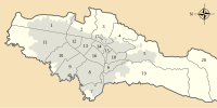
Engativá is the 10th locality of Bogotá. It is located in the west of the city. This district is mostly inhabited by lower middle and working class residents.

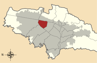
Chapinero Alto is one of 50 neighborhoods (barrios) in the locality of Chapinero in Bogotá, Colombia.

<span class="mw-page-title-main">Norte-Quito-Sur</span>

Avenida Norte-Quito-Sur or NQS is an arterial road in Bogotá, Colombia that crosses the city from northeast to southwest. The avenue is formed from the union of three old avenues, Avenida Ciudad de Quito, Avenida Novena, and Autopista Sur.

<span class="mw-page-title-main">Barrios Unidos</span> Locality of Bogotá in Bogotá D.C., Colombia

Barrios Unidos is the 12th locality of Bogotá, capital of Colombia. It is located to the northwest of the city, and is mostly inhabited by middle class residents. Barrios Unidos is completely urban, with some light industry and major commercial areas.

<span class="mw-page-title-main">Antonio Nariño, Bogotá</span> Locality of Bogotá in Bogotá D.C., Colombia

Antonio Nariño is the 15th locality of Bogotá, capital of Colombia. It is located in the central part of the city. This district is mostly inhabited by middle class residents. The locality is named after an early Colombian leader, Antonio Nariño, who is often referred to as the precursor to the presidency.

<span class="mw-page-title-main">Chapinero</span> Locality of Bogotá in Bogotá D.C., Colombia

Chapinero is the 2nd locality of Bogotá, capital of Colombia. It is located in the north of the city and is one of the more affluent districts of the city. This district is mostly inhabited by upper-class residents. The boundaries are Calle 39 in the south, Avenida Caracas in the west, Calle 100 in the north and the Eastern Hills in the east.

<span class="mw-page-title-main">Kennedy, Bogotá</span> Locality of Bogotá in Bogotá D.C., Colombia

Kennedy, or Ciudad Kennedy, is the eighth locality of Bogotá, capital of Colombia. It is located in the southwest of the city and is the second most populous being home to 14% of the city's residents. This district is mostly inhabited by working and low income residents.

<span class="mw-page-title-main">Los Mártires</span> Locality of Bogotá in Bogotá D.C., Colombia

Los Mártires is the 14th locality of Bogotá, capital of Colombia. It is located near the city's downtown to its west. This district is mostly inhabited by lower middle and working class residents. It takes its name in honor of those who died during the war for independence from Spain. It is completely urbanized, save for its parks and the banks of its rivers.

<span class="mw-page-title-main">San Cristóbal, Bogotá</span> Locality of Bogotá in Colombia

San Cristóbal, is the fourth locality of Bogotá, capital of Colombia. It is located in the southeast of Bogota. This district is mostly inhabited by lower class residents.

<span class="mw-page-title-main">Santa Fe, Bogotá</span> Locality of Bogotá in Bogotá D.C., Colombia

Santa Fe is the third locality of Bogotá, Capital District of Colombia. Santa Fe is part of the traditional downtown of the city of Bogotá, the area where the city was founded by Gonzalo Jiménez de Quesada on August 6, 1538. This area once comprised Bogotá's total main urban area and was known as "Santa Fe de Bogotá" with its traditional neighbourhoods.

<span class="mw-page-title-main">Usme</span> Locality of Bogotá in Bogotá D.C., Colombia

Usme is the 5th locality of the Capital District of Bogotá, capital city of Colombia. Usme is located in the south of Bogotá, bordering to the north the localities of San Cristóbal, Rafael Uribe Uribe and Tunjuelito, to the west the locality of Ciudad Bolívar, to the south the locality of Sumapaz, and to the east, behind the Eastern Hills, the municipalities of Ubaque, Chipaque and Une in the Department of Cundinamarca.

<span class="mw-page-title-main">Tunjuelito</span> Locality of Bogotá in Bogotá D.C., Colombia

Tunjuelito is the 6th locality of the Capital District of the Colombian capital, Bogotá. Tunjuelito is located in the south of Bogotá, bordering to the north with the localities of Bosa, Kennedy and Puente Aranda, to the east with the localities of Rafael Uribe Uribe and Usme, to the south with Usme and to the west with Ciudad Bolívar. This district is mostly inhabited by working and lower class residents.

<span class="mw-page-title-main">Suba, Bogotá</span> Locality of Bogotá in Bogotá D.C., Colombia

Suba is the 11th locality of Bogotá, capital of Colombia. It is located in the northwest of the city, bordering to the north the municipality of Chía in Cundinamarca, to the west the municipality of Cota, to the east the locality Usaquén and to the south the localities Engativá and Barrios Unidos. This district is inhabited by residents of all social classes.

<span class="mw-page-title-main">Puente Aranda</span> Locality of Bogotá in Bogotá D.C., Colombia

Puente Aranda is the 16th location of the Capital District of the Colombian capital city, Bogotá. It is located in the center part of Bogotá. This district is mostly inhabited by lower middle and working class residents. The district was named after an old bridge in the hacienda of Juan Aranda over the "Chinúa River", now called the San Francisco River, that dates to the 16th century. Puente Aranda has 1,724 hectares of area which are almost entirely urban. This locality has more than 300,000 inhabitants, 5% of the total urban area inhabitants of Bogota.

<span class="mw-page-title-main">Nicolás de Federmán, Bogotá</span> Barrio in Distrito Capital, Colombia

Nicolás de Federmán is a residential neighborhood located in Teusaquillo locality, near the geographical center of the city of Bogotá, Colombia. It is named after the prominent German conquistador of the 16th century Nikolaus Federmann, who took part in the re-founding of Bogotá on April 27, 1539 along with Spanish conqueror Sebastián de Belalcázar.

<span class="mw-page-title-main">Simón Bolívar Park</span> Urban park in Bogotá, Colombia

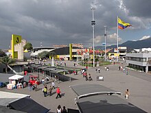
The Simón Bolívar Metropolitan Park, best known as the Simón Bolívar Park, is a greenspace and entertainment and sports complex located in the middle of the city of Bogotá, Colombia. It is one of the largest urban parks in the world with over 1000 acres of green spaces, bicycle paths, parks, sports complexes, a public library and the Bogota Botanical Gardens.

<span class="mw-page-title-main">Ciudad Salitre</span> Barrio in Distrito Capital, Colombia

Ciudad Salitre is a neighborhood (barrio), spanning the localities Teusaquillo and Fontibón of Bogotá, Colombia.

<span class="mw-page-title-main">Arzobispo River</span> River in Cundinamarca, Colombia

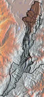
The Juan Amarillo, Arzobispo, or Salitre River is a river on the Bogotá savanna and a left tributary of the Bogotá River in Colombia. The river originates from various quebradas in the Eastern Hills and flows into the Bogotá River at the largest of the wetlands of Bogotá, Tibabuyes, also called Juan Amarillo Wetland. The total surface area of the Juan Amarillo basin, covering the localities Usaquén, Chapinero, Santa Fe, Suba, Barrios Unidos, Teusaquillo, and Engativá, is 12,892 hectares. Together with the Fucha and Tunjuelo Rivers, the Juan Amarillo River forms part of the left tributaries of the Bogotá River in the Colombian capital.

References

  1. (in Spanish) Population 2007 - DANE