Sumapaz

Last updated
Sumapaz
Locality of Bogotá
Distrito Capital de Bogota - Sumapaz.svg
Location of the locality in the Capital District of Bogotá
Coordinates: 4°15′36″N74°10′42″W / 4.26000°N 74.17833°W / 4.26000; -74.17833 Coordinates: 4°15′36″N74°10′42″W / 4.26000°N 74.17833°W / 4.26000; -74.17833
CountryFlag of Colombia.svg  Colombia
City Bogotá D.C.
Area
  Total 780.96 km2 (301.53 sq mi)
Elevation 3,500 m (11,500 ft)
Population (2007) [1]
  Total 5,667
  Density 7.3/km2 (19/sq mi)
Time zone Colombia Standard Time (UTC-5)
Website Official website

Sumapaz is the 20th locality of Bogotá, capital of Colombia. It is the largest of Bogotá's 20 localities, starting in the north at the edge of the urban frontier with Usme and stretching to the south at the border of Cundinamarca with the departments of Meta and Huila. It is completely rural, with no city services.

Bogotá Capital city in Colombia

Bogotá, officially Bogotá, Distrito Capital, abbreviated Bogotá, D.C., and formerly known as Santafé/Santa Fé de Bogotá between 1991 and 2000, is the capital and largest city of Colombia, administered as the Capital District, although often erroneously thought of as part of Cundinamarca. Bogotá is a territorial entity of the first order, with the same administrative status as the departments of Colombia. It is the political, economic, administrative, industrial, artistic, cultural, and sports center of the country.

Colombia Country in South America

Colombia, officially the Republic of Colombia, is a sovereign state largely situated in the northwest of South America, with territories in Central America. Colombia shares a border to the northwest with Panama, to the east with Venezuela and Brazil and to the south with Ecuador and Peru. It shares its maritime limits with Costa Rica, Nicaragua, Honduras, Jamaica, Haiti, and the Dominican Republic. Colombia is a unitary, constitutional republic comprising thirty-two departments, with the capital in Bogota.

Usme Locality of Bogotá in Bogotá D.C., Colombia

Usme is the 5th locality of the Capital District of Bogotá, capital city of Colombia. Usme is located in the south of Bogotá, bordering to the north the localities of San Cristóbal, Rafael Uribe Uribe and Tunjuelito, to the west the locality of Ciudad Bolívar, to the south the locality of Sumapaz, and to the east, behind the Eastern Hills, the municipalities of Ubaque, Chipaque and Une in the Department of Cundinamarca. This district is mostly inhabited by underclass residents.

Contents

History

The Sumapaz Páramo, covering most of the locality, was a sacred site for the indigenous Muisca in pre-Columbian times. In the 16th century, it was discovered by conquistadors led by Nicolaus Federmann in their quest for El Dorado .

Sumapaz Páramo mountain in Colombia

Sumapaz Páramo is a large páramo ecosystem located in the Altiplano Cundiboyacense mountain range, considered the largest páramo ecosystem in the world. It was declared a National Park of Colombia in 1977 because of its importance as a biodiversity hotspot and main source of water for the most densely populated area of the country, the Bogotá savanna.

Muisca ethnic group

The Muisca are an indigenous group of the Altiplano Cundiboyacense, Colombia, that formed the Muisca Confederation before the Spanish conquest. The people spoke Muysccubun, a language of the Chibcha language family, also called Muysca and Mosca. As one out of four advanced civilizations of the Americas, they were encountered by conquistadors ordered by the Spanish Empire in 1537 at the time of the conquest. Subgroupings of the Muisca were mostly identified by their allegiances to three great rulers: the zaque, centered in Hunza, ruling a territory roughly covering modern southern and northeastern Boyacá and southern Santander; the zipa, centered in Bacatá and encompassing most of modern Cundinamarca, the western Llanos; and the iraca, religious ruler of Suamox and modern northeastern Boyacá and southwestern Santander.

El Dorado South American myth

El Dorado, originally El Hombre Dorado or El Rey Dorado, was the term used by the Spanish Empire to describe a mythical tribal chief (zipa) of the Muisca native people in then Spanish colonial province of Colombia, who, as an initiation rite, covered himself with gold dust and submerged in Lake Guatavita. The legends surrounding El Dorado changed over time, as it went from being a man, to a city, to a kingdom, and then finally to an empire.

It has been the stage for several rural conflicts, including those of 1928 and 1946. La Violencia of 1948 gave rise to the formation of the guerrilla groups still present in Colombia. At the beginning of the 21st century, the Colombian army took the territory from guerrilla hands as part of a counter-guerrilla strategy of president Álvaro Uribe.

<i>La Violencia</i> civil war in Colombia between 1946 and 1958

La Violencia was a ten-year civil war in Colombia from 1948 to 1958, between the Colombian Conservative Party and the Colombian Liberal Party, fought mainly in the countryside.

Guerrilla warfare form of irregular warfare

Guerrilla warfare is a form of irregular warfare in which a small group of combatants, such as paramilitary personnel, armed civilians, or irregulars, use military tactics including ambushes, sabotage, raids, petty warfare, hit-and-run tactics, and mobility to fight a larger and less-mobile traditional military. Guerrilla groups are a type of violent non-state actor.

Álvaro Uribe Colombian lawyer and politician

Álvaro Uribe Vélez is a Colombian politician who served as the 31st President of Colombia from 7 August 2002 to 7 August 2010.

Economy

The population is dependent on small-scale farming and livestock.

General information

Borders

Une Municipality and town in Cundinamarca, Colombia

Une is a municipality and town of Colombia in the Eastern Province, part of the department of Cundinamarca. The urban centre is located at an altitude of 2,376 metres (7,795 ft) at a distance of 43 kilometres (27 mi) from the capital Bogotá. The municipality borders Chipaque in the north, Cáqueza and Fosca in the east, Fosca and Gutiérrez in the south and Bogotá in the west.

Gutiérrez, Cundinamarca Municipality and town in Cundinamarca, Colombia

Gutiérrez is a municipality and town of Colombia in the department of Cundinamarca.

Cabrera, Cundinamarca Municipality and town in Cundinamarca, Colombia

Cabrera is a town and municipality in Sumapaz Province in Cundinamarca Department, Colombia. This town was founded in the 1920s. It is located 4 hours from Bogota and its area is known by the production of livestock, fruit and more recently the best variety of beans in the world in the mid-1990s.

Hydrology

Within the borders of the locality, several rivers are formed, mostly within Sumapaz National Park. The two largest rivers are the Pilar and Sumapaz River, the latter flowing into the Magdalena River.

Sumapaz River

The Sumapaz River is a major tributary of the Magdalena River in Colombia. The 95 kilometres (59 mi) long river originates in the Eastern Ranges of the Colombian Andes at the largest páramo in the world; Sumapaz, of which it takes its name. It forms the natural boundary between the departments of Cundinamarca and Tolima.

Magdalena River river in Colombia

The Magdalena River is the principal river of Colombia, flowing northward about 1,528 kilometres (949 mi) through the western half of the country. It takes its name from the biblical figure Mary Magdalene. It is navigable through much of its lower reaches, in spite of the shifting sand bars at the mouth of its delta, as far as Honda, at the downstream base of its rapids. It flows through the Magdalena River Valley.

Points of interest

Related Research Articles

Vichada Department Department in Orinoquía Region, Colombia

Vichada Department is a department of the Republic of Colombia in South America. Vichada is located in the eastern plains of Colombia, in the Orinoquía Region within the Orinoco river basin bordering the Bolivarian Republic of Venezuela to the north and east. To the north the department also borders with Arauca Department, to the northwest with Casanare Department, to the west with Meta Department, to the southwest narrowly bordering with Guaviare Department and to the south with Guainía Department. The department is the second largest in Colombia and scarcely populated in comparison to other departments.

Pasca Town and municipality in Cundinamarca, Colombia

Pasca is a town and municipality in the Cundinamarca department of Colombia located in the Andes. It belongs to the Sumapaz Province. Pasca is situated on the Altiplano Cundiboyacense at a distance of 71 kilometres (44 mi) from the capital Bogotá. It borders Fusagasugá, Sibaté and Soacha in the north, Bogotá D.C. in the north and east, Arbeláez in the south and Fusagasugá in the west. The urban center is located at an altitude of 2,180 metres (7,150 ft) and the altitude ranges from 2,000 metres (6,600 ft) to 3,500 metres (11,500 ft).

Melgar, Tolima Place in Tolima, Colombia

Melgar is a Colombian town in the Department of Tolima, 98 km (61 mi) southwest of Bogotá and 1 hour east of Ibagué, the capital city of Tolima.

Cordillera Oriental (Colombia) mountain range in Colombia

The Cordillera Oriental is the widest of the three branches of the Colombian Andes. The range extends from south to north dividing from the Colombian Massif in Huila Department to Norte de Santander Department where it splits into the Serranía del Perijá and the Cordillera de Mérida in Venezuelan Andes. The highest peak is Ritacuba Blanco at 5,410 m (17,750 ft) in the Sierra Nevada del Cocuy.

Barrios Unidos Locality of Bogotá in Bogotá D.C., Colombia

Barrios Unidos is the 12th locality of Bogotá, capital of Colombia. It is located in the northwest of the city. This district is mostly inhabited by middle class residents. Barrios Unidos is completely urban, with some light industry and major commercial areas.

Antonio Nariño, Bogotá Locality of Bogotá in Bogotá D.C., Colombia

Antonio Nariño is the 15th locality of Bogotá, capital of Colombia. It is located in the south of the city. This district is mostly inhabited by lower middle and working class residents. The locality is named after an early Colombian leader, Antonio Nariño, who is often referred to as the precursor to the presidency.

Chapinero Locality of Bogotá in Bogotá D.C., Colombia

Chapinero is the 2nd locality of Bogotá, capital of Colombia. It is located in the north of the city and is one of the more affluent districts of the city. This district is mostly inhabited by upper class residents. The boundaries are Calle 39 in the south, Avenida Caracas in the west, Calle 100 in the north and the Eastern Hills in the east.

Kennedy, Bogotá Locality of Bogotá in Bogotá D.C., Colombia

Kennedy, or Ciudad Kennedy, is the eighth locality of Bogotá, capital of Colombia. It is located in the southwest of the city and is the second most populous being home to 14% of the city's residents. This district is mostly inhabited by working and lower class residents.

Teusaquillo Locality of Bogotá in Bogotá D.C., Colombia

Teusaquillo is the 13th locality of Bogotá, capital of Colombia. It is located in the geographic center of the city, to the northwest of downtown Bogotá. This district is inhabited by middle class residents. It is an urbanized locality with several green zones as parks, avenues, and the campus of the National University of Colombia. It is located on the former site of an indigenous resguardo known as Pueblo Viejo, which existed until the main urbanization phase of the 20th century.

San Cristóbal, Bogotá Locality of Bogotá in Colombia

San Cristóbal, is the fourth locality of Bogotá, capital of Colombia. It is located in the southeast of Bogota. This district is mostly inhabited by lower class residents.

Tunjuelito Locality of Bogotá in Bogotá D.C., Colombia

Tunjuelito is the 6th locality of the Capital District of the Colombian capital, Bogotá. Tunjuelito is located in the south of Bogotá, bordering to the north with the localities of Bosa, Kennedy and Puente Aranda, to the east with the localities of Rafael Uribe Uribe and Usme, to the south with Usme and to the west with Ciudad Bolívar. This district is mostly inhabited by working and lower class residents.

Ciudad Bolívar, Bogotá Locality of Bogotá in Bogotá D.C., Colombia

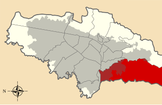
Ciudad Bolívar is the 19th locality in the Capital District of the Colombian capital city Bogotá. Ciudad Bolívar is located in the south of the city at the southern border of the Bogotá savanna. This district is mostly inhabited by underclass residents.

Chingaza National Natural Park national park

Chingaza National Natural Park is located in the Eastern Ranges of the Colombian Andes, northeast of Bogotá, Colombia in the departments of Cundinamarca and Meta. The elevation in the park, to the east of the Altiplano Cundiboyacense, ranges from 800 metres (2,600 ft) to 4,020 metres (13,190 ft), and the temperature ranges from 4 to 21.5 °C. The park extends over the Cundinamarca municipalities La Calera, Fómeque, Guasca and San Juanito (Meta).

Eastern Hills, Bogotá

The Eastern Hills are a chain of hills forming the eastern natural boundary of the Colombian capital Bogotá. They are part of the Altiplano Cundiboyacense, the high plateau of the Eastern Ranges of the Colombian Andes. The Eastern Hills are bordered by the Chingaza National Natural Park to the east, the Bogotá savanna to the west and north, and the Sumapaz Páramo to the south. The north-northeast to south-southwest trending mountain chain is 52 kilometres (32 mi) long and its width varies from 0.4 to 8 kilometres. The highest hilltops rise to 3,550 metres (11,650 ft) over the western flatlands at 2,600 metres (8,500 ft). The Torca River at the border with Chía in the north, the boquerón Chipaque to the south and the valley of the Teusacá River to the east are the hydrographic limits of the Eastern Hills.

Tunjuelo River

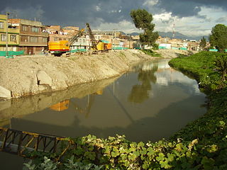
The Tunjuelo or Tunjuelito River is a river on the Bogotá savanna and a left tributary of the Bogotá River. The river, with a length of 73 kilometres (45 mi) originates in the Sumapaz Páramo and flows northward through the Usme Synclinal to enter the Colombian capital Bogotá. There, the river is mostly canalised flowing westward into the Bogotá River. It is one of the three main rivers of the city, together with the Fucha and Juan Amarillo Rivers.

Usme Fault

The Usme Fault is a dextral oblique normal fault in the department of Cundinamarca in central Colombia. The fault has a total length of 64.9 kilometres (40.3 mi) and runs along an average north-northeast to south-southwest strike of 022.7 ± 6 in the Eastern Ranges of the Colombian Andes.

References

  1. (in Spanish) Population 2007 - DANE