The Muisca are an indigenous people and culture of the Altiplano Cundiboyacense, Colombia, that formed the Muisca Confederation before the Spanish conquest. The people spoke Muysccubun, a language of the Chibchan language family, also called Muysca and Mosca. They were encountered by conquistadors dispatched by the Spanish Empire in 1537 at the time of the conquest. Subgroupings of the Muisca were mostly identified by their allegiances to three great rulers: the hoa, centered in Hunza, ruling a territory roughly covering modern southern and northeastern Boyacá and southern Santander; the psihipqua, centered in Muyquytá and encompassing most of modern Cundinamarca, the western Llanos; and the iraca, religious ruler of Suamox and modern northeastern Boyacá and southwestern Santander.

Zoratama, also spelled as Soratama, was a Muisca woman and the lover of Spanish conquistador Lázaro Fonte. Her story reminds of the North American indigenous Pocahontas who married John Rolfe after saving the life of John Smith.

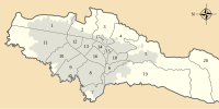
Fontibon is the 9th locality of Bogotá. It is located in the west of the city. This district is mostly inhabited by low and middle class residents.
Bojacá is a municipality and town of the Western Savanna Province, Colombia in the department of Cundinamarca. The urban centre is situated at an altitude of 2,598 metres (8,524 ft) on the Bogotá savanna at 40 kilometres (25 mi) from the capital Bogotá. The municipality borders Zipacón, Madrid and Facatativá in the north, Madrid and Mosquera in the east, Soacha and San Antonio del Tequendama in the south and Tena, La Mesa and Zipacón in the west.

Funza is a municipality and town of Colombia in the Western Savanna Province, of the department of Cundinamarca. Funza is situated on the Bogotá savanna, the southwestern part of the Altiplano Cundiboyacense with the urban centre at an altitude of 2,548 metres (8,360 ft). In Funza the La Florida wetland, part of the wetlands of Bogotá, a remnant of the Pleistocene Lake Humboldt, still exists. The town is part of the Metropolitan Area of Bogotá and borders Madrid and Tenjo in the north, Mosquera in the south, Madrid in the west and Cota and the locality Engativá of the capital Bogotá in the east. The eastern boundary is formed by the Bogotá River. Funza is the site of the former main settlement Bacatá of the Muisca Confederation. Modern Funza was founded by Gonzalo Jiménez de Quesada during the Spanish conquest of the Muisca on April 20, 1537.

Mosquera is a municipality of Colombia in the Western Savanna Province, part of the department of Cundinamarca. Mosquera is close to the capital Bogotá and is part of its metropolitan area. The urban centre of Mosquera is situated at an altitude of 2,516 metres (8,255 ft) on the Bogotá savanna. The municipality borders the localities Bosa and Fontibón of Bogotá in the east, Soacha in the south, Madrid and Funza in the north and Bojacá in the west.

San Antonio del Tequendama is a municipality and town of Colombia in the Tequendama Province part of the department of Cundinamarca. The municipality is located along the Serranía de Subía in the Tena Valley and borders Tena and Bojacá in the north, Bojacá and Soacha in the east, La Mesa and El Colegio in the west and in the south Soacha and Granada.

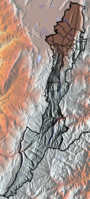
The Bogotá savanna is a montane savanna, located in the southwestern part of the Altiplano Cundiboyacense in the center of Colombia. The Bogotá savanna has an extent of 4,251.6 square kilometres (1,641.6 sq mi) and an average altitude of 2,650 metres (8,690 ft). The savanna is situated in the Eastern Ranges of the Colombian Andes.

Techo is a neighbourhood (barrio) of Bogotá, Colombia, part of the locality Kennedy. It contains a wetland of the same name, part of the Wetlands of Bogotá, Colombia. The wetland covers about 11 hectares.
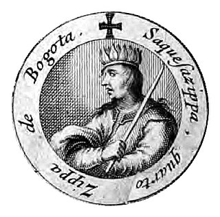
Sagipa or Zaquesazipa was the fifth and last ruler (psihipqua) of Muyquytá, currently known as Bogota, as of 1537. He was the brother of his predecessor Bogotá but the traditional faction of the Muisca considered him an usurper as his nephew Chiayzaque, the cacique of Chía, was the legitimate successor of Tisquesusa. His hoa counterpart in the northern part of the Muisca territory was Quiminza, the last surviving ruler of the Muisca. The daughter of Sagipa, named as Magdalena de Guatavita, married conquistador Hernán Venegas Carrillo, one of the first mestizo marriages in the New Kingdom of Granada.

Tisquesusa, also spelled Thisquesuza, Thysquesuca or Thisquesusha was the fourth and last independent ruler (psihipqua) of Muyquytá, main settlement of the southern Muisca between 1514 and his death in 1537. The Spanish pronunciation of his name brought about the Colombian capital Bogotá. Tisquesusa was the ruler of the southern Muisca Confederation at the time of the Spanish conquest of the Muisca, when the troops led by Gonzalo Jiménez de Quesada and his brother entered the central Andean highlands.
This article describes the architecture of the Muisca. The Muisca, inhabiting the central highlands of the Colombian Andes, were one of the four great civilizations of the Americas. Unlike the three civilizations in present-day Mexico and Peru, they did not construct grand architecture of solid materials. While specialising in agriculture and gold-working, cloths and ceramics, their architecture was rather modest and made of non-permanent materials as wood and clay.
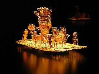
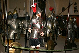
The Spanish conquest of the Muisca took place from 1537 to 1540. The Muisca were the inhabitants of the central Andean highlands of Colombia before the arrival of the Spanish conquistadors. They were organised in a loose confederation of different rulers; the psihipqua of Muyquytá, with his headquarters in Funza, the hoa of Hunza, the iraca of the sacred City of the Sun Sugamuxi, the Tundama of Tundama, and several other independent caciques. The most important rulers at the time of the conquest were psihipqua Tisquesusa, hoa Eucaneme, iraca Sugamuxi and Tundama in the northernmost portion of their territories. The Muisca were organised in small communities of circular enclosures, with a central square where the bohío of the cacique was located. They were called "Salt People" because of their extraction of salt in various locations throughout their territories, mainly in Zipaquirá, Nemocón, and Tausa. For the main part self-sufficient in their well-organised economy, the Muisca traded with the European conquistadors valuable products as gold, tumbaga, and emeralds with their neighbouring indigenous groups. In the Tenza Valley, to the east of the Altiplano Cundiboyacense where the majority of the Muisca lived, they extracted emeralds in Chivor and Somondoco. The economy of the Muisca was rooted in their agriculture with main products maize, yuca, potatoes, and various other cultivations elaborated on elevated fields. Agriculture had started around 3000 BCE on the Altiplano, following the preceramic Herrera Period and a long epoch of hunter-gatherers since the late Pleistocene. The earliest archaeological evidence of inhabitation in Colombia, and one of the oldest in South America, has been found in El Abra, dating to around 12,500 years BP.
Hernán Pérez de Quesada, sometimes spelled as Quezada, was a Spanish conquistador. Second in command of the army of his elder brother, Gonzalo Jiménez de Quesada, Hernán was part of the first European expedition towards the inner highlands of the Colombian Andes. The harsh journey, taking almost a year and many deaths, led through the modern departments Magdalena, Cesar, Santander, Boyacá, Cundinamarca and Huila of present-day Colombia between 1536 and 1539 and, without him, Meta, Caquetá and Putumayo of Colombia and northern Peru and Ecuador between 1540 and 1542.

Juan Rodríguez Freyle, was an early writer in the New Kingdom of Granada, the Spanish colonial territory of what today is Colombia, Ecuador, Panama and Venezuela. The son of a soldier in the army of Pedro de Ursúa, Rodríguez Freyle knew the cacique of Guatavita and the founder of Bogotá: Gonzalo Jiménez de Quesada. His major work El Carnero is a collection of stories, anecdotes and rumours about the early days of the New Kingdom of Granada and the demise of the Muisca Confederation. It is one of the most important sources for the sixteenth century Spanish period of present-day Colombia.
Baltasar Maldonado, also written as Baltazar Maldonado, was a Spanish conquistador who first served under Gonzalo Jiménez de Quesada, and later in the army of Hernán Pérez de Quesada in the Spanish conquest of the Muisca.

The Battle of Tocarema was a battle fought between an alliance of the troops of Spanish conquistador Gonzalo Jiménez de Quesada and zipa of the Muisca Sagipa of the southern Muisca Confederation and the indigenous Panche. The battle took place on the afternoon of August 19 and the morning of August 20, 1538 in the vereda Tocarema of Cachipay, Cundinamarca, Colombia and resulted in a victory for the Spanish and Muisca, when captains Juan de Céspedes and Juan de Sanct Martín commanded two flanks of the conquistadors.
The Cabildo Mayor del Pueblo Muisca is an organisation of indigenous people, in particular the Muisca. It was established in September 2002 in Bosa, Bogotá, Colombia. The organisation, member of National Indigenous Organization of Colombia (ONIC), focuses on defending the rights of the descendants of the Muisca, and the development of cultural and historical heritage, territory and health and the linguistics of the indigenous language, Muysccubun.

The Fucha River is a river on the Bogotá savanna and a left tributary of the Bogotá River. The river originates in the Eastern Hills of the Colombian capital Bogotá and flows westward through the city into the Bogotá River. It is one of the three important rivers of the city, together with the Tunjuelo and Juan Amarillo Rivers.
Juan Tafur was a Spanish conquistador who participated in the Spanish conquest of the Muisca people. He was a cousin of fellow conquistadors Martín Yañéz Tafur, Hernán Venegas Carrillo and Pedro Fernández de Valenzuela. Juan Tafur was five times encomendero (mayor) of Santa Fe de Bogotá. He also received the encomiendas of Pasca, Chipaque and Usaquén. The encomienda of Suesca was shared between Tafur and Gonzalo García Zorro.