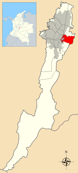
Santa Fe (Spanish pronunciation:[santaˈfe]) is the third locality of Bogotá, the Capital District of Colombia. Santa Fe is part of the traditional downtown area where Bogotá was founded by Gonzalo Jiménez de Quesada on August 6, 1538. Historically, this area comprised the entire main urban area of Bogotá, and was known as "Santa Fe de Bogotá".
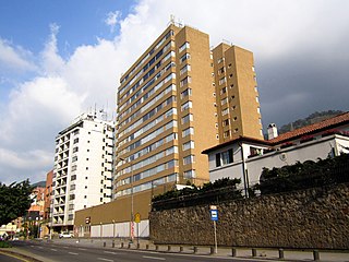
Santa Fe hosts several key business districts in Bogotá, and is served by Carrera Séptima, one of the city's major thoroughfares. The locality is home to many of Bogotá's skyscrapers, including the International Center and the financial district along Avenida Jiménez.
The main streets of central Bogotá intersect in Santa Fe, including Carrera Séptima (formerly Calle Real), Carrera Décima, Calle 26, Avenida Circunvalar, Avenida Caracas, Avenida Ciudad de Lima, and Avenida Jiménez.
Santa Fe also includes a rural area in the Eastern Hills where Monserrate and Guadalupe are prominent landmarks. The locality of La Candelaria which was the original site of the founding of Santa Fe de Bogotá, is now an enclave within Santa Fe. La Candelaria was separated from Santa Fe following the establishment of the Capital District.
In the early 20th century, the city was primarily confined to the present boundaries of Santa Fe. Urbanization began to expand towards Chapinero in the 1920s, and further west in the 1950s. This westward expansion followed the destruction caused by El Bogotazo, a period of violent unrest that damaged many streets.
In 1972, Santa Fe was established as a minor city hall. With the Constitutional reform of 1991, Santa Fe was officially designated as a locality (or a Local Action Board) within the Capital District.
General data
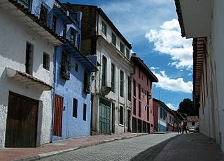
Street in Las Nieves
Santa Fe had a population of 107,044 people according to the 1993 census. Its average temperature is 13°C (55°F). It has a total area of 4,487.74 hectares (11,089.4 acres) and an urban area of 662.06 hectares (1,636.0 acres).
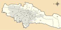
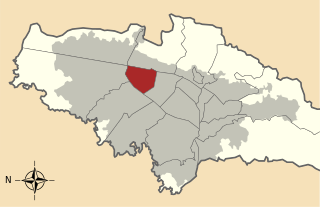
Among the neighbourhoods there are Las Cruces, Los Laches, La Perseverancia, La Concordia, Santa Inés, Santa Bárbara, San Bernardo, La Merced, Egipto, Germania, Las Aguas, La Paz, La Peña, Liévano, Las Nieves, El Consuelo, Belén, Egipto Alto, Central, El Rocío, Tisquesuza, La Macarena and El Bosque Izquierdo. Veredas are Monserrate and El Vergel.
Santa Fe is crossed by the San Francisco River, San Agustín River, Arzobispo River and San Cristóbal River. Because of its proximity to the Eastern Hills, the urban area near these mountains is tilted some 40 degrees.
Bogotá, officially Bogotá, Distrito Capital, abbreviated Bogotá, D.C., and formerly known as Santa Fe de Bogotá during the Spanish Colonial period and between 1991 and 2000, is the capital and largest city of Colombia, and one of the largest cities in the world. The city is administered as the Capital District, as well as the capital of, though not politically part of, the surrounding department of Cundinamarca. Bogotá is a territorial entity of the first order, with the same administrative status as the departments of Colombia. It is the main political, economic, administrative, industrial, cultural, airport, technological, scientific, healthcare and educational center of the country and northern South America.
Avenida Jiménez is a transfer station, part of the TransMilenio mass-transit system of Bogotá, Colombia.
Avenida Caracas is an arterial road in Bogotá, Colombia that runs through the city from north to south.
Autopista Norte, also called Autopista paseo de los libertadores, is a major road in Bogotá, Colombia, running through the northern part of the city to its southern end at Avenida Caracas.
Barrios Unidos is the 12th locality of Bogotá, capital of Colombia. It is located to the northwest of the city, and is mostly inhabited by middle class residents. Barrios Unidos is completely urban, with some light industry and major commercial areas.
Antonio Nariño is the 15th locality of Bogotá, capital of Colombia. It is located in the central part of the city. This district is mostly inhabited by middle class residents. The locality is named after an early Colombian leader, Antonio Nariño, who is often referred to as the precursor to the presidency.
Chapinero is the 2nd locality of Bogotá, capital of Colombia. It is located in the north of the city and is one of the more affluent districts of the city. This district is mostly inhabited by upper-class residents. The boundaries are Calle 39 in the south, Avenida Caracas in the west, Calle 100 in the north and the Eastern Hills in the east.
Rosales is a barrio in the Chapinero locality of Bogotá.
Los Mártires is the 14th locality of Bogotá, capital of Colombia. It is located near the city's downtown to its west. This district is mostly inhabited by lower middle and working class residents. It takes its name in honor of those who died during the war for independence from Spain. It is completely urbanized, save for its parks and the banks of its rivers.
Teusaquillo is the 13th locality of Bogotá, capital of Colombia. It is located in the geographic center of the city, to the northwest of downtown Bogotá. This district is inhabited by middle and upper class residents. It is an urbanized locality with several green zones as parks, avenues, and the campus of the National University of Colombia. Most of the heritage buildings and houses of Bogotá are in this locality. It is located on the former site of an indigenous resguardo known as Pueblo Viejo, which existed until the main urbanization phase of the 20th century.
La Candelaria is the 17th locality of Bogotá, Colombia. It is a historic neighborhood located in the city's downtown area, similar to the Old City in other cities. The architecture in La Candelaria features Spanish Colonial Baroque, and art deco styles. The locality is home to several universities, libraries, and museums.
San Cristóbal, is the fourth locality of Bogotá, capital of Colombia. It is located in the southeast of Bogota. This district is mostly inhabited by lower class residents.
Suba is the 11th locality of Bogotá, capital of Colombia. It is located in the northwest of the city, bordering to the north the municipality of Chía in Cundinamarca, to the west the municipality of Cota, to the east the locality Usaquén and to the south the localities Engativá and Barrios Unidos. This district is inhabited by residents of all social classes.
Puente Aranda is the 16th location of the Capital District of the Colombian capital city, Bogotá. It is located in the center part of Bogotá. This district is mostly inhabited by lower middle and working class residents. The district was named after an old bridge in the hacienda of Juan Aranda over the "Chinúa River", now called the San Francisco River, that dates to the 16th century. Puente Aranda has 1,724 hectares of area which are almost entirely urban. This locality has more than 300,000 inhabitants, 5% of the total urban area inhabitants of Bogota.
Rafael Uribe Uribe is the 18th locality of the Capital District in the Colombian capital Bogotá. This district is mostly inhabited by working and lower class residents. It was named after the Liberal General Rafael Uribe Uribe. Historically, it has been a predominantly residential area with minor commercial activity. Since the 1940s, urban expansion began from the flat Bogotá savanna towards higher elevations. Nowadays, the locality's southern part is undergoing urban expansion.
Carrera Séptima, also known as Eduardo Posada Flórez Avenue, is one of the principal transit arteries which crosses the eastern side of Bogotá north and south. It is the most important thoroughfare of the city in the sense of history, culture, economy, and society. Carrera Séptima is bound to the east by the Eastern Hills.
La Perseverancia is a neighborhood of the UPZ of La Macarena, situated in the Santa Fe locality of the capital of Colombia, Bogotá. It is located in the eastern edge of the city. It was founded in the beginning of the 20th century as a working neighborhood situated on the outskirts of the urban perimeter. Its growth accompanied the development of the Bavaria brewery, in the nearby San Diego neighborhood.
Marly is a neighbourhood in the locality of Chapinero in Bogotá, Colombia.
The Juan Amarillo, Arzobispo, or Salitre River is a river on the Bogotá savanna and a left tributary of the Bogotá River in Colombia. The river originates from various quebradas in the Eastern Hills and flows into the Bogotá River at the largest of the wetlands of Bogotá, Tibabuyes, also called Juan Amarillo Wetland. The total surface area of the Juan Amarillo basin, covering the localities Usaquén, Chapinero, Santa Fe, Suba, Barrios Unidos, Teusaquillo, and Engativá, is 12,892 hectares. Together with the Fucha and Tunjuelo Rivers, the Juan Amarillo River forms part of the left tributaries of the Bogotá River in the Colombian capital.
Avenida Jiménez is a thoroughfare that runs through the locality of La Candelaria in Bogotá, Colombia. Laid out on the San Francisco River, the Environmental Axis of the city is currently established there.
This page is based on this Wikipedia article Text is available under the CC BY-SA 4.0 license; additional terms may apply. Images, videos and audio are available under their respective licenses.