Natural hazards in Colombia

Last updated
The 1985 Armero tragedy is the worst natural disaster in Colombian history Armerodisaster.png
The 1985 Armero tragedy is the worst natural disaster in Colombian history

Natural disasters in Colombia are the result of several different natural hazards that affect the country according to its particular geographic and geologic features. Human vulnerability, exacerbated by the lack of planning or lack of appropriate emergency management, and the fragility of the economy and infrastructure contribute to a high rate of financial, structural, and human losses.

Contents

Some of the natural hazards present in Colombia are:

Geologic

Colombia is part of the Pacific Ring of Fire and Andean Volcanic Belt due to the collision of the South American Plate and the Nazca Plate. This produces an increased risk of earthquakes and volcanic eruptions. Some natural disasters of this type are:

Hydrologic

Flooding in Colombia, April 2004 Colombia.A2004117.1535.250m.jpg
Flooding in Colombia, April 2004

Rainfall is heaviest in the Pacific lowlands and in parts of eastern Colombia, where rain is almost a daily occurrence and rain forests predominate. Precipitation exceeds 760 centimeters annually in most of the Pacific lowlands, making this one of the wettest regions in the world. The highest average annual precipitation in the world is estimated to be in Lloro, Colombia, with 13,299 mm (523.9 inches). [2] In eastern Colombia, it decreases from 635 centimeters in portions of the Andean piedmont to 254 centimeters eastward. Extensive areas of the Caribbean interior are permanently flooded, more because of poor drainage than because of the moderately heavy precipitation during the rainy season. The Caribbean Region of Colombia, valleys of Magdalena river and Cauca river and the eastern savannahs are prone to floods during the two main monsoon seasons (April and November). The opposite phenomenon of drought is also frequent. January through March and July through September are the dry seasons, when abnormally dry periods cause shortage in the water supply to crops and urban centers.
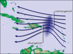
Climatic

Diagram of converging and diverging winds north to the Caribbean Region of Colombia Atlantic hurricane graphic.png
Diagram of converging and diverging winds north to the Caribbean Region of Colombia

The presence of coastal regions both in the Atlantic and the Pacific oceans increases the risk of hurricanes and tropical storms. Waves in the trade winds in the Atlantic Ocean—areas of converging winds that move along the same track as the prevailing wind—create instabilities in the atmosphere that may lead to the formation of hurricanes. Some of the events of this type that have affected the country are:

Health and disease

Worldwide dengue distribution, 2006. Red: Epidemic dengue fever. Blue: Aedes aegypti. Dengue06.png
Worldwide dengue distribution, 2006. Red: Epidemic dengue fever. Blue: Aedes aegypti .

Some of the main public health issues in Colombia are: malnutrition, pregnancy-related deaths, neonatal deaths, acute respiratory disease-related deaths in children under 5 years, diarrhea-related deaths in children under 5 years, lack of vaccinations, tropical diseases such as malaria, dengue fever, hemorrhagic dengue fever, yellow fever, Chagas disease and leishmaniasis, poly-parasitism, snakebites and violence related causes of mortality.

Related Research Articles

Geography of Colombia

The Republic of Colombia is situated largely in the northwest of South America, with some territories falling within the boundaries of Central America. It is bordered to the northwest by Panama; to the east by Venezuela and Brazil; to the south by Ecuador and Peru; and it shares maritime limits with Costa Rica, Nicaragua, Honduras, Jamaica, the Dominican Republic, and Haiti.

Geography of El Salvador Overview of countrys geological attributes

El Salvador borders the North Pacific Ocean to the south and southwest, with Guatemala to the north-northwest and Honduras to the north-northeast. In the southeast, the Golfo de Fonseca separates it from Nicaragua. El Salvador is the smallest Central American country and is the only one without a coastline on the Caribbean sea. El Salvador is about the same size of Israel and the U.S states of New Jersey and Vermont.

Geography of Honduras

Honduras is a country in Central America. Honduras borders the Caribbean Sea and the North Pacific Ocean. Guatemala lies to the west, Nicaragua south east and El Salvador to the south west. Honduras is the second largest Central American republic, with a total area of 112,890 square kilometres (43,590 sq mi).

Geography of Nicaragua

Nicaragua is a country in Central America, bordering both the Caribbean Sea and the North Pacific Ocean, between Costa Rica and Honduras. Nicaragua is the largest country in Central America in square kilometers.

Geography of Panama

Panama is a country located in Central America, bordering both the Caribbean Sea and the Pacific Ocean, between Colombia and Costa Rica. Panama is located on the narrow and low Isthmus of Panama.

Geography of the United States Overview of the geography of the United States

The term "United States", when used in the geographical sense, is the contiguous United States, the state of Alaska, the island state of Hawaii, the five insular territories of Puerto Rico, Northern Mariana Islands, U.S. Virgin Islands, Guam, and American Samoa, and minor outlying possessions. The United States shares land borders with Canada and Mexico and maritime borders with Russia, Cuba, the Bahamas, and other countries, in addition to Canada and Mexico. The northern border of the United States with Canada is the world's longest bi-national land border.

Geography of Guatemala

Guatemala is mountainous, except for the south coastal area and the vast northern lowlands of Petén department. The country is located in Central America, bordering the Caribbean Sea, between Honduras and Belize and bordering the North Pacific Ocean, between El Salvador and Mexico. Two mountain chains enter Guatemala from west to east, dividing the country into three major regions: the highlands, where the mountains are located; the Pacific coast, south of the mountains; and the limestone plateau of the Petén region, north of the mountains. These areas vary in climate, elevation, and landscape, providing dramatic contrasts between hot and humid tropical lowlands and highland peaks and valleys.

Natural disaster Major adverse event resulting from natural processes of the Earth

A natural disaster is a major adverse event resulting from natural processes of the Earth; examples include floods, hurricanes, tornadoes, volcanic eruptions, earthquakes, tsunamis, storms, and other geologic processes. A natural disaster can cause loss of life or damage property, and typically leaves some economic damage in its wake, the severity of which depends on the affected population's resilience and on the infrastructure available.

Stratovolcano Type of conical volcano composed of layers of lava and tephra

A stratovolcano, also known as a composite volcano, is a conical volcano built up by many layers (strata) of hardened lava and tephra. Unlike shield volcanoes, stratovolcanoes are characterized by a steep profile with a summit crater and periodic intervals of explosive eruptions and effusive eruptions, although some have collapsed summit craters called calderas. The lava flowing from stratovolcanoes typically cools and hardens before spreading far, due to high viscosity. The magma forming this lava is often felsic, having high-to-intermediate levels of silica, with lesser amounts of less-viscous mafic magma. Extensive felsic lava flows are uncommon, but have travelled as far as 15 km (9.3 mi).

Ring of Fire Area of high earthquake and volcanic activity, also the circum-Pacific belt

The Ring of Fire is a region around much of the rim of the Pacific Ocean where many volcanic eruptions and earthquakes occur. The Ring of Fire is a horseshoe-shaped belt about 40,000 km (25,000 mi) long and up to about 500 km (310 mi) wide.

Nevado del Ruiz Volcanic mountain in Colombia

The Nevado del Ruiz, also known as La Mesa de Herveo is a volcano on the border of the departments of Caldas and Tolima in Colombia, about 129 kilometers (80 mi) west of the capital city Bogotá. It is a stratovolcano composed of many layers of lava alternating with hardened volcanic ash and other pyroclastic rocks. Volcanic activity at Nevado del Ruiz began about two million years ago, since the Early Pleistocene or Late Pliocene, with three major eruptive periods. The current volcanic cone formed during the present eruptive period, which began 150,000 years ago.

Cerro Azul (Chile volcano) Mountain in Curicó Province, Chile

Cerro Azul, sometimes referred to as Quizapu, is an active stratovolcano in the Maule Region of central Chile, immediately south of Descabezado Grande. Part of the South Volcanic Zone of the Andes, its summit is 3,788 meters (12,428 ft) above sea level, and is capped by a summit crater that is 500 meters (1,600 ft) wide and opens to the north. Beneath the summit, the volcano features numerous scoria cones and flank vents.

Armero tragedy November 1985 volcanic eruption in Colombia

The Armero tragedy occurred following the eruption of the Nevado del Ruiz stratovolcano in Tolima, Colombia, on November 13, 1985. After 69 years of dormancy, the volcano's eruption caught nearby towns unaware, even though the government had received warnings from volcanological organizations to evacuate the area after the detection of volcanic activity two months earlier.

Hurricane Pauline

Hurricane Pauline was one of the deadliest Pacific hurricanes to make landfall in Mexico. The sixteenth tropical storm, eighth hurricane, and seventh major hurricane of the 1997 Pacific hurricane season, Pauline developed out of a tropical wave from Africa on September 16, 1997, moving across South America and into the Pacific Ocean. On October 5, the depression intensified into a tropical storm early the next day and by October 7, Pauline had reached hurricane intensity. It initially moved eastward, then turned northwestward and quickly strengthened to reach peak winds of 135 mph (215 km/h). It paralleled the Mexican coastline a short distance offshore before weakening and making landfall near Puerto Angel, on October 9, and dissipated the next day.

A natural hazard is a natural phenomenon that might have a negative effect on humans and other animals, or the environment. Natural hazard events can be classified into two broad categories: geophysical and biological.

Geology of Colombia

Geology of Colombia refers to the geological composition of the Republic of Colombia that determines its geography. Most of the emerged territory of Colombia covers vast areas within the South American plate, whereas much submerged territory lies within the Caribbean plate and the Nazca plate.

The following outline is provided as an overview of and topical guide to tropical cyclones:

The Office of U.S. Foreign Disaster Assistance (OFDA) is an organizational unit within the United States Agency for International Development (USAID) that is charged by the President of the United States with directing and coordinating international United States government disaster assistance.

References

  1. "Natural disasters - Colombia travel advice". GOV.UK. Retrieved 2020-09-29.
  2. Global Measured Extremes of Temperature and Precipitation. National Climatic Data Center . August 9, 2005. Last accessed January 18, 2007.