
The Republic of Colombia is situated largely in the north-west of South America, with some territories falling within the boundaries of Central America. It is bordered to the north-west by Panama; to the east by Brazil and Venezuela; to the south by Ecuador and Peru; and it shares maritime limits with Costa Rica, Nicaragua, Honduras, Jamaica, the Dominican Republic, and Haiti.
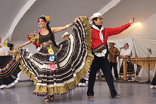
Many aspects of Colombian culture can be traced back to the early culture of Spain of the 16th century and its collision with Colombia's native civilizations. The Spanish brought Catholicism, the feudal encomienda system, and a caste system that favored European descendants.

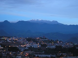
Cauca Department is a department of Southwestern Colombia. Located in the southwestern part of the country, facing the Pacific Ocean to the west, the Valle del Cauca Department to the north, Tolima Department to the northeast, Huila Department to the east, and Nariño Department to the south. Putumayo and Caqueta Departments border the southeast portion of Cauca Department as well. It covers a total area of 29,308 km2 (11,316 sq mi), the 13th largest in Colombia. Its capital is the city of Popayán. The offshore island of Malpelo belongs to the department. It is located in the southwest of the country, mainly in the Andean and Pacific regions plus a tiny part (Piamonte) in the Amazonian region. The area makes up 2.56% of the country.

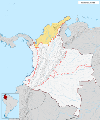
The Caribbean region of Colombia or Caribbean coast region is in the north of Colombia and is mainly composed of 8 departments located contiguous to the Caribbean. It's the second most populated region in the country after Andean Region with approximately 11 million residents according to the Colombian Census 2018. The area covers a total land area of 110,000 km2 (42,000 sq mi), including the Archipelago of San Andrés, Providencia and Santa Catalina in the Caribbean Sea.

Piamonte is a town and municipality in the Cauca Department, Colombia.

The Cordillera Occidental is the lowest in elevation of the three branches of the Colombian Andes. The average altitude is 2,000 m (6,600 ft) and the highest peak is Cerro Tatamá at 4,100 m (13,500 ft). The range extends from south to north dividing from the Colombian Massif in Nariño Department, passes north through Cauca, Valle del Cauca, Risaralda, Chocó, and Caldas Departments to the Paramillo Massif in Antioquia and Córdoba Departments. The cordillera is paralleled on the east by the Cauca river. From this massif the range divides further to form the Serranías de Ayapel, San Jerónimo and Abibe. Only to recede into the Caribbean plain and the Sinú River valley.

The Cordillera Oriental is the widest of the three branches of the Colombian Andes. The range extends from south to north, dividing from the Colombian Massif in Huila Department to Norte de Santander Department where it splits into the Serranía del Perijá and the Cordillera de Mérida in Venezuelan Andes. The highest peak is Ritacuba Blanco at 5,410 m (17,750 ft) in the Sierra Nevada del Cocuy.

The Andean region, located in central Colombia, is the most populated natural region of Colombia. With many mountains, the Andes contain most of the country's urban centers. They were also the location of the most significant pre-Columbian indigenous settlements. Beyond the Colombian Massif in the south-western departments of Cauca and Nariño, the Colombian Andes divide into three branches known as "cordilleras" : the West Andes run adjacent to the Pacific coast and is home to the city of Cali. The Central Andes run up the center of the country between the Cauca and Magdalena river valleys and includes the cities of Medellín, Manizales and Pereira. The East Andes extend northeast towards the Guajira Peninsula, and includes the cities of Bogotá, Bucaramanga and Cúcuta.
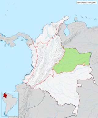
The Orinoquía region is one of the six natural regions of Colombia that belongs to the Orinoco River watershed. It's also known colloquially as the Eastern Plains from the Spanish Llanos Orientales. The region covers most of the area of the departments of Arauca, Casanare, Meta, and Vichada.

The Colombian Massif, also known colloquially as Nudo de Almaguer, refers to a group of mountains within the Andes of south central Colombia. The massif is mainly within the area of the Cauca, Huila, and Nariño Departments. To the south is the Pasto Massif and to the north begins the Central and Eastern Andes.

The contribution of travel and tourism to GDP was US$5,880.3bn in 2016. Tourism generated 556,135 jobs in 2016. Foreign tourist visits were predicted to have risen from 0.6 million in 2007 to 4 million in 2017. Responsible tourism became a peremptory need for Colombia because it minimizes negative social, economic and environmental impacts and makes positive contributions to the conservation of natural and cultural heritage.

The Climate of Colombia is characterized for being tropical and isothermal as a result of its geographical location near the Equator presenting variations within five natural regions and depending on the altitude, temperature, humidity, winds and rainfall. Each region maintains an average temperature throughout the year only presenting variables determined by precipitation during a rainy season caused by the Intertropical Convergence Zone.

Geology of Colombia refers to the geological composition of the Republic of Colombia that determines its geography. Most of the emerged territory of Colombia covers vast areas within the South American Plate, whereas much submerged territory lies within the Caribbean Plate and the Nazca Plate.
The Caribbean region is mostly lowland plains extending from the northern reaches of the Colombian Andes to the Caribbean Sea that are characterized by a variety of ecosystems including: humid forests, dry forests, savannas, wetlands and desert. The Sierra Nevada de Santa Marta rise from the plains to snow-capped peaks, separated from the Andes as an isolated area of high biodiversity and endemism. It contains one of the largest marshes in Colombia, the Ciénaga Grande de Santa Marta. The main river is the Magdalena which is fully navigable in the region and a major path for the flow of shipments to and from inland Colombia.

The Sinú Valley dry forests (NT0229) is an ecoregion in the north of Colombia.

The Magdalena–Urabá moist forests (NT0137) is an ecoregion in the north of Colombia. The terrain is largely flat or undulating, but includes mountainous areas in the south. It contains moist forests and large wetlands that are important to resident and migratory birds. The ecoregion forms a bridge between the Pacific coast ecoregions of Colombia and Central America, and the ecoregions of the Andes and Amazon. It is surrounded by the more populated parts of Colombia and is threatened by farming, ranching, logging, oil exploitation and water pollution in the main rivers.

The Chocó–Darién moist forests (NT0115) is a largely forested, tropical ecoregion of northwestern South America and southern Central America. The ecoregion extends from the eastern Panamanian province of Darién and the indigenous region of Guna Yala to almost the entirety of Colombia's Pacific coast, including the departments of Cauca, Chocó, Nariño and Valle del Cauca.

The Magdalena Valley montane forests (NT0136) is an ecoregion in the Andes mountains of central Colombia.
The Cauca Valley montane forests (NT0109) is an ecoregion in western Colombia. It covers the sides of the Cauca Valley, which runs from south to north between the Central and Western Ranges (cordilleras) of the Colombian Andes. The ecoregion is home to very diverse fauna and flora, due in part to its varied elevations and climates, in part to its position near the isthmus of Panama, the route along which North American species invaded South America and then diversified as they moved to the upper parts of the Andes. Little of the original habitat remains at lower levels, but higher up there are sizeable blocks of forest, some of which are protected.

