Chinchiná is a town and municipality located in the department of Caldas in Colombia, 17 kilometres (11 mi) southwest of Manizales. Founded in 1857 by Antioquian colonists, Chinchiná is settled in a valley surrounded by coffee plantations, called "fincas", in the Central Cordillera of the Andes. Known as Colombia's "coffee heart", the town is home to the Buendía coffee factory and Cenicafé, a coffee research center.
Montenegro is a municipality in the western part of the department of Quindío, Colombia. It is located 10 km west of the departmental capital Armenia. In 2023 it had an estimated population of 38,240.

Santa Fe de Antioquia is a municipality in the Antioquia Department, Colombia. The city is located approximately 58 kilometres (36 mi) north of Medellín, the department capital. The population was 23,216 at the 2018 census.

Jericó is a town, municipality and Catholic bishopric in the Colombian department of Antioquia. It is part of the subregion of Southwestern Antioquia. The distance reference from Medellín city, the capital of the department, is 104 km. It lies 1,910 m above sea level.

Pijao is a municipality in the south-eastern part of the department of Quindío, Colombia. The town is located 31 km south of the departmental capital Armenia in the Colombian coffee growing axis, it's part of the "Coffee Cultural Landscape" UNESCO World Heritage Site in 2011.

Salento is a town and municipality in the north-east of the department of Quindío, Colombia. The municipality covers an area of 377.67 km2. It was the first settlement in Quindío of the modern era, and the first municipality founded in the department. The town of Salento itself is located 24 km northeast of the departmental capital Armenia. In 2023 the municipality of Salento had an estimated population of 9,748.It has a wide variety of tourist attractions including the Cocora Valley where one can find a landscape full of nature, such as the Barranquero or Momotus aequatorialis, a commonly seen bird, take ecological walks and enjoy the landscapes of this town.
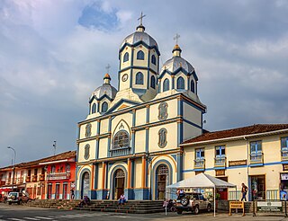
Filandia is a town and municipality in the northern part of the department of Quindío, Colombia. It's located on the west side of Cordillera Central of the Andes mountain range running through central Colombia, 26 km north of the departmental capital Armenia. In 2023 the estimated population of Filandia was 12,596 inhabitants.

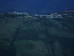
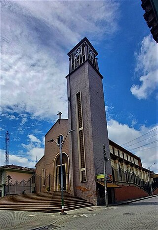
Génova is a municipality in the southern part of the department of Quindío, Colombia. It's located 52 km south of the departmental capital Armenia.
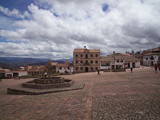
Monguí is a town and municipality in Boyacá Department, Colombia, part of the Sugamuxi Province a subregion of Boyaca.

Mompox or Mompós, officially Santa Cruz de Mompox, is a town and municipality in northern Colombia, in the Bolívar Department. The town initially grew from its proximity to the Magdalena river and has preserved much of its colonial character. It also played an important role in the liberation of South America from Spain. Today, Mompox depends upon tourism, fishing, and some commerce generated by the local cattle raising. The municipality has a population of 46,408 and is adjacent to the municipalities of Pinillos and San Fernando. The historic center of Mompox was made a UNESCO World Heritage Site in 1995, owing to its preserved colonial architecture and mixture of architectural styles.
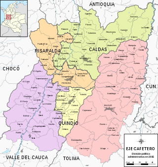
The Colombian coffee region, also known as the Coffee Triangle is a part of the Paisa region in the rural area of Colombia. It is famous for growing and producing the majority of Colombian coffee. There are four departments in the area: Caldas, Quindío, Risaralda and Tolima. The most visited cities are Manizales, Armenia, Pereira, and Ibagué.

Santa Cruz de Lorica is a town and municipality located in the Córdoba Department, northern Colombia.

La Playa or La Playa de Belén is a Colombian municipality in the department of North Santander.
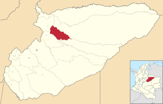
Pore is a town and municipality in the Department of Casanare, Colombia.

Aguadas is a town and municipality in the Colombian department of Caldas. It is bordered to the north by Abejorral, to the east by Sonsón, to the southeast by Salamina, to the south by Pacora, to the west by Caramanta and Valparaiso, and to the northwest by La Pintada. The municipality of Aguadas, located in the northern part of the department, was founded in 1808 by José Narciso Estrada. In addition to the fame of Aguadeño hats, which are very similar to palm-straw Panama hats. Aguadas offers visitors its historic center, which was declared a national monument in 1982. It has a temperate climate thanks to the variety of climates ranging from warm to moor.

Pácora is a town and municipality in the Colombian Department of Caldas. It is located in northern Caldas-Department, on the slopes of the Andes Central Mountains of the Republic of Colombia. With an average annual temperature of 18 °C, the town is bordered to the northeast with Aguadas, Caldas, to the south with Salamina, Caldas and La Merced, and to the west separated by the Cauca River, Marmato-Caldas and Caramanta-Antioquia department. The villages in Pácora are San Bartolomé, Castilla, Las Coles, Los Morros, San Lorenzo and Buenos Aires.

Palestina is a town in the south central region of the state of Caldas, Colombia. Located in the Triangle of Coffee Area, with a culture and tradition related to the colonization of Antioquia and the coffee growing. Because of this, the historic center of the town and surrounding rural areas were named part of the "Coffee Cultural Landscape" UNESCO World Heritage Site in 2011.

Supía is a town and municipality in the Colombian Department of Caldas. Located along the Colombian coffee growing axis, it was part of the "Coffee Cultural Landscape" UNESCO World Heritage Site in 2011.

Villamaría is a town and municipality in the Colombian Department of Caldas. Located in the Colombian coffee growing axis, it was made part of the "Coffee Cultural Landscape" UNESCO World Heritage Site in 2011.

LaRed Turística de Pueblos Patrimonio is an initiative led by Colombia's Ministry of Commerce, Industry, and Tourism, with the assistance of the Ministry of Culture. It is administered by the National Tourism Foundation (FONTUR).