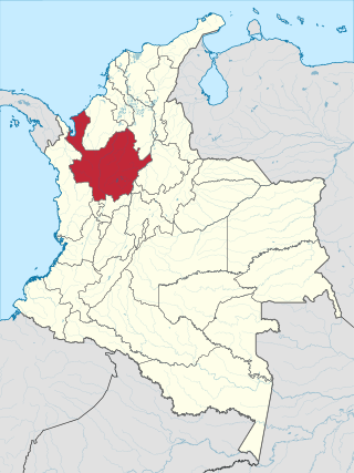
Antioquia is one of the 32 departments of Colombia, located in the central northwestern part of Colombia with a narrow section that borders the Caribbean Sea. Most of its territory is mountainous with some valleys, much of which is part of the Andes mountain range. Antioquia has been part of many territorial divisions of former countries created within the present-day territory of Colombia. Prior to adoption of the Colombian Constitution of 1886, Antioquia State had its own sovereign government.

Departments of Colombia refer to the administrative divisions of Colombia. As of 2024, the unitary republic is made up of thirty-two departments. Each department has a governor and an assembly, elected by popular vote for a four-year period.

Amazonas is a department of Southern Colombia in the south of the country. It is the largest department in area while having the third smallest population among the departments. Its capital is Leticia and its name comes from the Amazon River, which drains the department.
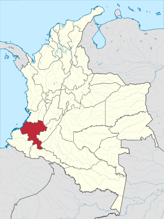
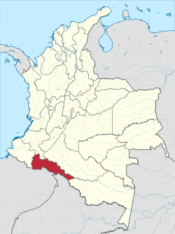
Cauca Department is a department of Southwestern Colombia. Located in the southwestern part of the country, facing the Pacific Ocean to the west, the Valle del Cauca Department to the north, Tolima Department to the northeast, Huila Department to the east, and Nariño Department to the south. Putumayo and Caqueta Departments border the southeast portion of Cauca Department as well. It covers a total area of 29,308 km2 (11,316 sq mi), the 13th largest in Colombia. Its capital is the city of Popayán. The offshore island of Malpelo belongs to the department. It is located in the southwest of the country, mainly in the Andean and Pacific regions plus a tiny part (Piamonte) in the Amazonian region. The area makes up 2.56% of the country.

Guaviare is a department of Colombia. It is in the southern central region of the country. Its capital is San José del Guaviare. Guaviare was created on July 4, 1991, by the new Political Constitution of Colombia. Up until that point, it was a national territory that operated as a commissariat, segregated from territory of the then Commissariat of Vaupés on December 23, 1977.

Meta is a department of Colombia. It is close to the geographic center of the country, to the east of the Andean mountains. A large portion of the department, which is also crossed by the Meta River, is covered by a grassland plain known as the Llanos. Its capital is Villavicencio. The department has a monument placed in the very geographic centre of Colombia, at a place known as Alto de Menegua, a few kilometers from Puerto López.

Nariño is a department of Colombia named after independence leader Antonio Nariño. Its capital is Pasto. It is in the west of the country, bordering Ecuador and the Pacific Ocean.

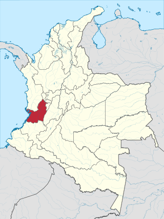
Risaralda is a department of Colombia. It is located in the western central of the country, in the Andean region, It is part of the Coffee axis with Caldas and Quindío. Its capital is Pereira. Risaralda is very well known for the high quality of its coffee, and a booming industry: automotive, clothes, food, trading of goods and services.
Valle del Cauca, or Cauca Valley, is a department in western Colombia abutting the Pacific Ocean. Its capital is Santiago de Cali. Other cities such as Buenaventura, Buga, Cartago, Palmira and Tuluá have great economical, political, social and cultural influence on the department's life. Valle del Cauca has the largest number of independent towns with over 100,000 inhabitants in the country, counting six within its borders. Buenaventura has the largest and busiest seaport in Colombia, moving about 8,500,000 tons of merchandise annually.

Vaupés is a department of Southeastern Colombia in the jungle covered Amazonía Region. It is located in the southeast part of the country, bordering Brazil to the east, the department of Amazonas to the south, Caquetá to the west, and Guaviare, and Guainía to the north; covering a total area of 54,135 km2. Its capital is the town of Mitú. As of 2018, the population was 40,797, making it the least populous department in Colombia.

Popayán is the capital of the Colombian department of Cauca. It is located in the Pubenza Valley in southwestern Colombia between the Western Mountain Range and Central Mountain Range. The municipality has a population of 318,059, an area of 483 km2, is located 1760 meters above sea level, and has an average temperature of 18 °C.

Inírida, formerly Puerto Inírida, is the capital city, and a municipality, of the department of Guainía in Colombia. It was established in 1963 on the site of the small village of Obando, at the time in the municipality of San Felipe. The municipality was renamed in 1974. The municipal population of 31,514 is mostly indigenous and accounts for about a third of the department's population.

The Ecuadorian–Peruvian territorial dispute was a territorial dispute between Ecuador and Peru, which, until 1928, also included Colombia. The dispute had its origins on each country's interpretation of what Real Cedulas Spain used to precisely define its colonial territories in the Americas. After independence, all of Spain's colonial territories signed and agreed to proclaim their limits in the basis of the principle of uti possidetis juris, which regarded the Spanish borders of 1810 as the borders of the new republics. However, conflicting claims and disagreements between the newly formed countries eventually escalated to the point of armed conflicts on several occasions.

Caquetá Department is a department of Colombia. Located in the Amazonas region, Caquetá borders with the departments of Cauca and Huila to the west, the department of Meta to the north, the department of Guaviare to the northeast, the department of Vaupés to the east, the departments of Amazonas and Putumayo to the south covering a total area of 88,965 km², the third largest in the country. Its capital is the city of Florencia.

The Real Audiencia of Quito was an administrative unit in the Spanish Empire which had political, military, and religious jurisdiction over territories that today include Ecuador, parts of northern Peru, parts of southern Colombia and parts of northern Brazil. It was created by Royal Decree on 29 August 1563 by Philip II of Spain in the city of Guadalajara. It ended in 1822 with the incorporation of the area into the Republic of Gran Colombia.

The Oriente is a region of eastern Ecuador, comprising the eastern slopes of the Ecuadorian Andes and the lowland areas of rainforest in the Amazon basin.
The Andaquí are an indigenous people of Colombia, who live in the Upper Caquetá River Basin, the Fragua Valley of Cauca Department, and the Suaza Valley of southwest Huila Department.
Margarita Diez-Colunje y Pombo was a Colombian historian, translator, and genealogist.

The Colombian–Peruvian territorial dispute was a territorial dispute between Colombia and Peru, which, until 1916, also included Ecuador. The dispute had its origins on each country's interpretation of what Real Cedulas Spain used to precisely define its possessions in the Americas. After independence, all of Spain's former territories signed and agreed to proclaim their limits in the basis of the principle of uti possidetis juris, which regarded the Spanish borders of 1810 as the borders of the new republics. However, conflicting claims and disagreements between the newly formed countries eventually escalated to the point of armed conflicts on several occasions.
The South American territorial disputes are the territorial disputes and litigations that have developed in South America since the aftermath of the continent's wars of independence, which have shaped the current political geography of the region. These conflicts have been resolved through both military and diplomatic means. The most recent conflict in the Americas of this nature was the Cenepa War in 1995, between Ecuador and Peru.