The Orinoco is one of the longest rivers in South America at 2,140 km (1,330 mi). Its drainage basin, sometimes known as the Orinoquia, covers ca 1 million km2, with 65% of it in Venezuela and the 35% in Colombia. It is the fourth largest river in the world by discharge volume of water. The nevertheless high volume flow of the Orinoco can be explained by the high precipitation in almost the entire catchment area. The Orinoco River and its tributaries are the major transportation system for eastern and interior Venezuela and the Llanos of Colombia. The environment and wildlife in the Orinoco's basin are extremely diverse.

Boyacá is one of the thirty-two departments of Colombia, and the remnant of Boyacá State, one of the original nine states of the "United States of Colombia".

Arauca is a department of Eastern Colombia located in the extreme north of the Orinoco Basin of Colombia, bordering Venezuela. The southern boundary of Arauca is formed by the Casanare and Meta Rivers, separating Arauca from the departments of Casanare and Vichada. To the west, Arauca borders the department of Boyacá. The Caño Limón oil fields located within Arauca account for almost a third of the Colombian oil output. Its capital is the town of Arauca.

Guainía is a department of Eastern Colombia. It is in the east of the country, bordering Venezuela and Brazil. Its capital is Inírida. In 1963 Guainía was split off from Vaupés department. The northern part and the Inírida River are included in the Orinoco basin; the rest is part of the Amazon basin. The Guaviare River is the main area of colonization; many colonos come from the Colombian Andean zone, most of them from Boyacá. They are followed by the llaneros, people from the Eastern plains (Llanos). The population is mainly composed of Amerindians, and the largest ethnic groups are the Puinaves and the curripacos. There are a total of 24 ethnic groups in the department; many of them speak four Indigenous languages besides Spanish and Portuguese.

Meta is a department of Colombia. It is close to the geographic center of the country, to the east of the Andean mountains. A large portion of the department, which is also crossed by the Meta River, is covered by a grassland plain known as the Llanos. Its capital is Villavicencio. The department has a monument placed in the very geographic centre of Colombia, at a place known as Alto de Menegua, a few kilometers from Puerto López.

Vaupés is a department of Southeastern Colombia in the jungle covered Amazonía Region. It is located in the southeast part of the country, bordering Brazil to the east, the department of Amazonas to the south, Caquetá to the west, and Guaviare, and Guainía to the north; covering a total area of 54,135 km2. Its capital is the town of Mitú. As of 2018, the population was 40,797, making it the least populous department in Colombia.

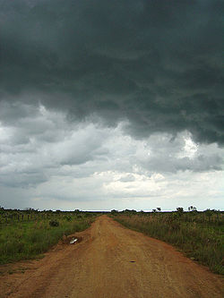
The Llanos is a vast tropical grassland plain situated to the east of the Andes in Colombia and Venezuela, in northwestern South America. It is an ecoregion of the tropical and subtropical grasslands, savannas, and shrublands biome.

Puerto Carreño, translation English: Puerto Carreno, lit. 'Port Carreno' is the departmental capital city, and a municipality combined of the department of Vichada in the Llanos of Colombia located on the Orinoco River. Puerto Carreño is best-known as a tourist gateway to hundreds of adventure, ecological and sustainable tourism destinations, it is well-known for peacock bass fishing on the Vita River, Indigenous artisans from the Orinoquia, as a river port trade center, and as a frontier settlement that has become the capital of the second largest department (province) in Colombia.

The Meta River is a major left tributary of the Orinoco River in eastern Colombia and southern Venezuela, South America. The Meta originates in the Eastern Ranges of the Andes and flows through the Meta Department, Colombia as the confluence of the Humea, Guatiquía and Guayuriba rivers. It flows east-northeastward across the Llanos Orientales of Colombia following the direction of the Meta Fault. The Meta forms the northern boundary of Vichada Department, first with Casanare Department, then with Arauca Department, and finally with Venezuela, down to Puerto Carreño where it flows into the Orinoco.
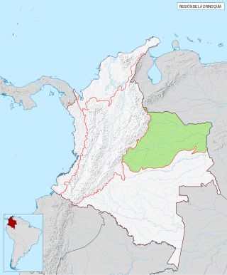
The Orinoquía region is one of the six natural regions of Colombia that belongs to the Orinoco River watershed. It's also known colloquially as the Eastern Plains from the Spanish Llanos Orientales. The region covers most of the area of the departments of Arauca, Casanare, Meta, and Vichada.

The Guahibo people are an indigenous people native to the Llanos or savanna plains in eastern Colombia and in southern Venezuela near the Colombian border. Their population was estimated at 23,772 people in 1998.

Caquetá Department is a department of Colombia. Located in the Amazonas region, Caquetá borders with the departments of Cauca and Huila to the west, the department of Meta to the north, the department of Guaviare to the northeast, the department of Vaupés to the east, the departments of Amazonas and Putumayo to the south covering a total area of 88,965 km², the third largest in the country. Its capital is the city of Florencia.

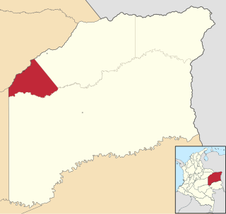
Cumaribo is a town and municipality located in the Department of Vichada, Republic of Colombia. Cumaribo was founded by Jose Nicolino Mattar in 1959.
La Primavera is a town and municipality located in the Department of Vichada, Colombia.
Santa Rosalía is a town and municipality located in the Department of Vichada, Colombia.

Because of its natural structure, Colombia can be divided into six distinct natural regions. These consist of the Andean Region, covering the three branches of the Andes mountains found in Colombia; the Caribbean Region, covering the area adjacent to the Caribbean Sea; the Pacific Region adjacent to the Pacific Ocean; the Orinoquía Region, part of the Llanos plains mainly in the Orinoco river basin along the border with Venezuela; the Amazon Region, part of the Amazon rainforest; and finally the Insular Region, comprising the islands in both the Atlantic and Pacific Oceans. Colombia is located in South America.
Canal Trece is a Colombian free-to-air television network with regional coverage, specialized in cultural programming. Being a public television station, it is owned by the Colombian Government and its operations are managed by the RTVC Public Media System. The headquarters of the channel are located in Bogotá.

The Llanos Basin or Eastern Llanos Basin is a major sedimentary basin of 96,000 square kilometres (37,000 sq mi) in northeastern Colombia. The onshore foreland on Mesozoic rift basin covers the departments of Arauca, Casanare and Meta and parts of eastern Boyacá and Cundinamarca, western Guainía, northern Guaviare and southeasternmost Norte de Santander. The northern boundary is formed by the border with Venezuela, where the basin grades into the Barinas-Apure Basin.