The Muisca are an indigenous people and culture of the Altiplano Cundiboyacense, Colombia, that formed the Muisca Confederation before the Spanish conquest. The people spoke Muysccubun, a language of the Chibchan language family, also called Muysca and Mosca. They were encountered by conquistadors dispatched by the Spanish Empire in 1537 at the time of the conquest. Subgroupings of the Muisca were mostly identified by their allegiances to three great rulers: the hoa, centered in Hunza, ruling a territory roughly covering modern southern and northeastern Boyacá and southern Santander; the psihipqua, centered in Muyquytá and encompassing most of modern Cundinamarca, the western Llanos; and the iraca, religious ruler of Suamox and modern northeastern Boyacá and southwestern Santander.

Simijaca is a town and municipality in the Ubaté Province, part of the Cundinamarca Department, Colombia. The town centre is located at an altitude of 2,559 metres (8,396 ft) on the Altiplano Cundiboyacense at 136 kilometres (85 mi) from the capital Bogotá. Simijaca borders the Boyacá municipalities Chiquinquirá and Caldas in the north, Susa and Carmen de Carupa in the south, Caldas in the west and San Miguel de Sema in the east.

San Miguel de Sema is a town and municipality in Boyacá Department, Colombia, part of the subregion of the Western Boyacá Province. It is one of the 123 municipalities of the department of Boyacá, Colombia, located to the west of the department with the urban centre at an altitude of 2,615 metres (8,579 ft). It is bordered by the municipalities Chiquinquirá, Simijaca, Fúquene (Cundinamarca), and the Boyacá municipalities Ráquira and Tinjacá.

Cucaita is a municipality in the Central Boyacá Province, part of Boyacá Department, Colombia. The urban centre is situated on the Altiplano Cundiboyacense at a distance of 20 kilometres (12 mi) from the department capital Tunja. Cucaita borders Sora in the north, Tunja in the east and south and Samacá in the south and west.
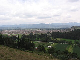
Ubaté is a town and municipality in the Ubaté Province, part of Cundinamarca Department, Colombia. Ubaté is the capital of the province with the same name and situated in the Ubaté–Chiquinquirá Valley of the Altiplano Cundiboyacense. The urban centre is located at an altitude of 2,556 metres (8,386 ft) and 97 kilometres (60 mi) from the capital Bogotá. The province borders the department of Boyacá in the north, the Rionegro Province in the west, the Central Savanna Province in the south and in the east and southeast the Almeidas Province.
Ventaquemada is a town and municipality in the Central Boyacá Province, part of the Colombian department of Boyacá. Ventaquemada is located at a distance of 98 kilometres (61 mi) from the capital Bogotá and 29 kilometres (18 mi) from the departmental capital Tunja. The urban centre is situated at an altitude of 2,630 metres (8,630 ft) on the Altiplano Cundiboyacense in the Eastern Ranges of the Colombian Andes. Ventaquemada borders Tunja and Samacá in the north, Boyacá, Boyacá, Jenesano and Nuevo Colón in the east, Turmequé and Villapinzón in the south and Guachetá, Lenguazaque and Villapinzón in the west.

Guateque is a town and municipality in the Colombian Department of Boyacá, part of the subregion of the Eastern Boyacá Province. Guateque's urban center is located at an altitude of 1,815 metres (5,955 ft) on the Altiplano Cundiboyacense at distances of 125 kilometres (78 mi) from the department capital Tunja and 112 kilometres (70 mi) from Bogotá, capital of Colombia. It borders the municipalities of La Capilla, Tenza, Sutatenza, Somondoco of Boyacá and Tibiritá and Manta of Cundinamarca.

Jenesano is a town and municipality in the Márquez Province, part of the Colombian Department of Boyacá. The urban centre is located at an altitude of 2,100 metres (6,900 ft) on the Altiplano Cundiboyacense. Jenesano borders Nuevo Colón in the west, Ramiriquí in the east, Boyacá, Boyacá in the north and Tibaná in the south.
Cuítiva is a town and municipality in the Sugamuxi Province, part of the Colombian department of Boyacá. The urban centre is situated on the Altiplano Cundiboyacense at an altitude of 2,750 metres (9,020 ft) and a distance of 85 kilometres (53 mi) from the department capital Tunja. The altitudes of the municipality range from 2,727 metres (8,947 ft) to 3,200 metres (10,500 ft) and it borders Iza in the north, Sogamoso in the east, Aquitania in the west and Tota in the south.
Bojacá is a municipality and town of the Western Savanna Province, Colombia in the department of Cundinamarca. The urban centre is situated at an altitude of 2,598 metres (8,524 ft) on the Bogotá savanna at 40 kilometres (25 mi) from the capital Bogotá. The municipality borders Zipacón, Madrid and Facatativá in the north, Madrid and Mosquera in the east, Soacha and San Antonio del Tequendama in the south and Tena, La Mesa and Zipacón in the west.

Funza is a municipality and town of Colombia in the Western Savanna Province, of the department of Cundinamarca. Funza is situated on the Bogotá savanna, the southwestern part of the Altiplano Cundiboyacense with the urban centre at an altitude of 2,548 metres (8,360 ft). In Funza the La Florida wetland, part of the wetlands of Bogotá, a remnant of the Pleistocene Lake Humboldt, still exists. The town is part of the Metropolitan Area of Bogotá and borders Madrid and Tenjo in the north, Mosquera in the south, Madrid in the west and Cota and the locality Engativá of the capital Bogotá in the east. The eastern boundary is formed by the Bogotá River. Funza is the site of the former main settlement Bacatá of the Muisca Confederation. Modern Funza was founded by Gonzalo Jiménez de Quesada during the Spanish conquest of the Muisca on April 20, 1537.

Gachancipá is a municipality and town of Colombia in the Central Savanna Province, part of the department of Cundinamarca. The urban centre is located on the Altiplano Cundiboyacense at 42 kilometres (26 mi) from the capital Bogotá. The municipality borders Guatavita and Tocancipá in the south, Sesquilé and Guatavita in the east, Nemocón in the west and Suesca in the north.

Gachetá is a municipality and town of Colombia, capital of the Guavio Province, part of the department of Cundinamarca. The urban centre of Gachetá is situated at an altitude of 1,745 metres (5,725 ft) in the Eastern Ranges of the Colombian Andes. The municipality borders Machetá and Manta in the north, the department of Boyacá and Ubalá in the east, Gama and Junín in the south and Guatavita in the west.
Guachetá is a municipality and town of Colombia in the Ubaté Province of the department of Cundinamarca. Guachetá is located at 118 kilometres (73 mi) from the capital Bogotá. It borders the Boyacá municipalities of Ráquira and Samacá in the north, Ubaté and Lenguazaque in the south, Ventaquemada and Lenguazaque in the east and in the west Fúquene and Ubaté. Guachetá is located on the Altiplano Cundiboyacense at altitudes between 2,600 metres (8,500 ft) and 3,500 metres (11,500 ft).

Junín is a municipality and town of Colombia in the Guavio Province, part of the department of Cundinamarca. The urban centre is situated at an altitude of 2,300 metres (7,500 ft) in the east of the Altiplano Cundiboyacense. Junín borders Gachetá and Guatavita in the north, Gama and Gachalá in the east, Fómeque in the south, and La Calera and Guasca in the west.

Lenguazaque is a municipality and town of Colombia in the department of Cundinamarca. Lenguazaque is situated on the Altiplano Cundiboyacense, part of the Eastern Ranges of the Colombian Andes at a distance of 116 kilometres (72 mi) from the capital Bogotá. It borders Guachetá in the north, Ubaté in the west, Cucunubá in the south and Villapinzón in the east.

Pacho is a municipality and town of Colombia in the department of Cundinamarca. Pacho is part of the Rionegro Province and the urban centre is situated at a distance of 88 kilometres (55 mi) from the capital Bogotá at an altitude of 2,136 metres (7,008 ft), while the altitude ranges from 1,000 metres (3,300 ft) to 3,700 metres (12,100 ft). The municipality borders San Cayetano, Villagómez and Topaipí in the north, Supatá and Subachoque in the south, Vergara and El Peñón in the west and in the east Zipaquirá, Tausa and Cogua.

Susa is a town and municipality in the Ubaté Province, part of the Cundinamarca Department, Colombia. The town centre is located at an altitude of 2,655 metres (8,711 ft) on the Altiplano Cundiboyacense at 130 kilometres (81 mi) from the capital Bogotá. Susa borders Simijaca, Fúquene, San Miguel de Sema and Lake Fúquene.

Sutatausa is a municipality and town of Colombia in the Ubaté Province, part of the department of Cundinamarca. The municipality is located on the Altiplano Cundiboyacense at a distance of 88 kilometres (55 mi) from the capital Bogotá and borders Ubaté in the north, Tausa in the south, Cucunubá in the east and Carmen de Carupa and Tausa in the west.
Tausa is a municipality and town of Colombia in the Ubaté Province, part of the department of Cundinamarca. Tausa is and was an important town on the Altiplano Cundiboyacense due to its salt mine. It was the third most prolific salt deposit for the original inhabitants of the area; the Muisca. Tausa's urban centre is located at an elevation of 2,950 metres (9,680 ft) and a distance of 65 kilometres (40 mi) from the capital Bogotá. The municipality borders San Cayetano, Carmen de Carupa and Sutatausa in the north, Pacho in the west, Sutatausa, Cucunubá and Suesca in the east and in the south with Nemocón and Cogua.