Líbano, Tolima

Last updated • 3 min readFrom Wikipedia, The Free Encyclopedia
Líbano, Tolima
Libano Tolima- camilogaleano(.)com.jpg
Panoramic photo of Líbano.
Flag of Libano (Tolima).svg
Seal of Libano, Tolima.png
Colombia - Tolima - Libano.svg
Location of the municipality and town of Líbano, Tolima in the Tolima Department of Colombia.
Coordinates: 4°55′N75°10′W / 4.917°N 75.167°W / 4.917; -75.167
CountryFlag of Colombia.svg  Colombia
Department Tolima Department
Government
  Alcalde (Mayor)José Germán Castellanos Herrera
Area
   Municipality 282.4 km2 (109.0 sq mi)
  Urban
3.64 km2 (1.41 sq mi)
Elevation
1,565 m (5,135 ft)
Population
 (2020 est.) [1]
   Municipality 36,231
  Density130/km2 (330/sq mi)
   Urban
23,290
  Urban density6,400/km2 (17,000/sq mi)
Time zone UTC-5 (Colombia Standard Time)
Website http://www.libano-tolima.gov.co

Líbano is a town and municipality in the Tolima department of Colombia. The population of the municipality was estimated at 36,231 as of 2020. [1] Along with Honda, Líbano is the seat of the Roman Catholic Diocese of Líbano–Honda.

Contents

History

Before the arrival of Europeans, the Panches, Pantagoras, Bledos, and Marquetones lived in the region. They were among the tribes most feared by the Muisca. Their society was an aristocratic hierarchy headed by a chief.

By the mid-nineteenth century, settlers from Antioquia explored south in search of vacant land, and mines, to be acquired by degrees of effort and incorporated into the national economy. A caravan of Antioqueños led by Isidro Parra, found a valley planted with cedars and oaks, and constructed a few huts. The hamlet was named Líbano, the Spanish word for Lebanon.

The layout of the built-up area of Líbano was organized as a village in 1886. Since 1900, Líbano developed as an important village, pushing dirt roads in all directions. Socio-economic development of the region was guided by its founders from the development of mining and power to the cultivation of coffee, which has become the main characteristic element of the economy, society and culture of the area.

The city of Líbano is the see of the Diocese of Líbano-Honda, created by Pope John Paul II on July 26, 1989, by the Bull "Ita Iam." The territorial area of the diocese covers an area of 3,477 km ² with approximately 240,000 inhabitants. Its first bishop was Monsignor José Luis Serna Alzate, who took office on October 7, 1989. On 5 December 2015, José Luis Henao Cadavid was installed as the fourth bishop of the diocese.

Geography

Aerial view of Libano with Nevado del Tolima in the background. Libano (Tolima) Colombia 2a.jpg
Aerial view of Líbano with Nevado del Tolima in the background.

The municipality of Líbano is located in the north of the department of Tolima, about 56 kilometres (35 mi) north of Ibagué, the departmental capital. Líbano is bordered to the north by the municipalities of Armero and Villahermosa, to the West by the municipality of Murillo, to the East by the municipality of Lérida and to the south by Santa Isabel and Venadillo.

Líbano is located in the Cordillera Central, east of Nevado del Ruiz. The town is at an altitude of 1,565 metres (5,135 ft) above sea level, putting it in the tierra templada, or temperate zone, of Colombia. The area is hilly and heavily forested where it is not used for agriculture. Agriculture in the area includes growing of coffee, bananas, plantains, and beans.

History

El Libano is a historic coffee producing municipality in Tolima. There, there are 77 villages and 3,980 families that make their living by planting coffee.

His production has also been recognized in various competitions such as the Master of Coffee Colombia, where the farmer Ómar Arango was recognized for the high quality of his coffee in 2019.

Also, the specialty coffees that come out of this municipality are exported to countries such as China, Japan, Korea, the United States, Spain, and England, among others.

In addition, it could be said that this is the municipality with the longest coffee history in Tolima, In the 1900s it had threshing machines that were headquarters of important companies in Europe, they were called “threshers”.

Notable people

Climate

Climate data for Líbano (Trinidad La), elevation 1,430 m (4,690 ft), (1971–2000)
MonthJanFebMarAprMayJunJulAugSepOctNovDecYear
Mean daily maximum °C (°F)24.3
(75.7)
24.4
(75.9)
24.6
(76.3)
23.9
(75.0)
23.7
(74.7)
24.0
(75.2)
24.8
(76.6)
25.3
(77.5)
24.8
(76.6)
23.6
(74.5)
23.8
(74.8)
23.9
(75.0)
24.3
(75.7)
Daily mean °C (°F)19.8
(67.6)
19.9
(67.8)
20.2
(68.4)
20.0
(68.0)
20.0
(68.0)
19.9
(67.8)
20.1
(68.2)
20.4
(68.7)
20.1
(68.2)
19.5
(67.1)
19.6
(67.3)
19.6
(67.3)
19.9
(67.8)
Mean daily minimum °C (°F)16.0
(60.8)
16.2
(61.2)
16.5
(61.7)
16.6
(61.9)
16.5
(61.7)
16.0
(60.8)
15.4
(59.7)
15.6
(60.1)
15.9
(60.6)
16.1
(61.0)
16.2
(61.2)
15.9
(60.6)
16.1
(61.0)
Average precipitation mm (inches)120.4
(4.74)
129.0
(5.08)
180.1
(7.09)
244.1
(9.61)
260.9
(10.27)
133.6
(5.26)
82.6
(3.25)
117.7
(4.63)
227.1
(8.94)
292.0
(11.50)
205.0
(8.07)
128.3
(5.05)
2,120.8
(83.50)
Average precipitation days131518222014111317232016202
Average relative humidity (%)83828286878275737986878582
Mean monthly sunshine hours 139.5104.6105.493.0111.6147.0186.0186.0153.0105.4105.0124.01,560.5
Mean daily sunshine hours 4.53.73.43.13.64.96.06.05.13.43.54.04.3
Source: Instituto de Hidrologia Meteorologia y Estudios Ambientales [2]

Related Research Articles

<span class="mw-page-title-main">Cauca Department</span> Department of Colombia

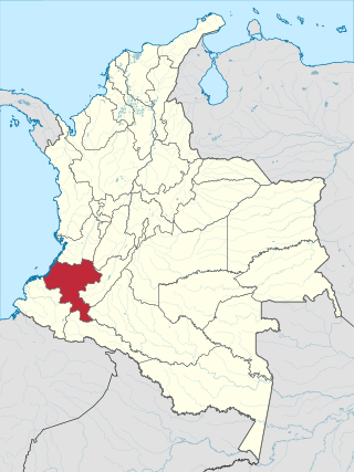
Cauca Department is a department of Southwestern Colombia. Located in the southwestern part of the country, facing the Pacific Ocean to the west, the Valle del Cauca Department to the north, Tolima Department to the northeast, Huila Department to the east, and Nariño Department to the south. Putumayo and Caqueta Departments border the southeast portion of Cauca Department as well. It covers a total area of 29,308 km2 (11,316 sq mi), the 13th largest in Colombia. Its capital is the city of Popayán. The offshore island of Malpelo belongs to the department. It is located in the southwest of the country, mainly in the Andean and Pacific regions plus a tiny part (Piamonte) in the Amazonian region. The area makes up 2.56% of the country.

<span class="mw-page-title-main">Ibagué</span> Municipio in Andean Region, Colombia

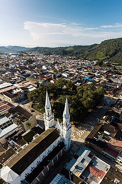
Ibagué is the capital of Tolima, one of the 32 departments that make up the Republic of Colombia. The city is located in the center of the country, on the central mountain range of the Colombian Andes, near Nevado del Tolima. It is one of the most populous cities in the country, with a population of 492,554, making it the eleventh most populous in Colombia, and with a population of 529,625 in the municipality. It was founded on 14 October 1550, by the Spanish captain Andrés López de Galarza. The city of Ibagué is divided into 13 communes and the rural area has 17 corregimientos. As the capital of the department of Tolima the city hosts the Government of Tolima, the Departmental Assembly, and the Attorney General's Office. It is the main epicenter of political, economic, administrative, business, art, culture, and tourism activities in the area.

<span class="mw-page-title-main">Honda, Tolima</span> Municipality and town in Tolima, Colombia

Honda is a town and municipality in the Tolima department of Colombia. The population of the municipality was 24,693 as of the census 2018. Along with Líbano, Honda is the seat of the Roman Catholic Diocese of Líbano-Honda. The main industries of Honda are tourism, fishing, and cattle-ranching.

<span class="mw-page-title-main">Natagaima</span> Municipality and town in Tolima Department, Colombia

Natagaima is a town and municipality in the Tolima department of Colombia, on the shore of the Magdalena River, at 326 meters (1,070 ft) above sea level. The population of the municipality was 21,324 as of the 1993 census, and its average temperature is 26 °C (79 °F). Natagaima was founded in 1606 by Spanish conqueror Juan de Borja y Armendia.

<span class="mw-page-title-main">Villahermosa, Tolima</span> Municipality and town in Tolima Department, Colombia

Villahermosa is a town and municipality in the Tolima department of Colombia. The population of the municipality was 12,574 as of the 1993 census. The municipality is also one of the most important coffee producers of Tolima's north.

<span class="mw-page-title-main">Sonsón</span> Municipality and town in Antioquia Department, Colombia

Sonsón is a municipality in the Colombian department of Antioquia. Sonsón is located in Eastern Antioquia. It is one of the seats of the Roman Catholic Diocese of Sonsón–Rionegro. Sonsón celebrates "Las Fiestas Del Maíz"- during the month of August, being the most traditional, historical and representative festival in western Colombia. The population was estimated to be 33,598 in 2020.

<span class="mw-page-title-main">Pijao, Quindío</span> Municipality and town in Quindío Department, Colombia

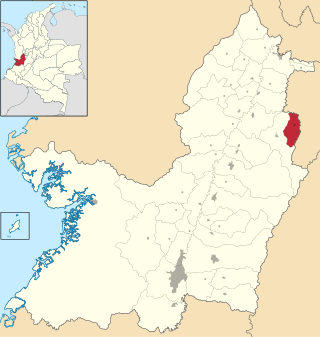
Pijao is a municipality in the south-eastern part of the department of Quindío, Colombia. The town is located 31 km south of the departmental capital Armenia in the Colombian coffee growing axis, it's part of the "Coffee Cultural Landscape" UNESCO World Heritage Site in 2011.

<span class="mw-page-title-main">Calarcá</span> Municipality and town in Quindío Department, Colombia

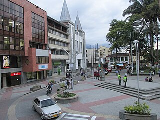
Calarcá is a municipality in the eastern part of the department of Quindío, Colombia. It is located 4 km east of the departmental capital Armenia. Its nickname is La Villa del Cacique in homage of its writers. The city was founded in 1886 by Segundo Henao during the time of colonization by people from Antioquia. It is the second most populated city in Quindío, after Armenia.

<span class="mw-page-title-main">Colombian coffee growing axis</span> Region of Colombia known for growing coffee

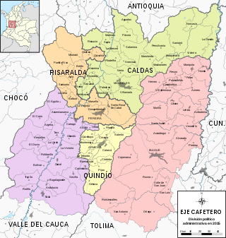
The Colombian coffee region, also known as the Coffee Triangle is a part of the Paisa region in the rural area of Colombia. It is famous for growing and producing the majority of Colombian coffee. There are four departments in the area: Caldas, Quindío, Risaralda and Tolima. The most visited cities are Manizales, Armenia, Pereira, and Ibagué.

<span class="mw-page-title-main">Aguachica</span> Municipality and city in Caribbean, Colombia

Aguachica, is a small city and municipality in the southern region of the Cesar Department, Colombia. There is no historical support on the date of its foundation; however, August 16, 1748 has been chosen by the community. Saint Roch is the patron saint of the municipality and August 16 is the date on which the Catholic Church celebrates its festival.

<span class="mw-page-title-main">Agustín Codazzi, Cesar</span> Municipality and town in Caribbean, Colombia

Agustín Codazzi, or Codazzi, is a city and municipality of the Department of Cesar in Colombia. It was founded in 1784 by the Spanish Captain Salvador Felix de Arias with the name of El Pueblito del Espiritu Santo but later renamed after the Italian cartographer, Giovanni Battista Agostino Codazzi, who died in this place in 1859. It is located along the Serranía del Perijá, covering some of the area pertaining to the valley of the Cesar River.

<span class="mw-page-title-main">Tolima Department</span> Department of Colombia

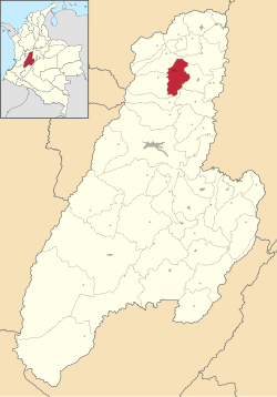
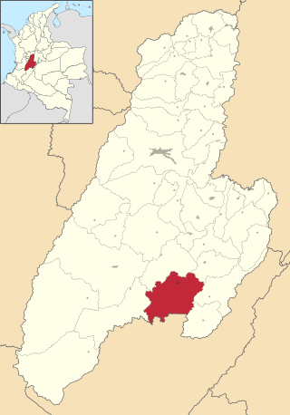
Tolima is one of the 32 departments of Colombia, located in the Andean region, in the center-west of the country. It is bordered on the north and the west by the department of Caldas; on the east by the department of Cundinamarca; on the south by the department of Huila, and on the west by the departments of Cauca, Valle del Cauca, Quindío and Risaralda. Tolima has a surface area of 23,562 km2, and its capital is Ibagué. The department of Tolima was created in 1861 from a part of what was previously Cundinamarca.

<span class="mw-page-title-main">La Plata, Huila</span> Municipality and town in Huila Department, Colombia

La Plata is a town and municipality in the Huila Department, Colombia, with a municipal population of 61,026 including the rural area, situated at an altitude of 1,050 m. It is located 122 km away from Neiva, 147 km from the city of Popayán and 210 km from the town of San Agustín.

<span class="mw-page-title-main">Caicedonia</span> Municipality and town in Valle del Cauca Department, Colombia

Caicedonia is a town and municipality located in the Department of Valle del Cauca, Colombia, situated about 172 km from the capital Cali. Founded in 1910 by Daniel Gutierrez, Juan Bautista Angely and a group of settlers from Antioquia, Caldas, and Tolima, it was named after Lisandro Caicedo and became a municipality in 1923. Mostly mountainous, its economy is based on agriculture and commerce, its main exports are corn, coffee, sugarcane and bananas. Given its location on the border with the Quindío Department, only 35 km from that department's capital, Armenia, Caicedonia belongs ethnographically and culturally to the Paisa region.

<span class="mw-page-title-main">Roman Catholic Archdiocese of Ibagué</span> Catholic archdiocese in Colombia

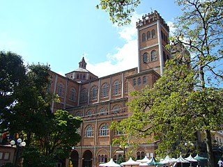
The Roman Catholic Archdiocese of Ibagué is an archdiocese located in the city of Ibagué in Colombia.

<span class="mw-page-title-main">Roman Catholic Archdiocese of Florencia</span> Catholic archdiocese in Colombia

The Roman Catholic Archdiocese of Florencia is an archdiocese located in the city of Florencia, Caquetá in Colombia.

<span class="mw-page-title-main">Roman Catholic Diocese of Líbano–Honda</span> Diocese of the Catholic Church in Colombia

The Roman Catholic Diocese of Líbano–Honda is a diocese located in northern Tolima Department in Colombia, with sees in the cities of Líbano and Honda in the ecclesiastical province of Ibagué in Colombia.

<span class="mw-page-title-main">Roman Catholic Diocese of Jericó</span> Latin Catholic ecclesiastical territory in Colombia

The Diocese of Jericó is a Latin Church ecclesiastical territory or diocese of the Catholic Church in Western Colombia. It is a suffragan diocese in the ecclesiastical province of the metropolitan Archdiocese of Medellín.

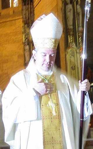
José Luis Serna Alzate was a Catholic Church bishop.

<span class="mw-page-title-main">José Miguel Gómez Rodríguez</span>

José Miguel Gómez Rodríguez is a Roman Catholic clergyman and metropolitan archbishop of Manizales.

References

  1. 1 2 Citypopulation.de
  2. "Promedios Climatológicos 1971–2000" (in Spanish). Instituto de Hidrologia Meteorologia y Estudios Ambientales. Retrieved 25 June 2024.[ dead link ]

4°55′N75°10′W / 4.917°N 75.167°W / 4.917; -75.167