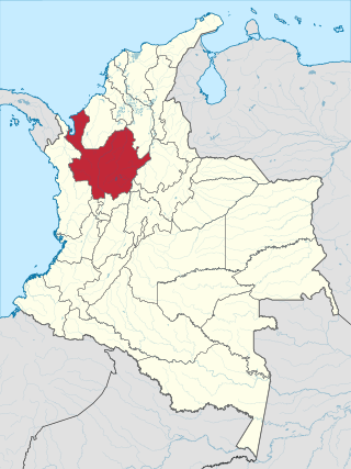
Antioquia is one of the 32 departments of Colombia, located in the central northwestern part of Colombia with a narrow section that borders the Caribbean Sea. Most of its territory is mountainous with some valleys, much of which is part of the Andes mountain range. Antioquia has been part of many territorial divisions of former countries created within the present-day territory of Colombia. Prior to adoption of the Colombian Constitution of 1886, Antioquia State had its own sovereign government.

Medellín, officially the Special District of Science, Technology and Innovation of Medellín, is the second-largest city in Colombia after Bogotá, and the capital of the department of Antioquia. It is located in the Aburrá Valley, a central region of the Andes Mountains, in northwestern South America. The city's population was 2,508,452 at the 2018 census. The metro area of Medellín is the second-largest urban agglomeration in Colombia in terms of population and economy, with more than 4 million people.

Luis Mariano Ospina Pérez, commonly known as Mariano Ospina Pérez, was a Colombian politician and a member of the Colombian Conservative Party. He served as the 17th President of Colombia between 1946 and 1950.
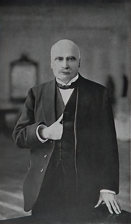
Marco Fidel Suárez was a Colombian political figure. He served as president of Colombia from 1918 to 1921. He was born on April 23, 1855, in the town of Hatoviejo, Antioquia. His parents were Rosalía Suárez and José María Barrientos.

A Paisa is someone from a region in the northwest of Colombia, including part of the West and Central cordilleras of the Andes in Colombia. The Paisa region is formed by the departments of Antioquia, Caldas, Risaralda and Quindío. Some regions of Valle del Cauca Department (north) and Tolima Department (west) culturally identify as paisas. The main cities of the Paisa region are Medellín, Pereira, Manizales and Armenia.

Santa Fe de Antioquia is a municipality in the Antioquia Department, Colombia. The city is located approximately 58 kilometres (36 mi) north of Medellín, the department capital. The population was 23,216 at the 2018 census.

Carepa is a town and municipality in Antioquia Department, Colombia. Carepa is part of the Urabá Antioquia sub-region.

Caucasia is a municipality located in the subregion of Bajo Cauca Antioquia department, in Colombia. Bounded on the south by the department of Córdoba, in the east by the municipalities of Antioquia in Nechí and El Bagre, on the north by the municipality of Zaragoza, and west to the town of Cáceres, and is located 270 km from Medellín.

Puerto Berrío is a municipality and town in the Colombian department of Antioquia. It is part of the Magdalena Medio Antioquia sub-region.

Rionegro is a city and municipality in Antioquia Department, Colombia, located in the subregion of Eastern Antioquia. The official name of the city is Ciudad Santiago de Arma de Rionegro. Rio Negro means "Black River" in Spanish, as the city received its name after a river that looks black because of the shadows cast by trees. The river traverses the city and it is the most prominent geographical feature of the municipality. Rionegro is also sometimes called the Cuna de la democracia as it was one of the most important cities during the era of the Colombia's struggle for independence and the 1863 constitution was written in the city.

The University of Antioquia, also called UdeA, is a public, departmental, coeducational, research university located primarily in the city of Medellín, Antioquia, Colombia, with regional campuses in Amalfi, Andes, Caucasia, Carmen de Viboral, Envigado, Puerto Berrío, Santa Fe de Antioquia, Segovia, Sonsón, Turbo and Yarumal. It is the oldest departmental university in Colombia, founded in 1803 by a Royal Decree issued by King Charles IV of Spain under the name Franciscan College. It has had accreditation from the Ministry of Education for 9 years. Along with the University of the Andes, the two universities hold the second longest term, behind the National University of Colombia. UdeA and the Tecnológico de Antioquia have the largest number of seats in the department of Antioquia.
Antioquia is the Spanish form of Antioch.

The Cordillera Occidental is the lowest in elevation of the three branches of the Colombian Andes. The average altitude is 2,000 m (6,600 ft) and the highest peak is Cerro Tatamá at 4,100 m (13,500 ft). The range extends from south to north dividing from the Colombian Massif in Nariño Department, passes north through Cauca, Valle del Cauca, Risaralda, Chocó, and Caldas Departments to the Paramillo Massif in Antioquia and Córdoba Departments. The cordillera is paralleled on the east by the Cauca river. From this massif the range divides further to form the Serranías de Ayapel, San Jerónimo and Abibe. Only to recede into the Caribbean plain and the Sinú River valley.

Antioquia was one of the states in the original "United States of Colombia", and is now a department in the northwest of the Republic of Colombia. Prior to the constitution of 1886, Antioquia and the other states were sovereign governments in their own right, and even afterwards retained some rights, such as the management of finances.

The Colombia national rugby union team is classified as a tier three nation by World Rugby. They have thus far not qualified for a Rugby World Cup, but have participated in qualifying tournaments. Colombia made their debut against Mexico in 1996. In 2018, the Colombians won their first significant international honour, winning the inaugural Americas Rugby Challenge, the 'B' championship to the Americas Rugby Championship.
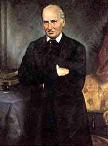
Mariano Ospina Rodríguez was a Colombian politician, journalist and lawyer, founder of the Colombian Conservative Party and later President of Colombia between 1857 and 1861 during the Granadine Confederation.
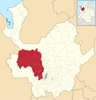
Western Antioquia is a subregion in the Colombian Department of Antioquia. The region is made up by 18 municipalities.

Alexis Enrique García Vega is a Colombian retired football midfielder. He is currently the manager of La Equidad in the Categoría Primera A.

Antioquia State was one of the states of Colombia, which existed from 1856 until 1886. Today the area of the former state makes up most of modern day Antioquia Department, Colombia.

LaMia Flight 2933 was a charter flight of an Avro RJ85, operated by LaMia, that on 28 November 2016 crashed near Medellín, Colombia, killing 71 of the 77 people on board. The aircraft was transporting the first-team squad of Brazilian football club Chapecoense and their entourage from Santa Cruz de la Sierra, Bolivia, to Medellín, where the team was scheduled to play at the 2016 Copa Sudamericana Finals. One of the four crew members, three of the players, and two other passengers survived with injuries.


