Murillo is a town and municipality in the Tolima department of Colombia. The population of the municipality was 4,953 as of the 2005 census, 1,569 who lived within the town of Murillo, the remainder in rural areas of the municipality.
Argelia is a town and municipality in Antioquia Department, Colombia. Part of the subregion of Eastern Antioquia. The population was 8,911 in 2005.

Belmira is a town and municipality in the northern subregion of the Colombian department of Antioquia. It is approximately 62 km from the city of Medellin. It lies at an altitude of 2,550 m above sea level.
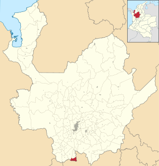
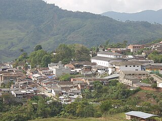
Caramanta is a town and municipality in the Colombian department of Antioquia. It is part of the sub-region of Southwestern Antioquia.
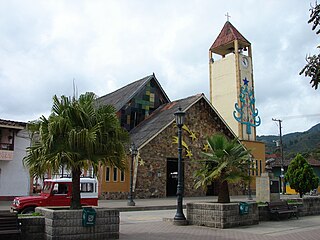
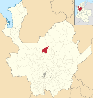
Gómez Plata is a town and municipality in the Colombian department of Antioquia. It is part of the subregion of Northern Antioquia. The population was 8,235 at the 2018 census.

Granada is a town and municipality in the Colombian department of Antioquia. The population was 9,204 at the 2018 census. It is part of the subregion of Eastern Antioquia. For More Info AmigranadaArchived 2007-10-09 at the Wayback Machine

Sonsón is a municipality in the Colombian department of Antioquia. Sonsón is located in Eastern Antioquia. It is one of the seats of the Roman Catholic Diocese of Sonsón–Rionegro. Sonsón celebrates "Las Fiestas Del Maíz"- during the month of August, being the most traditional, historical and representative festival in western Colombia. The population was estimated to be 33,598 in 2020.

Sopetrán is a municipality of Colombia, located in the subregion west of the state of Antioquia. It is bounded to the north by the municipality of Olaya, to the east by the municipality of Belmira, to the south by the municipalities of San Jerónimo and Ebéjico, and to the west by the municipality of Santa Fe de Antioquia. The population was 13,748 at the 2018 census. It is 59 kilometers from the city of Medellin, the state capital of Antioquia. The municipality of Sopetrán has an area of 223 square kilometers.
Briceño is a town and municipality in Antioquia Department, Colombia. Part of the subregion of Northern Antioquia, it lies at an altitude of 1,200 m above sea level.

Chikhli is a midsize town in Navsari district in the state of Gujarat, India.

Toledo is a Colombian municipality and town located in the department of North Santander. It is on the border with Boyacá Department and has natural gas development in the township of Gibraltar. In August 2011 the Gibraltar to Bucaramanga gas pipeline was completed.

Vetas is a town and municipality in the Santander Department in northeastern Colombia.

Villamaría is a town and municipality in the Colombian Department of Caldas. Located in the Colombian coffee growing axis, it was made part of the "Coffee Cultural Landscape" UNESCO World Heritage Site in 2011.

Guamal is a town and municipality in the Meta Department, Colombia.

Lejanías is a town and municipality in the Meta Department, Colombia.

Restrepo is a town and municipality in the Meta Department, Colombia.

Nariño is a town and municipality in the Nariño Department, Colombia.
The climate of Hyderabad is semi-arid, featuring too little rain to feature the tropical savanna climate. The days are hot and dry, usually going up to extreme highs of 40 °C (104 °F), while the nights are cool and breezy. Winds usually bring along clouds of dust, and people prefer staying indoors in the daytime, while the breezes at night are pleasant and clean.

The climate of Agra features a semi-arid climate that borders on a humid subtropical climate. The city features mild winters, hot and dry summers and a monsoon season. The monsoon, though substantial in Agra, is not quite as heavy as the monsoon in other parts of India. The average monsoon rainfall from June to September is 628.6 millimeters. Agra has a reputation of being one of the hottest and the coldest towns in India. In summer the city witnesses a sudden surge in temperature and at times, mercury goes beyond the 46 °C mark in addition to a very high level of humidity. During summer, the daytime temperature hovers around 46-50 °C. Nights are relatively cooler and temperature lowers to 30 °C. Winter minimum temperatures sometimes go as low as 3 or 3.5 °C but usually hover in the range of 6 to 8 °C.

According to the Köppen climate classification, the climate of New York City is humid subtropical (Cfa), with parts of the city transitioning into a humid continental climate. (Dfa). The city experiences moderately cold, somewhat wet and snowy winters; and hot, humid summers with plentiful rainfall all year round. Also, New York's enormous population, human activity, and vast amounts of large buildings and streets, which absorb sunlight during the day, contribute significantly to the urban heat island effect. Were it not for this phenomenon, its climate would probably be within the humid continental temperature range.