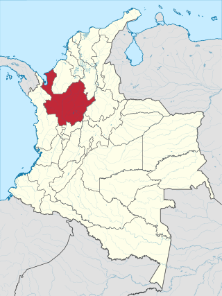
Antioquia is one of the 32 departments of Colombia, located in the central Northwestern part of Colombia with a narrow section that borders the Caribbean Sea. Most of its territory is mountainous with some valleys, much of which is part of the Andes mountain range. Antioquia has been part of many territorial divisions of former countries created within the present-day territory of Colombia. Prior to adoption of the Colombian Constitution of 1886, Antioquia State had its own sovereign government.

Colombia is a unitary republic made up of thirty-two departments and a Capital District. Each department has a governor (gobernador) and an Assembly, elected by popular vote for a four-year period. The governor cannot be re-elected in consecutive periods. Departments are country subdivisions and are granted a certain degree of autonomy.

Coahuila y Tejas, officially the Estado Libre y Soberano de Coahuila y Tejas, was one of the constituent states of the newly established United Mexican States under its 1824 Constitution.

Minas is the capital of the Lavalleja Department in Uruguay. As of the census of 2011, it is the twelfth-most populated city in the country.

Amalfi is a town and municipality of the Colombian Andes, northern part of the Central Mountain Range in the Antioquia Department and part of the subregion of Northeastern Antioquia. The territory of Amalfi is bordered by the municipalities of Anorí and Segovia at its north; Segovia, Remedios and Vegachí at the east; Vegachí, Yalí, Yolombó and Gómez Plata at the south and Anorí and Guadalupe at the west. The town is served by Amalfi Airport.

Santa Fe de Antioquia is a municipality in the Antioquia Department, Colombia. The city is located approximately 58 kilometres (36 mi) north of Medellín, the department capital. The population was 23,216 at the 2018 census.

Ebéjico is a town and municipality in the West of Antioquia Department, Colombia.

Itagüí is a city and municipality of Colombia, located in the south of the Aburrá Valley in the Antioquia Department. It is part of the Metropolitan Area of the Aburrá Valley.

Santa Rosa de Osos is a middle city and municipality of Colombia located in the northern of the department of Antioquia. Bounded on the north with the municipalities of Yarumal and Angostura, on the east with Guadalupe and Carolina del Principe, on the south with the municipalities of Donmatías, San Pedro de los Milagros and Entrerríos, and on the west with Belmira and San José de la Montaña.

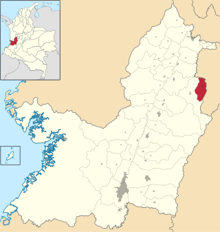
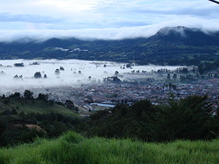
Yarumal is a municipality in the Antioquia Department, Colombia. The municipality has an area of 738.3 km2 (285.1 sq mi). The population was 41,542 at the 2018 census. Its average elevation is 2,265 m (7,431 ft) above sea level.

Puerto Berrío is a municipality and town in the Colombian department of Antioquia. It is part of the Magdalena Medio Antioquia sub-region.
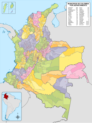
The municipalities of Colombia are decentralized subdivisions of the Republic of Colombia. Municipalities make up most of the departments of Colombia with 1,122 municipalities (municipios). Each one of them is led by a mayor (alcalde) elected by popular vote and represents the maximum executive government official at a municipality level under the mandate of the governor of their department which is a representative of all municipalities in the department; municipalities are grouped to form departments.

The Royal Audiencia of Santiago was an Audiencia Real or royal law court that functioned in Santiago de Chile during the Spanish colonial period. This body heard both civil and criminal cases. It was founded during the 17th century and abolished in 1817.
Caicedonia is a town and municipality located in the Department of Valle del Cauca, Colombia, situated about 172 km from the capital Cali. Founded in 1910 by Daniel Gutierrez, Juan Bautista Angely and a group of settlers from Antioquia, Caldas, and Tolima, it was named after Lisandro Caicedo and became a municipality in 1923. Mostly mountainous, its economy is based on agriculture and commerce, its main exports are corn, coffee, sugarcane and bananas. Given its location on the border with the Quindío Department, only 35 km from that department's capital, Armenia, Caicedonia belongs ethnographically and culturally to the Paisa region.
The History of the Department of Antioquia began with the arrival of the first human settlers into what is now the Antioquia Department in Colombia. These first settlers are presumed to have arrived from mesoamerica in Central America, some 10,500 years BC, although there is some evidence of human vestiges that may date to 22,000 years BC.

Nechí River is a river of northwestern Colombia. It flows into the Cauca River. Nechí River rises in the municipality of Yarumal, and serves as a boundary between the municipalities of Antioquia, Campamento, Angostura, Anorí, Yarumal, Valdivia, Tarazá, Cáceres, Zaragoza, El Bagre, Caucasia and Nechí. Significant gold deposits have been found in the area.
La Ceja del Tambo, known as La Ceja, is a town and municipality in the Antioquia Department of Colombia. It is part of the subregion of Eastern Antioquia. La Ceja borders the Rionegro and Carmen de Viboral municipalities to the north, La Unión to the east, and Montebello and Retiro to the west. It is located approximately 41 kilometers from Medellín, the department capital.
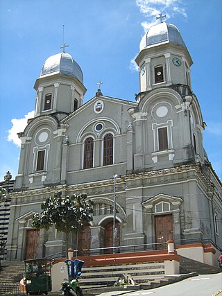
The Basilica of Our Lady of Mercy is a minor basilica in Yarumal, Colombia. It belongs to the Roman Catholic Diocese of Santa Rosa de Osos, and is the seat of the parish of the same name. The basilica is devoted to the Virgin Mary, and the patron saint is the Virgin of Mercy. It is the titular church of Saint Aloysius Gonzaga.

Juan de Dios Aranzazu (1798–1845) was a Colombian politician.


