
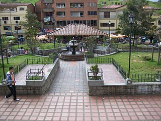
Alejandría is a town and municipality in the Antioquia Department, Colombia. It is part of the sub-region of Eastern Antioquia and is bordered to the north by the municipalities of Concepción, Santo Domingo and San Roque, on the east by the municipality of San Rafael, on the south by the municipalities of San Rafael and Guatapé, and on the west by the municipalities of El Penol and Concepción. Its capital is 90 kilometers from the city of Medellin, the capital of Antioquia department. The municipality has an area of 149 km2.

Santa Fe de Antioquia is a municipality in the Antioquia Department, Colombia. The city is located approximately 58 kilometres (36 mi) north of Medellín, the department capital. The population was 23,216 at the 2018 census.

Arboletes is a town and municipality in the subregion of Urabá in Antioquia Department, Colombia.

Bolívar is a town and municipality in Antioquia Department, Colombia. Part of the sub-region of Southwestern Antioquia, it is known as the birthplace of professional international cyclists Carlos Betancur and Julián Arredondo.

Cañasgordas is a town and municipality in Antioquia Department, Colombia. The population was 13,595 at the 2018 census.
Don Matías is a municipality in Antioquia Department, Colombia. Part of the subregion of Northern Antioquia. Bordered to the north by the municipality of Santa Rosa de Osos, to the east by the municipalities of Santa Rosa de Osos and Santo Domingo, to the south by the municipality of Barbosa, and to the west by the municipality of San Pedro de los Milagros.

Ebéjico is a town and municipality in the West of Antioquia Department, Colombia. The population was 10,338 at the 2018 census.

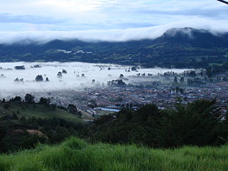
Guatapé is a town and municipality in the Department of Antioquia, Colombia. It is a part of the subregion of Eastern Antioquia and is located 79 kilometres (49 mi) from Medellín, the capital of the department. Guatapé is bordered on the north by Alejandría, San Rafael to the east, and Granada and El Peñol to the south. This town is the gathering place for Las Vegas, referring to the small farms of the area.
La Unión is a municipality in Colombia, located in the Eastern subregion of the department of Antioquia. It is bordered to the north by the municipalities of La Ceja and El Carmen de Viboral, to the east by El Carmen de Viboral, to the south by the municipality of Abejorral, and to the west by the municipality of La Ceja. Its capital is 57 kilometers away from Medellín, the capital of the department of Antioquia. The municipality covers an area of 198 square kilometers.
San Vicente Ferrer is a town and municipality in Antioquia Department, Colombia. The population was 18,051 at the 2018 census. The town of San Vicente is part of the sub-region of Eastern Antioquia.

Sonsón is a municipality in the Colombian department of Antioquia. Sonsón is located in Eastern Antioquia. It is one of the seats of the Roman Catholic Diocese of Sonsón–Rionegro. Sonsón celebrates "Las Fiestas Del Maíz"- during the month of August, being the most traditional, historical and representative festival in western Colombia. The population was estimated to be 33,598 in 2020.

Sopetrán is a municipality of Colombia, located in the subregion west of the state of Antioquia. It is bounded to the north by the municipality of Olaya, to the east by the municipality of Belmira, to the south by the municipalities of San Jerónimo and Ebéjico, and to the west by the municipality of Santa Fe de Antioquia. The population was 13,748 at the 2018 census. It is 59 kilometers from the city of Medellin, the state capital of Antioquia. The municipality of Sopetrán has an area of 223 square kilometers.

Puerto Berrío is a municipality and town in the Colombian department of Antioquia. It is part of the Magdalena Medio Antioquia sub-region.

Puerto Nare is a town and municipality in the Colombian department of Antioquia. It is part of the Magdalena Medio Antioquia sub-region.

Rionegro is a city and municipality in Antioquia Department, Colombia, located in the subregion of Eastern Antioquia. The official name of the city is Ciudad Santiago de Arma de Rionegro. Rio Negro means "Black River" in Spanish, as the city received its name after a river that looks black because of the shadows cast by trees. The river traverses the city and it is the most prominent geographical feature of the municipality. Rionegro is also sometimes called the Cuna de la democracia as it was one of the most important cities during the era of the Colombia's struggle for independence and the 1863 constitution was written in the city.

San Rafael is a town and municipality in Antioquia Department, Colombia. Part of the subregion of Eastern Antioquia.
San Jerónimo is a municipality in Colombia, located in the Western subregion of the Department of Antioquia. Its main town is 35 kilometers from the city of Medellín, the capital of the department of Antioquia. The municipality has an area of 155 square kilometers.

San Luis is a municipality in Colombia, located in the department of Antioquia. It is limited in the north by the municipalities of San Carlos and Puerto Nare, in the east by the municipality of Puerto Triunfo, in the south by the municipality of San Francisco and in the west by the municipalities of Cocorná and Granada.

San Pedro de los Milagros is a town and municipality in the Colombian department of Antioquia. Part of the subregion of Northern Antioquia, its population was 17,119 at the 2018 census.
La Ceja del Tambo, known as La Ceja, is a town and municipality in the Antioquia Department of Colombia. It is part of the subregion of Eastern Antioquia. La Ceja borders the Rionegro and Carmen de Viboral municipalities to the north, La Unión to the east, and Montebello and Retiro to the west. It is located approximately 41 kilometers from Medellín, the department capital.


