Colony is a town in Cullman County, Alabama, United States. At the 2010 census the population was 268, down from 385 in 2000. Colony is a historically African-American town. In its early days it was a haven for African Americans in the Deep South. It incorporated in 1981.

Aubrey is a town in Lee County, Arkansas, United States. The population was 108 at the 2020 census.

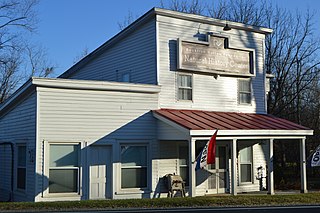
Varnell is a city in Whitfield County, Georgia, United States. It is part of the Dalton, Georgia Metropolitan Statistical Area. The population was 2,179 at the 2020 census.
Port Sheldon Township is a civil township of Ottawa County in the U.S. state of Michigan. As of the 2020 census, the township population was 5,206.

Jenera is a village in Hancock County, Ohio, United States. The population was 257 at the 2020 census. It is surrounded by Van Buren Township and is part of the Cory-Rawson Local School District.
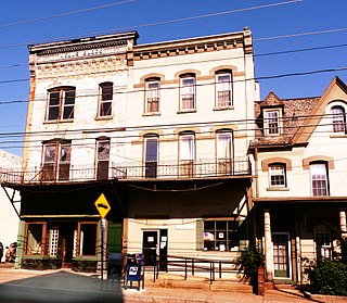
Ashley is a borough in Luzerne County, Pennsylvania, one mile (2 km) from Wilkes Barre. The population was 2,588 at the 2020 census.

Pringle is a borough in Luzerne County, Pennsylvania, United States. As of the 2020 census, the borough population was eight hundred and ninety-one.

Zoar is a census-designated place (CDP) and unincorporated community in Menominee County, Wisconsin, United States. The population was 107 at the 2020 census. Zoar is located along Wisconsin Highway 47, approximately 3 miles (4.8 km) northwest of Neopit. Situated within traditional Menominee territory, it is known in the Menominee language as Saqnawehnaen, a name which refers to a fork in a stream.

Schaghticoke is a village in Rensselaer County, New York, United States. The population was 592 at the 2010 census.
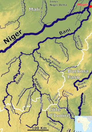
The Bani River is the principal tributary of the Niger River in Mali. The river is formed from the confluence of the Baoulé and Bagoé rivers some 160 km (99 mi) east of Bamako and it merges with the Niger near Mopti. Its length is about 1,100 km (680 mi).
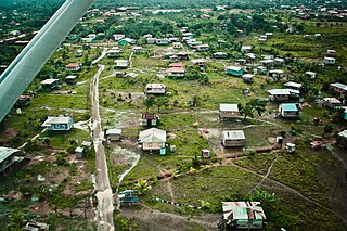
Puerto Cabezas is a municipality and city in Nicaragua. It is the capital of Miskito nation in the North Caribbean Coast Autonomous Region.

Sopetrán is a municipality of Colombia, located in the subregion west of the state of Antioquia. It is bounded to the north by the municipality of Olaya, to the east by the municipality of Belmira, to the south by the municipalities of San Jerónimo and Ebéjico, and to the west by the municipality of Santa Fe de Antioquia. The population was 13,748 at the 2018 census. It is 59 kilometers from the city of Medellin, the state capital of Antioquia. The municipality of Sopetrán has an area of 223 square kilometers.

Urrao is a town and municipality of Colombia, located in the subregion southwest of the department of Antioquia. Limited by the north with the municipalities of Frontino and Abriaquí, in the east with the municipalities of Abriaquí, Caicedo, Anzá, Betulia and Salgar, and in the south and west with Vigía del Fuerte and the department of Chocó. It is the second largest municipality in the department. As of 2015, the population comprised 44,648 people. Professional cyclist Rigoberto Urán was born and raised here.
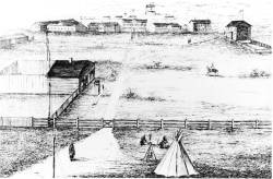
Fort Livingstone was founded as an outpost in North-West Territories, Canada. The outpost briefly served as the capital city for the North-West Territories government for the years of 1874 to 1876 until it moved to Battleford, Saskatchewan, and headquarters for the North-West Mounted Police for the same period, until they moved their headquarters to Fort Macleod, Alberta.
Thirumalayampalayam is a panchayat town in Coimbatore district in the Indian state of Tamil Nadu. It is an important suburb of Coimbatore.
Wintergreen is a census-designated place (CDP) in Augusta and Nelson counties, Virginia, United States, located near Wintergreen Resort. The population as of the 2010 Census was 165.
Kapp Heights is a census-designated place located in Point Township, Northumberland County in the state of Pennsylvania. The community is located very close to the borough of Northumberland along Pennsylvania Route 147, near the confluence of the West Branch Susquehanna River and Susquehanna Rivers. As of the 2010 census the population was 863 residents.
Nahant Bay is an Atlantic Ocean bay, fronted by Swampscott, Lynn, and Nahant, Massachusetts. Egg Rock is located in the Nahant Bay.
Cordelia is an unincorporated community in Hancock County, in the U.S. state of Ohio.
Barnesville is an unincorporated community in Macon County, in the U.S. state of Missouri.