Santa Fe de Antioquia is a municipality in the Antioquia Department, Colombia. The city is located approximately 58 kilometres (36 mi) north of Medellín, the department capital. The population was 23,216 at the 2018 census.
Argelia is a town and municipality in Antioquia Department, Colombia. Part of the subregion of Eastern Antioquia. The population was 8,911 in 2005.

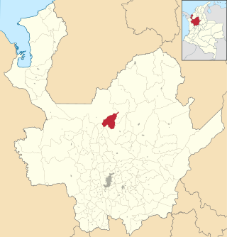
Belmira is a town and municipality in the northern subregion of the Colombian department of Antioquia. It is approximately 62 km from the city of Medellin. It lies at an altitude of 2,550 m above sea level.
Caramanta is a town and municipality in the Colombian department of Antioquia. It is part of the sub-region of Southwestern Antioquia.

Cocorná is a town and municipality in the Colombian department of Antioquia. The population was 14,743 at the 2018 census. It is part of the subregion of Eastern Antioquia.

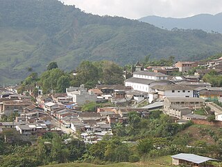
Concepción is a town and municipality in the Colombian department of Antioquia. It is part of the subregion of Eastern Antioquia and located 75km from Medellin.
Gómez Plata is a town and municipality in the Colombian department of Antioquia. It is part of the subregion of Northern Antioquia. The population was 8,235 at the 2018 census.

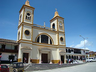
Heliconia is a town and municipality in Antioquia Department, Colombia.
La Unión is a town and municipality in the Colombian department of Antioquia. The population was 20,769 at the 2018 census. It is part of the subregion of Eastern Antioquia.

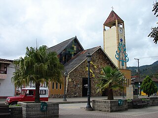
Sonsón is a municipality in the Colombian department of Antioquia. Sonsón is located in Eastern Antioquia. It is one of the seats of the Roman Catholic Diocese of Sonsón–Rionegro. Sonsón celebrates "Las Fiestas Del Maíz"- during the month of August, being the most traditional, historical and representative festival in western Colombia. The population was estimated to be 33,598 in 2020.

San Roque is a town and municipality in the Colombian department of Antioquia. Part of the subregion of Northeastern Antioquia, it is located 1,475 m above sea level. The municipality was founded by Francisco Martinez de Ospina on the 8 February 1880. The town is located between the Nare River and the Nus River. The town was created due to the presence of gold in the areas around the town. The town is located 121 km north of Medellín. The people of this town celebrate most of the traditional festivals that are celebrated in Colombia.

Sopetrán is a municipality of Colombia, located in the subregion west of the state of Antioquia. It is bounded to the north by the municipality of Olaya, to the east by the municipality of Belmira, to the south by the municipalities of San Jerónimo and Ebéjico, and to the west by the municipality of Santa Fe de Antioquia. The population was 13,748 at the 2018 census. It is 59 kilometers from the city of Medellin, the state capital of Antioquia. The municipality of Sopetrán has an area of 223 square kilometers.

Yarumal is a municipality in the Antioquia Department, Colombia. The municipality has an area of 738.3 km2 (285.1 sq mi). The population was 41,542 at the 2018 census. Its average elevation is 2,265 m (7,431 ft) above sea level.
Briceño is a town and municipality in Antioquia Department, Colombia. Part of the subregion of Northern Antioquia, it lies at an altitude of 1,200 m above sea level.

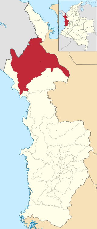
Turbo is a port city in Antioquia Department, Colombia. Part of the Urabá Antioquia sub-region, it is located on the coast of Gulf of Urabá, 340 km north of Medellín. This port city is the capital of the Urabá region of Antioquia. The place where Turbo is today was known as Pisisí, but by 1741 people were already talking about Turbo. By a decree on May 11, 1839, the central government spent one thousand pesos for military service barracks in Turbo. In 1840, the republican president assigned one thousand fanegas of uncultivated lands for the new population. It was established as a municipality in 1847.

Acandí is a town in Colombia at the northern extremity of the department of Chocó in the northwest of Colombia, bordering Panama and the Caribbean Sea. It is 366 km (227 mi) from the department's capital, Quibdó. Its average temperature is 28 degrees Celsius (82 °F). It was founded around the year 1887, and it became a municipality in 1905, previously being part of Turbo. The name "Acandí" is a corruption of the indigenous word "Acanti", which means "River of Stone".
Riosucio is a municipality and town in the Department of Chocó, Colombia. The municipality and town are located in the Atrato River basin, on the Chocoan side of Urabá, a region spanning the departments Chocó and Antioquia.

Guamal is a town and municipality in the Meta Department, Colombia.

Lejanías is a town and municipality in the Meta Department, Colombia.

Restrepo is a town and municipality in the Meta Department, Colombia.