Puerto Boyacá is a Colombian river-port town and municipality by the Magdalena River in the Boyacá Department, where is also considered a Special Trade Zone due to its port status. Its main industries are oil exploration and processing. In the 1980s and early 1990s, Puerto Boyacá was affected intensively by the Colombian Armed Conflict.
Nentón is a town and municipality in the Guatemalan department of Huehuetenango. Its territory extends 717 km2 with a population of 45,679. It became a municipality on December 5, 1876 and was formerly known as San Benito Nentón. The population speaks Spanish and Chuj.

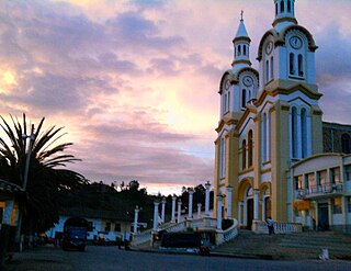
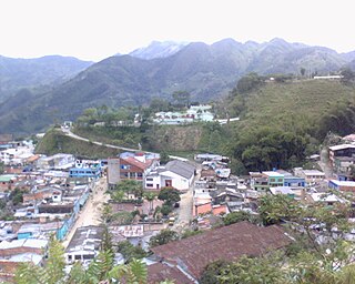
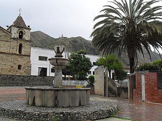
Sutatenza is a town and municipality in the Eastern Boyacá Province of the department of Boyacá, Colombia. It is located 125 kilometres (78 mi) from the Colombian capital Bogotá and 118 kilometres (73 mi) from the department capital Tunja. Sutatenza borders Somondoco, Guateque, Tenza and Garagoa.

Chiquinquirá is a town and municipality in the Colombian Department of Boyacá, part of the subregion of the Western Boyacá Province. Located some 115 km north of Bogotá, Chiquinquirá is situated 2,556 metres (8,386 ft) above sea level and has a yearly average temperature 58 °F (14 °C)

Tame is a town and municipality in the Arauca Department, Colombia. The municipality has a total area of around 5,419 square kilometres or 2,090 square miles.

Manatí is a Colombian municipality located to the south of the Atlántico department, approximately 44 miles from Barranquilla. It was created in 1639 in a place the natives used to call Mahabana. Its current population according to the latest DANE's census is 13.456 people.

Charalá is a town and municipality in the south of the department of Santander in northeastern Colombia. Its antipode is located within the capital of Indonesia, Jakarta.

Tauramena is a town and municipality in the Department of Casanare, Colombia.
Cómbita is a town and municipality in the Colombian Department of Boyacá, part of the sub region of the Central Boyacá Province. Cómbita is situated on the Altiplano Cundiboyacense and borders Arcabuco and the department of Santander in the north, Sotaquirá in the northeast, Tuta and Oicatá in the east, department capital Tunja at 8.5 kilometres (5.3 mi) away and Motavita in the south and Arcabuco and Motavita in the west.
Boavita is a town and municipality in the Colombian Department of Boyacá, part of the subregion of the Northern Boyacá Province. The urban centre of Boavita is situated in the Eastern Ranges of the Colombian Andes at an altitude of 2,114 metres (6,936 ft) and a distance of 184 kilometres (114 mi) from the department capital Tunja. The municipality borders Capitanejo, Santander, and the Nevado River in the north, San Mateo and La Uvita in the east, Tipacoque and Soatá in the west and Susacón in the south.
Quípama is a town and municipality in the Colombian Department of Boyacá, part of the subregion of the Western Boyacá Province.
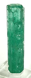
San Pablo de Borbur is a town and municipality in the Colombian Department of Boyacá, part of the subregion of the Western Boyacá Province. The three most important productive sectors are agriculture, livestock and mining, with the emerald being one of the representative elements of the region.
Chiscas is a town and municipality in the Colombian Department of Boyacá, part of the subregion of the Gutiérrez Province.

Chita is a town and municipality in the Colombian Department of Boyacá, part of the Valderrama Province a subregion of Boyaca in Colombia.
Pajarito is a town and municipality in the La Libertad Province, part of the Colombian department of Boyacá. The municipality, situated in the southeast of the department borders Labranzagrande and Aquitania of the department of Boyacá and Yopal, Recetor and Aguazul of the department of Casanare. The urban centre is located at a distance of 147 kilometres (91 mi) from the department capital Tunja at an altitude of 800 metres (2,600 ft) in a tight valley, not allowing much expansion of the urban area. The centre is experiencing periodic landslides.

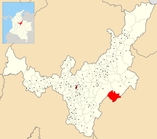
Campohermoso is a town and municipality in the Colombian Department of Boyacá, part of the subregion of the Lengupá Province.

Nuevo Colón is a town and municipality in the Colombian Department of Boyacá, part of the subregion of the Márquez Province. The urban centre is located at an altitude of 2,500 metres (8,200 ft) on the Altiplano Cundiboyacense, at a distance of 34 kilometres (21 mi) from the departmental capital Tunja. Nuevo Colón borders Boyacá, Boyacá, Ventaquemada and Jenesano in the north, Tibaná and Turmequé in the south, Tibaná in the east and Turmequé and Ventaquemada in the west.

Arcabuco is a town and municipality in the Ricaurte Province, part of the Colombian Department of Boyacá. Arcabuco is situated on the Altiplano Cundiboyacense with the urban centre at an altitude of 2,739 metres (8,986 ft). The municipality borders Moniquirá and Gámbita in the north, Villa de Leyva and Chíquiza in the south, Cómbita in the east and Gachantivá and Villa de Leyva in the west. The department capital Tunja is 34 kilometres (21 mi) to the south.
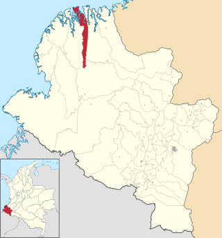
La Tola is a town and municipality in the Nariño Department, Colombia.

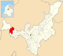
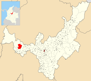
The Western Boyacá Province is a province of the Colombian Department of Boyacá. The province is formed by 15 municipalities. The province hosts the western belt of the rich emerald deposits of Boyacá.