Guavio Formation

Last updated
Guavio Formation
Stratigraphic range: Tithonian-Berriasian
~150–140  Ma
Type Geological formation
Unit of Cáqueza Group
Sub-unitsCaliza de Las Mercedes Mb.
Lutitas de Las Mercedes Mb.
Caliza de Malacara Mb.
Lutitas de Miralindo Mb.
Conglomerado de Miralindo
Underlies Macanal Formation
Overlies Batá Fm., Girón Fm
Thicknessup to 1,000 m (3,300 ft)
Lithology
Primary Conglomerate
Other Limestone, shale
Location
Coordinates 4°59′34.1″N73°28′53.8″W / 4.992806°N 73.481611°W / 4.992806; -73.481611
Region Altiplano Cundiboyacense
Eastern Ranges, Andes
CountryFlag of Colombia.svg  Colombia
Type section
Named for Guavio River
Named byRodríguez & Ulloa
LocationAlto de Miralindo, Guateque
Year defined1976
Coordinates 4°59′34.1″N73°28′53.8″W / 4.992806°N 73.481611°W / 4.992806; -73.481611
Region Cundinamarca, Boyacá
CountryFlag of Colombia.svg  Colombia
Blakey 150Ma - COL.jpg
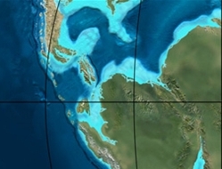
Paleogeography of Northern South America
150 Ma, by Ron Blakey

The Guavio Formation (Spanish : Calizas del Guavio, Kicg) is a geological formation of the Altiplano Cundiboyacense, Eastern Ranges of the Colombian Andes. The formation consists of conglomerates, shales and limestones, dates to the Late Jurassic and Early Cretaceous periods; Tithonian to Berriasian epochs and has a maximum thickness of 1,000 metres (3,300 ft).

Contents

Etymology

The formation was defined and named in 1976 by Rodríguez and Ulloa after the Guavio River, Cundinamarca. [1]

Description

Lithologies

The Guavio Formation has a maximum thickness of 1,000 metres (3,300 ft), and is characterised by a sequence of conglomerates, shales and limestones. [1]

Stratigraphy and depositional environment

The Guavio Formation, the lowermost unit of the Cáqueza Group, overlies the Batá Formation and is overlain by the Macanal Formation. The unit is subdivided into five members, from old to younger; Conglomerado de Miralindo, Lutitas de Miralindo, Caliza de Malacara, Lutitas de Las Mercedes and Caliza de Las Mercedes. The age has been estimated to be Tithonian to Berriasian, spanning the Jurassic-Cretaceous boundary. Stratigraphically, the formation is time equivalent with the Arcabuco Formation. The formation has been deposited in a shallow marine environment in an oxygen-poor basin. [1]

Outcrops

Altiplano Cundiboyacense.png
Green-blue pog.svg
Type locality of the Guavio Formation to the east of the Altiplano Cundiboyacense

The Guavio Formation is apart from its type locality at the Alto de Miralindo and Cuchilla de Manizales, found near Gachalá and Medina. [1]

Regional correlations

Cretaceous stratigraphy of the central Colombian Eastern Ranges
AgePaleomap VMM Guaduas-Vélez W Emerald Belt Villeta anticlinal Chiquinquirá-
Arcabuco
Tunja-
Duitama
Altiplano Cundiboyacense El Cocuy
Maastrichtian Blakey 065Ma - COL.jpg Umir Córdoba Seca eroded Guaduas Colón-Mito Juan
Umir Guadalupe
Campanian Córdoba
Oliní
Santonian La Luna Cimarrona - La Tabla La Luna
Coniacian Oliní Villeta Conejo Chipaque
Güagüaquí Loma Gorda undefined La Frontera
Turonian Blakey 090Ma - COL.jpg Hondita La Frontera Otanche
Cenomanian Simití hiatus La Corona Simijaca Capacho
Pacho Fm. Hiló - Pacho Churuvita Une Aguardiente
Albian Blakey 105Ma - COL.jpg Hiló Chiquinquirá Tibasosa Une
Tablazo Tablazo Capotes - La Palma - Simití Simití Tibú-Mercedes
Aptian Capotes Socotá - El Peñón Paja Fómeque
Paja Paja El Peñón Trincheras Río Negro
La Naveta
Barremian Blakey 120Ma - COL.jpg
Hauterivian Muzo Cáqueza Las Juntas
Rosablanca Ritoque
Valanginian Ritoque Furatena Útica - Murca Rosablanca hiatus Macanal
Rosablanca
Berriasian Blakey 150Ma - COL.jpg Cumbre Cumbre Los Medios Guavio
Tambor Arcabuco Cumbre
Sources

See also

Cscr-candidate.svg Geology of the Eastern Hills
Symbol b class.svg Geology of the Ocetá Páramo
Symbol c class.svg Geology of the Altiplano Cundiboyacense

Related Research Articles

<span class="mw-page-title-main">Simijaca Formation</span>

The Simijaca Formation (Spanish: Formación Simijaca, K2S, Kss) is a geological formation of the Altiplano Cundiboyacense, Eastern Ranges of the Colombian Andes. The predominantly mudstone formation dates to the Late Cretaceous period; Turonian and Cenomanian epochs, and has a maximum thickness of 693 metres (2,274 ft).

<span class="mw-page-title-main">Chipaque Formation</span>

The Chipaque Formation (Spanish: Formación Chipaque, K2cp, Kc) is a geological formation of the Altiplano Cundiboyacense, Eastern Ranges of the Colombian Andes. The formation is also described as Gachetá Formation, named after Gachetá, in the area of the Llanos foothills of the Eastern Ranges. The predominantly organic shale formation dates to the Late Cretaceous period; Cenomanian-Turonian epochs and has a maximum thickness of 1,700 metres (5,600 ft). The formation, rich in TOC, is an important oil and gas generating unit for the giant oilfields Cupiagua and Cusiana of the Eastern Ranges as well as in the Llanos Orientales.

<span class="mw-page-title-main">Guadalupe Group</span>

The Guadalupe Group (Spanish: Grupo Guadalupe, K2G, Ksg) is a geological group of the Altiplano Cundiboyacense, Eastern Ranges of the Colombian Andes. The group, a sequence of shales and sandstones, is subdivided into three formations; Arenisca Dura, Plaeners and Arenisca Labor-Tierna, and dates to the Late Cretaceous period; Campanian-Maastrichtian epochs and at its type section has a thickness of 750 metres (2,460 ft).

<span class="mw-page-title-main">Guaduas Formation</span> Geological formation in the Colombian Andes

The Guaduas Formation (Spanish: Formación Guaduas, K2P1G, K2E1G, KPgg, KTg, TKg, Ktg) is a geological formation of the Middle Magdalena Basin and the Altiplano Cundiboyacense, Eastern Ranges of the Colombian Andes. The predominantly shale with coalbed formation dates to the Late Cretaceous and Paleogene periods; Maastrichtian-Paleocene epochs, and has a maximum thickness of 1,090 metres (3,580 ft). Fossils of Coussapoa camargoi, Ficus andrewsi, Berhamniphyllum sp. and Archaeopaliurus boyacensis have been found in coalbeds in Zipaquirá and Tasco, Boyacá.

<span class="mw-page-title-main">La Frontera Formation</span> Geological formation

The La Frontera Formation (Spanish: Formación La Frontera, K2F, Ksf) is a geological formation, part of the Villeta Group, of the Altiplano Cundiboyacense and neighbouring areas of the Eastern Ranges of the Colombian Andes. The sequence of limestones and lydites dates to the Late Cretaceous period; Turonian epoch and has a maximum thickness of 206 metres (676 ft).

<span class="mw-page-title-main">Conejo Formation</span> Fossiliferous geological formation in the Eastern Ranges of the Colombian Andes

The Conejo Formation (Spanish: Formación Conejo, K2C, Kscn) is a fossiliferous geological formation of the Altiplano Cundiboyacense, Eastern Ranges of the Colombian Andes. The uppermost unit of the Villeta Group, a sequence of shales and sandstones dates to the Late Cretaceous period; Turonian, Coniacian and Santonian epochs, and has a maximum thickness of 1,022 metres (3,353 ft).

<span class="mw-page-title-main">Arcabuco Formation</span> Geological formation in the Colombian Andes

The Arcabuco Formation is a geological formation of the Altiplano Cundiboyacense, Eastern Ranges of the Colombian Andes. The formation consists of thick beds of light-coloured quartzitic sandstones and conglomerates with occasional shales and dates to the Late Jurassic and Early Cretaceous periods; Tithonian to Berriasian epochs. Dinosaur footprints have been found in the Arcabuco Formation near the Iguaque anticlinal outside Chíquiza, Boyacá.

The Murca Formation is a geological formation of the Altiplano Cundiboyacense, Eastern Ranges of the Colombian Andes. The predominantly subarkose sandstone with claystones and siltstones formation dates to the Early Cretaceous period; Valanginian epoch and has a maximum thickness of 924 metres (3,031 ft).

<span class="mw-page-title-main">Hiló Formation</span> Geological formation in the Colombian Andes

The Hiló Formation is a geological formation of the Altiplano Cundiboyacense, Eastern Ranges of the Colombian Andes. The predominantly shale formation dates to the Middle Cretaceous period; Late Albian to Early Cenomanian epochs and has a measured thickness at its type section of 470 metres (1,540 ft). The fossiliferous formation has provided a great abundance of ammonites and other marine species.

<span class="mw-page-title-main">Capotes Formation</span>

The Capotes Formation is a geological formation of the Altiplano Cundiboyacense, Eastern Ranges of the Colombian Andes. The formation consists of calcareous black shales containing gypsum and ammonites and dates to the Early Cretaceous period; Early Albian epoch and has an approximate thickness at its type section of 550 metres (1,800 ft).

<span class="mw-page-title-main">Socotá Formation</span>

The Socotá Formation is a geological formation of the Altiplano Cundiboyacense, Eastern Ranges of the Colombian Andes. The formation consisting of a lower unit of calcareous sandstones and an upper sequence of shales dates to the Early Cretaceous period; Late Aptian epoch and in Quipile has a measured thickness of 255 metres (837 ft) with large regional variations. The formation hosts ammonite fossils.

<span class="mw-page-title-main">El Peñón Formation</span>

The El Peñón Formation is a geological formation of the Altiplano Cundiboyacense, Eastern Ranges of the Colombian Andes. The formation consists of calcareous shales and siltstones and dates to the Early Cretaceous period; Late Aptian epoch and has a measured thickness at its type section of 381 metres (1,250 ft). Ammonite fossils have been found in the formation, deposited in a shallow marine platform environment.

<span class="mw-page-title-main">Trincheras Formation</span>

The Trincheras Formation is a geological formation of the Altiplano Cundiboyacense, Eastern Ranges of the Colombian Andes. The formation consisting of a lower unit of calcareous shales and an upper sequence of shales dates to the Early Cretaceous period; Early Aptian epoch and has a maximum thickness of 1,260 metres (4,130 ft). The formation, deposited in a marine platform environment, part of a transgressive cycle, hosts ammonite, bryozoan, mollusc and echinoid fossils.

The Las Juntas Formation or Las Juntas Sandstone is a geological formation of the Altiplano Cundiboyacense and Tenza Valley, Eastern Ranges of the Colombian Andes. The Las Juntas Formation is found in the departments Cundinamarca, Boyacá and Casanare. The predominantly sandstone formation dates to the Early Cretaceous period; Hauterivian epoch, and has a maximum thickness of 910 metres (2,990 ft).

<span class="mw-page-title-main">Macanal Formation</span>

The Macanal Formation or Macanal Shale is a fossiliferous geological formation of the Altiplano Cundiboyacense and Tenza Valley in the Eastern Ranges of the Colombian Andes. The predominantly organic shale formation dates to the Early Cretaceous period; Berriasian to Valanginian epochs and has a maximum thickness of 2,935 metres (9,629 ft). The Macanal Formation contains numerous levels of fossiliferous abundances. Bivalves, ammonites and fossil flora have been found in the formation.

<span class="mw-page-title-main">Fómeque Formation</span> Geological formation in the Colombian Andes

The Fómeque Formation is a geological formation of the Altiplano Cundiboyacense, Eastern Ranges of the Colombian Andes. The predominantly organic shale formation dates to the Early Cretaceous period; Barremian to Late Aptian epochs and has a maximum thickness of 1,200 metres (3,900 ft).

<span class="mw-page-title-main">Une Formation</span> Geological Formation

The Une Formation is a geological formation of the Altiplano Cundiboyacense, Eastern Ranges of the Colombian Andes. The predominantly sandstone formation dates to the Middle Cretaceous period; Albian to Cenomanian epochs and has a maximum thickness of 1,100 metres (3,600 ft).

<span class="mw-page-title-main">Pacho Formation</span>

The Pacho Formation is a geological formation of the Altiplano Cundiboyacense, Eastern Ranges of the Colombian Andes. The formation consisting of alternating siltstones and shales with siderite concretions dates to the Middle Cretaceous period; Late Albian to Cenomanian epochs and has an approximate thickness of 1,050 metres (3,440 ft).

<span class="mw-page-title-main">Villeta Group</span> Geological group in central Colombia

The Villeta Group is a geological group of the Eastern Ranges of the Colombian Andes, to the west of the Altiplano Cundiboyacense. The group, a sequence of shales, limestones and sandstones, is subdivided into various formations; Conejo, La Frontera, Simijaca, Hiló, Pacho, Chiquinquirá, Capotes, Socotá, El Peñón, and Trincheras, and dates to the Cretaceous period; Aptian-Coniacian epochs. The group stretches out across four departments, from Huila in the south, through Cundinamarca and Boyacá to southern Santander in the north. The upper part of the Villeta Group is time-equivalent with the La Luna Formation of the Middle Magdalena Valley (VMM) and Sierra Nevada del Cocuy, the Oliní and Güagüaquí Groups of the Guaduas-Vélez synclinal and the Chipaque Formation of the Altiplano Cundiboyacense. The lower part has been correlated with the Simití, Tablazo and Paja Formations of the VMM, the upper Tibasosa, Une and Fómeque Formations of the Altiplano Cundiboyacense and the Capacho, Aguardiente, Tibú-Mercedes and upper Río Negro Formations of the Sierra Nevada del Cocuy.

<span class="mw-page-title-main">Oliní Group</span> Fossiliferous geological group

The Oliní Group (Spanish: Grupo Oliní, K3k5o, K2ol, Kso) is a fossiliferous geological group of the VMM, VSM and the eastern flanks of the Central and western flanks of the Eastern Ranges of the Colombian Andes. The regional group stretches from north to south across approximately 700 kilometres (430 mi) and dates to the Late Cretaceous period; Coniacian, Santonian and Campanian epochs, and has a maximum thickness of 287 metres (942 ft). Fossils of Eonatator coellensis have been found in the unit, near Coello, Tolima.

References

  1. 1 2 3 4 Acosta & Ulloa, 2002, p.51

Bibliography

Maps

  • Acosta, Jorge E, and Carlos E. Ulloa. 1998. Plancha 246 - Geología de Fusagasugá - 1:100,000, 1. INGEOMINAS.
  • Ulloa, Carlos E; Erasmo Rodríguez, and Jorge E. Acosta. 1998. Plancha 227 - Geología de La Mesa - 1:100,000, 1. INGEOMINAS.
  • Ulloa, Carlos E; Erasmo Rodríguez, and Ricardo Escovar. 1998. Plancha 192 - Geología de Laguna de Tota - 1:100,000, 1. INGEOMINAS.
  • Renzoni, Giancarlo; Humberto Rosas, and Fernando Etayo Serna. 1998. Plancha 191 - Geología de Tunja - 1:100,000, 1. INGEOMINAS.
  • Fuquen M., Jaime A, and José F. Osorno M. 2009. Plancha 190 - Geología de Chiquinquirá - 1:100,000, 1. INGEOMINAS.
  • Ulloa, Carlos E; Álvaro Guerra, and Ricardo Escovar. 1998. Plancha 172 - Geología de Paz de Río - 1:100,000, 1. INGEOMINAS.
  • Velandia, Francisco, and Héctor Cepeda. 2005. Planchas 171 & 191 - Geología sector del sur del municipio de Paipa (Boyacá) - 1:25,000. INGEOMINAS.